- Dhubri
-
This article is about the municipality in India. For its namesake district, see Dhubri district.
Dhubri — city — Coordinates 26°01′N 90°00′E / 26.02°N 90°ECoordinates: 26°01′N 90°00′E / 26.02°N 90°E Country India State Assam District(s) Dhubri Population 63,965 (2001[update]) Time zone IST (UTC+05:30) Website dhubri.nic.in Dhubri (Assamese: ধুবুৰী) is the headquarters of Dhubri district (Assam) India. It is a small old town on the bank of the Brahmaputra and Gadadhar Rivers. In 1883, the town was first constituted as a Municipal Board and is situated about 280 kilometres (174 mi) west from Guwahati, the state capital.
Dhubri was an important commercial centre and had a busy river port particularly for jute. Partition of the country in 1947 caused Dhubri to become a route for illegal immigrants[1] and militants to cross the international border.
Dhubri is called the "Land of Rivers" as it is covered three sides by rivers. [2]
Contents
History
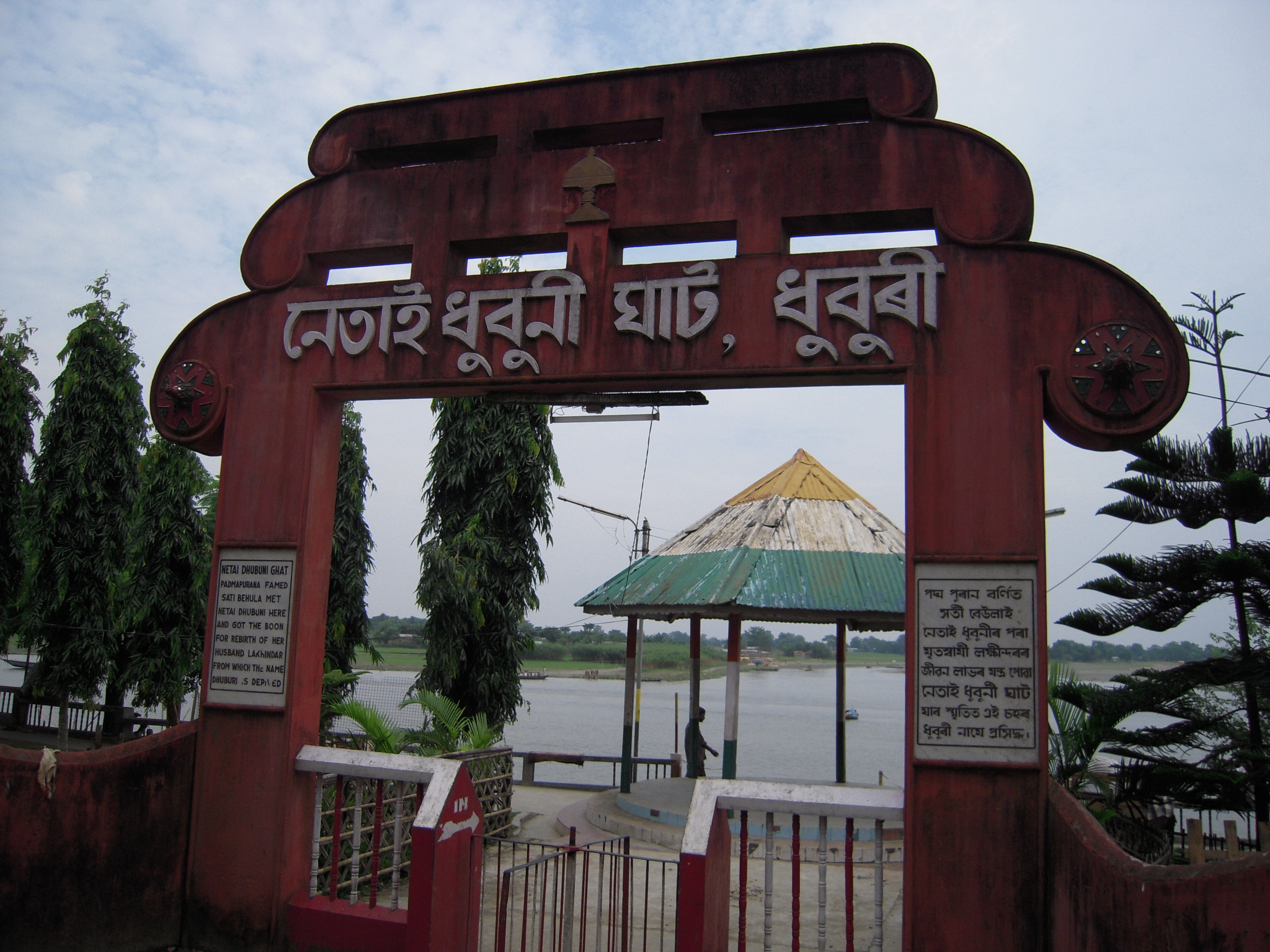
 Historic Netai Dhubuni Ghat at Dhubri
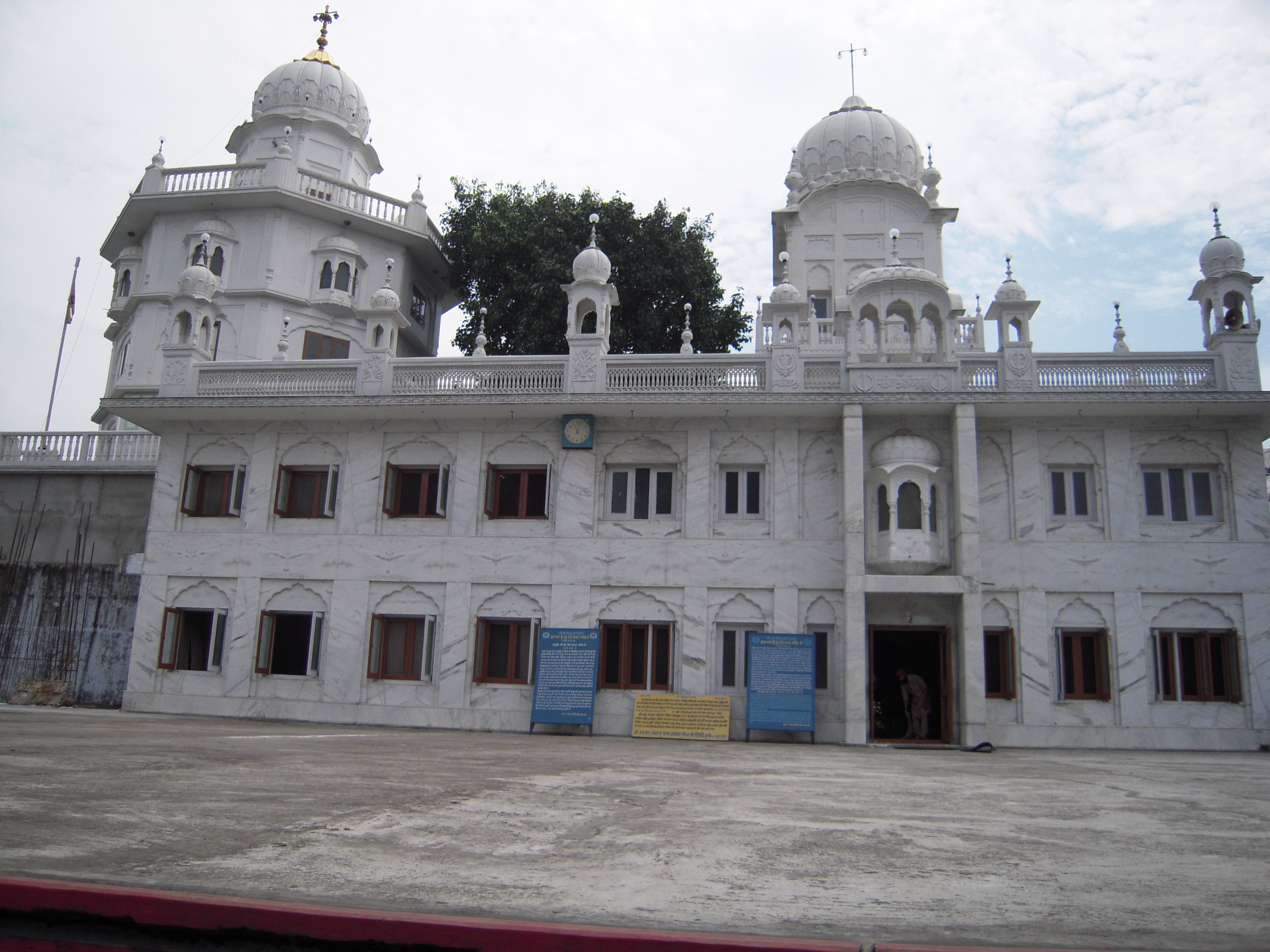
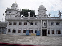 Gurdwara Sri Guru Tegh Bahadur Sahib at Dhubri
The word Dhuburi: ধুবুৰী comes from a legendary lady named Netai-Dhubuni. The story is connected with Behula-Lakhindar. The word Dhubuni is considered a corruption of 'Dhuburi'. According to Bodo-Kacharis, the word is of Bodo origin and derived form Dubra, a kind of grass. The story of lady Netai-Dhubuni is widely accepted for the naming history of Dhubri and that is where the Gurdwara Sri Tegh Bahadur Sahib stands.
This place is famous for the Sikh Gurdwara namely Gurdwara Damdama Sahib or Thara Sahib which was constructed in memory of visit of First Sikh Guru Nanak Dev (Punjabi: ਗੁਰੂ ਨਾਨਕ, Hindi: गुरु नानक, Urdu: گرونانک Guru Nānak) and later it was followed by visit of Ninth guru, Guru Tegh Bahadur (Punjabi: ਗੁਰੂ ਤੇਗ਼ ਬਹਾਦੁਰ, Hindi: गुरू तेग़ बहादुर) and the Gurdwara is named as Gurdwara Sri Guru Tegh Bahadur Sahib. Hence, it has great importance for Sikh community.
Until 1874, Dhubri was mostly a part of Bengal kings. In 1874, the British Government created a new province named Assam Valley Province and incorporated Goalpara district area comprising three civil subdivisions Dhubri, Goalpara and Kokrajhar with the new Assam Province. In 1879, the district headquarters was shifted from Goalpara to Dhubri town. The district of Dhubri is again subdivided in three districts namely Dhubri, Goalpara and Kokrajhar. The town of Dhubri falls under the jurisdiction of the district of Dhubri whose head quarter is at town Dhubri.
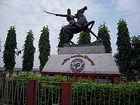 Chilarai Statue at Dhubri
The present Dhubri District is one of the three Civil Sub-divisions of erst-whileGoalpara district, established in 1876 during British regime. In 1879 the District head quarter was shifted from Goalpara to Dhubri.
In the year 1983 Goalpara district was divided into four separate districts and Dhubri is one of those. Covering an area of 2,838 km2. including forests, riverines,hills etc. the district has become the most densely populated district in India with a density of 584 persons per km2.(As per 2001 census).
Dhubri Dist. also withnessed the glorious visit of many of the historical personalities like - Guru Nanaka, Srimanta Sankardeva, Guru Teg Bahadur, Swami Vivekananda, Mahatma Gandhi, Netaji Subhas Chandra Bose, Gopinath Bordoloi and others.
The Dhubri Town was first constituted as a Municipality in 1883. The Dhubri Town is 290 km far from the State Capital at Dispur. For details log on the district website at www.dhubri.gov.in
http://www.scribd.com/doc/59620997/About-Gauripur-and-Dhubri-District
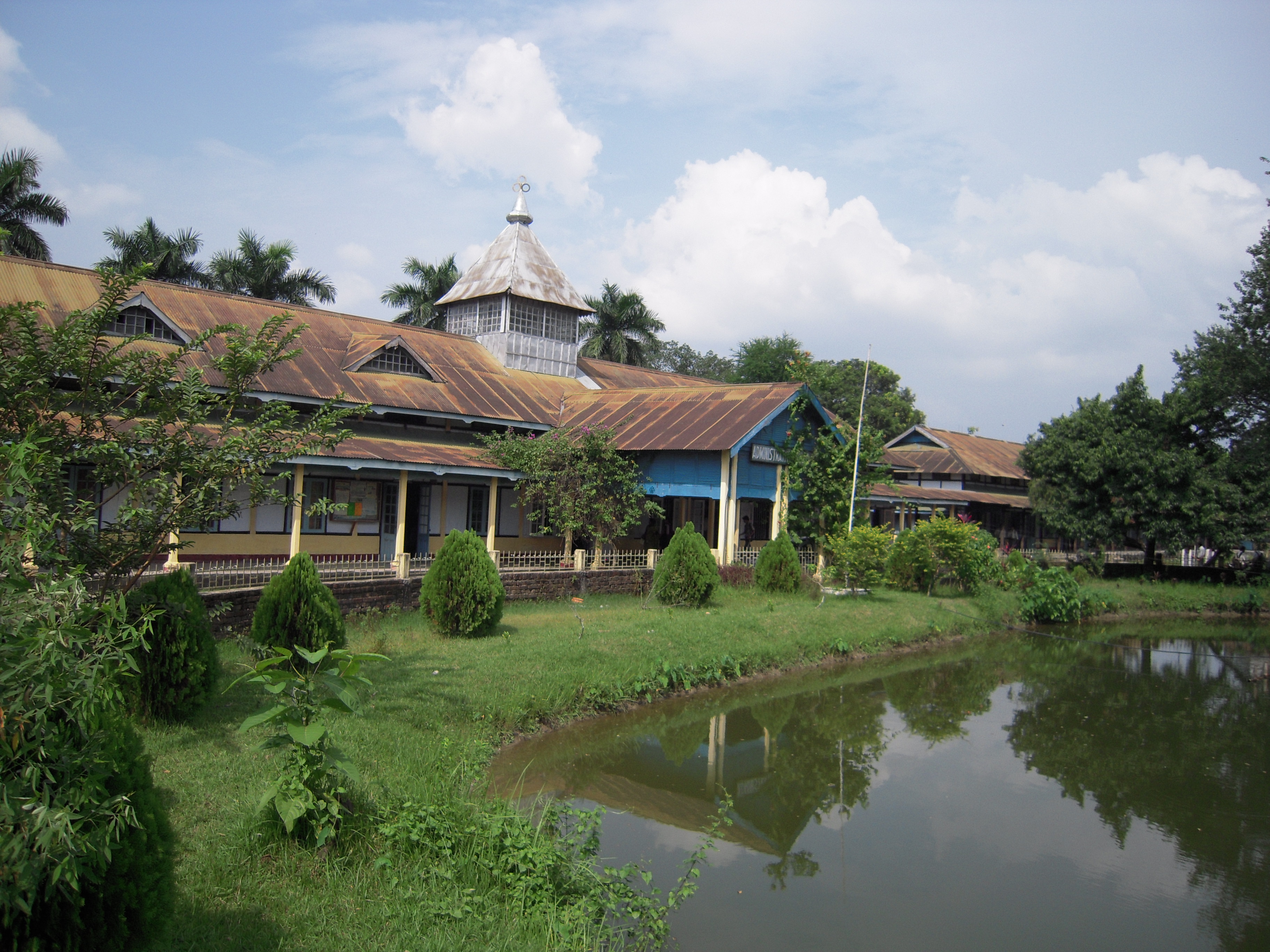
Educational institutes
 Bhola Nath College at Dhubri
- Bholanath College or B. N. College (Established in 1946) is the oldest and premier college in western Assam.
- Dhubri Law College;
- Dhubri Girls' College;
- Dhubri B. T. College.
The premier school of Dhubri are:
- Government Boys' School which has provided quality education for decades.
- Happy Convent School
- S.P. English medium School
- Bidyapara Boys School
- Bidyapara girls School
- Municipal School
- Jawahar Hindi High School
Geography
The town is located between 89.5 degree east longitude and 26.1 degree north latitude. The town is about 34 m above the sea level.
Dhubri is covered by rivers by three sides, predominated by river Mighty Brahmaputra, which is a sorrow as well as joy for the dwellers.
Culture
Around 50,000 Sikh devotees from all over the country and abroad assemble in this historic shrine every year in the month of December to mark the martyrdom of Guru Tegh Bahadur, which starts on 3 December with great solemnity and ceremony. Sikhs call the week long reverence of Sahidee-Guru-Parav which is marked with a massive procession. Guru Tegh Bahadur thus earned the affectionate title of "Hind-di-Chadar" or the Shield of India.
Tourism
Dhubri District is bestowed with attractive scenic beauties. Both the banks of river Brahmaputra with its lush green fields, blue hills and hillock is a feast to the eyes of the onlookers. The Gurdwara Tegh Bahadur Shaibji, the Rangamati Mosque, Mahamaya Dham, Chakrasila wildlife sanctuary and the royal palaces attract the people for their unique structures, religious sanctity and mythological importance.
Gurdwara Sri Guru Tegbahadur Sahibji In the heart of the Dhubri Town and on the bank of the river mighty Brahmaputra, this famous Gurdwara is situated. Sikh Guru Nanak visited this place in 1505 A.D. and met Sri Sankardeva during Guru Nanak Devji's way from Dhaka to Assam.
Thereafter the Ninth Sikh Guru Teg Bahadur came to this place and established the Gurdwara during 17th century accompany of Raja Ram Singh. Sikh devotees from all over India and abroad assembled in this Gurdwara every year in the month of December to mark the Martydom of Sri Guru Teg Bahadur with due solemnity and ceremony. Sikh devotees called reverence of Sahidee-Guru-Parav
Panchpeer Dargaha It is Mazar Sharif of five Sufi Saints who accompanied Raja Ram Singh during his time of Mughal fight with the Ahom Regime of Assam.
Mahamaya Dham Mahamaya Dham of Bogribari, about 30–35 km east from Dhubri town is next to Kamakhya (Guwahati) and Madan-Mohan (Cooch Behar) in its attraction to the pilgrims and tourists. Originally the famous mother Goddess Mahamaya of Parvatjowar was worshipped by the local people like Kacharies, Koches and Naths. It was the presiding deity of the Jaminder of Parvatjowar. Nowadays the mother Mahamaya is worshipped by all Hindus.
Rangamati Mosque Rangamati Mosque or Panbari Mosque was built during 17th century by Hussain Shah, the Governor of Bengal belongs to pre-Mughal period which can be recognised from its typical architectural design. It is about 25 km from township of Dhubri. Rangamati area was once a very prosperous during the reign of the Koch rulers as a frontier post.
During Mughal regime Rangamati was a great fort of the invading Mughal Army. This unique Mosque was used as a prayer place by the Mohmmedan Soldiers. There is also a Idgah and a deep well which were also constructed during the same period.
Other Significant features Two world famous Wetlands - Dheer Beel and Diplai Beel adjoin Chakrasila wildlife Sanctuary. These two Beels are home to a large number of fishes, turtles, prawn and birds both indigenous and migratory.
Chakrasila Wildlife Sanctuary In the year 1994, Chakrasila Hill Reserve Forest was declared as Chakrasila Hill Wildlife Sanctuary by the Govt.of India covering an area of 4558.7 hectares of land. The distribution of varieties of plant species in Chakrasila provides diverse niches for many Wild Life. The Significant Golden Langur exists in Chakrasila Wildlife Sanctuary in addition to other mammals plike Leopard, Leopard cat, Porcupine, Pangoline, Flying Squirrel and Civet cat. Adjutants Stork, Indian Owl, Myna, Parrakit, Dove, Hornbil, Jungle Fowl, Kingfisher, Harren, Darter, Snipe and Teal are the birds commonly found. Python, Monitor, Crait, Cobra, Turtle, Tead and frog are some reptiles and amphibia that are also found.
It is about 70 km away from Dhubri Town. This sanctuary provides facilities / activities such as bird watching, forest trekking, wildlife and nature photography. Local guides are available on payment. There is a site for erecting tents and free accommodation for a group of 15 individuals with hygienic drinking water in the camp Tapoban provided by the local NGOs.
Florican Garden A newly setup garden cum natural park located at Bilasipara about 50 km from Dhubri Town, it is a very attractive tourist place.
Other important places There are many other important places in this District like Matiabag Palace at Gauripur, Netai Dhubuni Ghat at Dhubri Town, Chandardinga Hillock, Dudhnath Mondir at Salkocha, Ramraikuti at Satrasal, Airport of IInd World War and Soreswar beel at Rupshi.
Climate
Climate data for Dhubri Month Jan Feb Mar Apr May Jun Jul Aug Sep Oct Nov Dec Year Record high °C (°F) 27
(81)32
(90)38
(100)39
(102)39
(102)36
(97)35
(95)34
(93)25
(77)33
(91)31
(88)27
(81)39
(102)Average high °C (°F) 23
(73)26
(79)30
(86)31
(88)30
(86)30
(86)30
(86)30
(86)29
(84)29
(84)27
(81)23
(73)28.2
(82.7)Average low °C (°F) 12
(54)13
(55)17
(63)21
(70)23
(73)24
(75)26
(79)26
(79)25
(77)23
(73)18
(64)13
(55)20.1
(68.1)Record low °C (°F) 6
(43)3
(37)10
(50)12
(54)17
(63)21
(70)23
(73)22
(72)21
(70)17
(63)12
(54)8
(46)3
(37)Precipitation mm (inches) 8
(0.31)18
(0.71)46
(1.81)130
(5.12)373
(14.69)605
(23.82)434
(17.09)343
(13.5)368
(14.49)117
(4.61)8
(0.31)3
(0.12)2,453
(96.57)Source: wunderground.com [3] Flora and Fauna
On 14 July 1994, a unique virgin forest patch of Dhubri District of Assam was declared as Wildlife Sanctuary by the gazette notification of the Assam Government. This Sanctuary has been named as "Chakrashila Wildlife Sanctuary". This is the youngest sanctuary of the North East India having an area of 11,260.00 acres (45.5676 km2). Chakrasila is unique because of the presence of Golden Langur (Presbytis geei) which is found nowhere else except along the Assam and Bhutan border. Besides, the virgin forest of Chakrasila Wildlife Sanctuary is endowed with rare specimens of tress, shrubs, medicinal plants, mammals, reptiles and exquisite birds and insects.
Geographical location of the Chakrasila Wildlife Sanctuary is in the latitude 26° 15' to 26° 26' N and logitude 90° 15' to 90 ° 20' E. It is in the District of Dhubri, the western most region of Assam. It is 68 km from the District headquarter Dhubri and 219 km from the Borjhar Airport of Guwahati City.
There are several small springs for quenching the thirst of the wild animals of this Hilly forest. But the two major perennial springs in the Sanctuary are howhowi Jhora and Bamuni Jhora, which flow over the rocks, sparkling and spattering throughout the year, adding to the scenic beauty of the Sanctuary.
Climatic conditions of Chakrasila Wildlife Sanctuary is like that of temperate zone with dry winter and hot summer followed by heavy rains. Annual rainfall is between 200 to 400 cm. Soil is azonal, forestlike and hilly. temperature throughout the year generally varies between 8 °C to 30 °C.
The diverse eco-systems of Chakrasila present a model habitat diversity and support various mammlian spicies like Tiger, leopard, Golden Langur, Leopard Cat, Gaur, Mongoose, Porcupine, Pangoline, Flying Squirrel, Civet Cat etc. Along with all these prolific gifts of the nature Chakrasila has a wide variety of avifauna.
It is to be noted that the two internationally recognized wetlands namely Dhir and Deeplai has not been yet taken inside the declared boundary of the Sanctuary. But they are very a part of the Chakrasila eco-system. It is expected that in due course they will be included within the Sanctuary. Courtesy : Nature's Beckon ( An Environmental Activist of North-East )
Demographics
As of 2001[update] India census,[4] Dhubri had a population of 63,965. Males constitute 51% of the population and females 49%. Dhubri has an average literacy rate of 74%, higher than the national average of 59.5%: male literacy is 79% and, female literacy is 68%. In Dhubri, 11% of the population is under 6 years of age. With close to 75% of its population Muslims, it is one of the minority concentrated districts of India.
Politics
Dhubri is part of Dhubri (Lok Sabha constituency).[5]
See also
- Dhubri (Lok Sabha constituency)
- Railway stations in India
References
- ^ Invisible immigrant, Talukdar, S; FRONTLINE Volume 24 (11) Jun. 02, 2007
- ^ Priceless heritage gets funds to survive, The Telegraph, Calcutta, Oct. 13, 2007
- ^ "Historical Weather for Delhi, India". Weather Underground. http://www.wunderground.com/NORMS/DisplayIntlNORMS.asp?CityCode=42182&Units=both. Retrieved November 27, 2008.
- ^ "Census of India 2001: Data from the 2001 Census, including cities, villages and towns (Provisional)". Census Commission of India. Archived from the original on 2004-06-16. http://web.archive.org/web/20040616075334/http://www.censusindia.net/results/town.php?stad=A&state5=999. Retrieved 2008-11-01.
- ^ "List of Parliamentary & Assembly Constituencies". Assam. Election Commission of India. http://archive.eci.gov.in/se2001/background/S03/AS_ACPC.pdf. Retrieved 2008-10-05.
http://www.scribd.com/doc/59620997/About-Gauripur-and-Dhubri-District
External links
Categories:- Cities and towns in Dhubri district
- Dhubri


Wikimedia Foundation. 2010.