- Dhemaji district
-
This article is about the district. For its eponymous headquarters, see Dhemaji.
Dhemaji district
ধেমাজি জিলা— District — The Brahmaputra River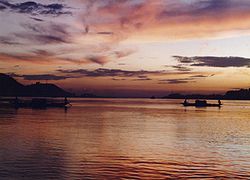 Dhemaji district's location in Assam
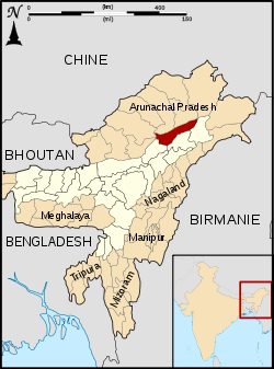
State Assam Country India Seat Dhemaji Area – Total 3,237 km2 (1,249.8 sq mi) Population (2011) – Total 688,077 – Density 212.6/km2 (550.5/sq mi) Time zone IST (UTC+05:30) ISO 3166 code IN-AS-DM Website http://dhemaji.gov.in/ Dhemaji district (Assamese: ধেমাজি জিলা) is an administrative district in the state of Assam in India. The district headquarters are located at Dhemaji. The district occupies an area of 3237 km² and has a population of 571,944 (as of 2001). Main Religions are Hindus 548,780, Muslims 10,533 (1.84%), Christians 6,390.
Contents
Etymology
The town's name "Dhemaji' is believed to be derived from a combination two Assamese words "dhal" meaning flood and "dhemali" meaning "play".
History
The earliest capital of the Tai Ahoms was established in Habung, about 32 kilometres from the headquarters. Ruins of the erstwhile capital are still there but not well preserved. A number of monuments Ghuguha Dol, Ma Manipuri Than, Padumani Than built by the Ahom kings are worth visiting.
Dhemaji became a fully-fledged district on 14 October 1989 when it was split from Lakhimpur district.[1]
Geography
Dhemaji district occupies an area of 3,217 square kilometres (1,242 sq mi),[2] comparatively equivalent to Solomon Islands' Makira Island.[3] It is one of the remotest district of India, at the easetern-most part of Assam. Situated in the foothills of the lower Himalyas it is relatively a small town.
Being in a confluence of rivers with the mighty Brahmaputra river flanking the district and its numerous tributaries running through the district, the region is perennially affected by floods.
The heart of Dhemaji district is Dhemaji Mouza (an area demarcated by the British regime for the purpose of tax collection, equivalent to a taluk or pargana in the pan-Indian context). Secondly, Silapathar & Sissi Borgaon are the main business place of Dhemaji.The Bogibil project is running naerest to these places.
Economy
In 2006 the Indian government named Dhemaji one of the country's 250 most backward districts (out of a total of 640).[4] It is one of the eleven districts in Assam currently receiving funds from the Backward Regions Grant Fund Programme (BRGF).[4]
Divisions
There are two Assam Legislative Assembly constituencies in this district: Dhemaji and Jonai.[5] Both are designated for scheduled tribes.[5] They make up a part of the Lakhimpur Lok Sabha constituency.[6]
Demographics
According to the 2011 census Dhemaji district has a population of 688,077,[7] roughly equal to the nation of Equatorial Guinea[8] or the US state of North Dakota.[9] This gives it a ranking of 504th in India (out of a total of 640).[7] The district has a population density of 213 inhabitants per square kilometre (550 /sq mi) .[7] Its population growth rate over the decade 2001-2011 was 20.3 %.[7] Dhemaji has a sex ratio of 949 females for every 1000 males,[7] and a literacy rate of 69.07 %.[7]
The district is inhabited by Assamese speaking people—Chutia,Ahoms,Sonowal Kacharis, Koches, Kalitas, Kaibartas and other tribes like Mishings and Deoris. Also there are the migrant Hindu and Muslim Bengalis.
Flora and fauna
In 1996 Dhemaji district became home to the Bardoibum-Beelmukh Wildlife Sanctuary, which has an area of 11 km2 (4.2 sq mi).[10] It shares the park with Lakhimpur district.
References
- ^ Law, Gwillim (2011-09-25). "Districts of India". Statoids. http://www.statoids.com/yin.html. Retrieved 2011-10-11.
- ^ Srivastava, Dayawanti et al. (ed.) (2010). "States and Union Territories: Assam: Government". India 2010: A Reference Annual (54th ed.). New Delhi, India: Additional Director General, Publications Division, Ministry of Information and Broadcasting (India), Government of India. pp. 1116. ISBN 978-81-230-1617-7.
- ^ "Island Directory Tables: Islands by Land Area". United Nations Environment Program. 1998-02-18. http://islands.unep.ch/Tiarea.htm. Retrieved 2011-10-11. "Makira 3,190"
- ^ a b Ministry of Panchayati Raj (September 8, 2009). "A Note on the Backward Regions Grant Fund Programme". National Institute of Rural Development. http://www.nird.org.in/brgf/doc/brgf_BackgroundNote.pdf. Retrieved September 27, 2011.
- ^ a b "List of Assembly Constituencies showing their Revenue & Election District wise break - up". Chief Electoral Officer, Assam website. http://ceoassam.nic.in/Gen_Informations/2.1%20-%20DEOs%20wise%20ACs%20breakup.pdf. Retrieved 26 September 2011.
- ^ "List of Assembly Constituencies showing their Parliamentary Constituencies wise break - up". Chief Electoral Officer, Assam website. http://ceoassam.nic.in/Gen_Informations/2.2%20-%20PC-wise%20LAC%20breakup.pdf. Retrieved 26 September 2011.
- ^ a b c d e f "District Census 2011". Census2011.co.in. 2011. http://www.census2011.co.in/district.php. Retrieved 2011-09-30.
- ^ US Directorate of Intelligence. "Country Comparison:Population". https://www.cia.gov/library/publications/the-world-factbook/rankorder/2119rank.html. Retrieved 2011-10-01. "Equatorial Guinea 668,225 July 2011 est."
- ^ "2010 Resident Population Data". U. S. Census Bureau. http://2010.census.gov/2010census/data/apportionment-pop-text.php. Retrieved 2011-09-30. " North Dakota 672,591"
- ^ Indian Ministry of Forests and Environment. "Protected areas: Assam". http://oldwww.wii.gov.in/envis/envis_pa_network/index.htm. Retrieved September 25, 2011.
External links

Lower Subansiri district, Arunachal Pradesh West Siang district, Arunachal Pradesh East Siang district, Arunachal Pradesh 
Tinsukia district  Dhemaji district

Lakhimpur district Dibrugarh district Categories:


Wikimedia Foundation. 2010.