- Dillingham Airfield
-
For the airport in Dillingham, Alaska, see Dillingham Airport.
Dillingham Airfield IATA: HDH – ICAO: PHDH – FAA LID: HDH Location of airport in Hawaii
 HDH
HDHSummary Airport type Public / Military Owner U.S. Army Operator Hawaii Department of Transportation Location Mokuleia, Hawaii Elevation AMSL 14 ft / 4 m Coordinates 21°34′46″N 158°11′50″W / 21.57944°N 158.19722°WCoordinates: 21°34′46″N 158°11′50″W / 21.57944°N 158.19722°W Website Runways Direction Length Surface ft m 8/26 9,007 2,745 Asphalt Statistics (2006) Aircraft operations 68,553 Based aircraft 57 Source: Federal Aviation Administration[1] Dillingham Airfield (IATA: HDH, ICAO: PHDH, FAA LID: HDH) is a public and military use airport located two nautical miles (3.7 km) west of the central business district of Mokulēʻia, in Honolulu County[1] on the North Shore of Oʻahu in the U.S. state of Hawaii. It is operated by the Hawaii Department of Transportation under a 25-year lease from the United States Army. The airport is primarily used for gliding and sky diving operations. Military operations consist largely of night operations for night vision device training.
Contents
History
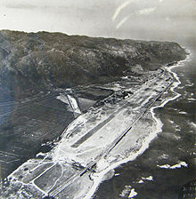 Dillingham Airfield soon after construction during World War II
A communications station called Camp Kawaihapai was established here in 1922 on 67 acres (27 ha) along the Oahu Railway and Land Company line. In the 1920s and 1930s, the railroad transported mobile coast artillery to the site. By 1941, the Army leased additional land and established Mokulēʻia Airstrip. Curtiss P-40 fighters were deployed at North Shore airstrips at Kahuku, Haleʻiwa and Mokulēʻia when the attack on Pearl Harbor took place. Aircraft taking off from nearby Haleʻiwa destroyed several attacking aircraft.[2]
The runway was paved, extended to 9,000 feet (2,700 m) long, and a crosswind runway added from 1942-1945. By the end of World War II, Mokulēʻia Airfield could handle B-29 Superfortress bombers. In 1946, the Army acquired an additional 583 acres (236 ha). In 1948, the airfield was inactivated and renamed Dillingham Air Force Base in memory of Captain Henry Gaylord Dillingham, a B-29 pilot who was killed in action over Kawasaki, Japan on July 25, 1945. Captain Dillingham was the son of Walter F. Dillingham and grandson of Benjamin Dillingham who founded the railroad which evolved into Hawaiian Dredging Company and the Dillingham Corporation.[2]
Nike missiles were installed in the 1950s, but were obsolete by 1970.
In 1962, the State of Hawaii leased Dillingham for general aviation use. In the 1970s the base was transferred from the Air Force back to the Army. The state signed new leases with the Army in 1974 and 1983. In the 1980s, hangars, a control tower, and a fire station were built.[2]
Facilities and aircraft
Dillingham Airfield covers an area of 134 acres (54 ha) at an elevation of 14 feet (4 m) above mean sea level. It has one runway designated 8/26 with an asphalt surface measuring 9,007 by 75 feet (2,745 x 23 m).[1]
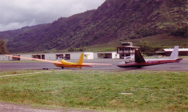
As a general aviation joint-use facility, the airfield has one runway, a UNICOM tower, powered aircraft and glider hangars, and a tie down area for recreation aircraft. Jet-A and Avgas are available in a self-serve facility utilizing credit cards for payment. There were plans to extend the taxiway to the end of the 26 runway, but funding was delayed. Air traffic, unless approved prior by the US Army, is limited to daytime operations by general aviation and sport parachuting operations. Although the largest users on the airfield are the sport parachuting operations, the State of Hawaii refuses safety improvements.
For the 12-month period ending December 30, 2006, the airport had 68,553 aircraft operations, an average of 187 per day: 99% general aviation and 1% military. At that time there were 57 aircraft based at this airport: 51% single-engine, 5% multi-engine, 5% helicopter, 35% glider and 4% ultralight.[1]
Authority

Dillingham Airfield is part of a centralized state structure governing all of the airports and seaports of Hawaii. The official authority of Dillingham Airfield is the Governor of Hawaii. He or she appoints the Director of the Hawaii State Department of Transportation who has jurisdiction over the Hawaii Airports Administrator.
The Hawaii Airports Administrator oversees six governing bodies: Airports Operations Office, Airports Planning Office, Engineering Branch, Information Technology Office, Staff Services Office, Visitor Information Program Office. Collectively, the six bodies have authority over the four airport districts in Hawaii: Hawaii District, Kauaʻi District, Maui District and the principal Oʻahu District. Dillingham Airfield is a subordinate of the Oʻahu District officials.
Filming location
The television series Lost filmed several scenes at Dillingham Airfield, due to its remote location close to the North Shore, where the series was primarily filmed.[3] The fuselage from the fictional Oceanic Airlines flight 815 is also stored at Dillingham, and was transported to the beach when needed for filming.[4]
The television series Hawaii Five-0 also used Dillingham Airfield in its second episode, Ohana, originally aired on 27 September 2010.[citation needed]
See also
- Hawaii World War II Army Airfields
References
 This article incorporates public domain material from websites or documents of the Air Force Historical Research Agency.
- Mauer, Mauer (1969), Combat Squadrons of the Air Force, World War II, Air Force Historical Studies Office, Maxwell AFB, Alabama. ISBN 0-89201-097-5
- ^ a b c d FAA Airport Master Record for HDH (Form 5010 PDF). Federal Aviation Administration. Effective 29 July 2010.
- ^ a b c "Dillingham Field". Hawaii Aviation archive of historic photos and facts. State of Hawaii Department of Transportation, Airports Division. http://hawaii.gov/hawaiiaviation/hawaii-airfields-airports/oahu-pre-world-war-ii/dillingham-field. Retrieved 2009-11-17.
- ^ Lost filming locations
- ^ Fuselage on "Lost" web site
External links
- Hawaii DOT page for Dillingham Airfield
- Resources for this airport:
- AirNav airport information for PHDH
- ASN accident history for HDH
- FlightAware airport information and live flight tracker for PHDH
- NOAA/NWS latest weather observations for PHDH
- SkyVector aeronautical chart for HDH
Airports in Hawaii Hawaii Island Oahu Kauai Maui Smaller islands Military Previously: Hawaiian Air Force (1940-1942)Airfields Hawaii Okinawa Ie Shima · YontanPacific USAAF in the Central Pacific · USAAF in the Southwest Pacific
Units Commands VII Bomber · VII FighterWings 7th FighterGroups Bombardment 5th Bombardment · 11th Bombardment · 30th Bombardment · 41st Bombardment · 307th Bombardment · 494th BombardmentFighter Troop Carrier 419th Troop CarrierSquadrons Reconnaissance 28th Reconnaissance · 41st Reconnaissance · 43d ReconnaissanceTransport Night Fighter Categories:- Airports in Hawaii
- Airports established in 1941
- Transportation in Honolulu County, Hawaii
- Buildings and structures in Honolulu County, Hawaii
- Airfields of the United States Army Air Forces in Hawaii


Wikimedia Foundation. 2010.