- Molokai Airport
-
Molokai Airport 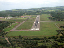
IATA: MKK – ICAO: PHMK – FAA LID: MKK Location of Airport in Hawaii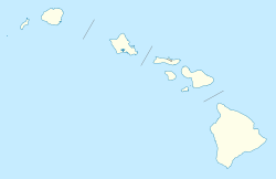
 MKK
MKKSummary Airport type Public Operator Hawaii Department of Transportation Serves Kaunakakai, Hawaii Elevation AMSL 454 ft / 138 m Coordinates 21°09′10″N 157°05′47″W / 21.15278°N 157.09639°WCoordinates: 21°09′10″N 157°05′47″W / 21.15278°N 157.09639°W Website Runways Direction Length Surface ft m 5/23 4,494 1,370 Asphalt 17/35 3,118 950 Asphalt Statistics (2010) Aircraft operations 40,716 Based aircraft 4 Source: Federal Aviation Administration[1] Molokai Airport (IATA: MKK, ICAO: PHMK, FAA LID: MKK) is a public airport located 6 NM (11 km; 6.9 mi) northwest of Kaunakakai,[1] on the island of Molokai in Maui County, Hawaii, United States. It is the principal airport of the island.
Contents
Facilities and aircraft
Molokai Airport occupies 288 acres (117 ha) at an elevation of 454 feet (138 m) above mean sea level on the central plateau of the island of Molokai. The airport has two asphalt paved runways that accommodate commuter/air taxi and general aviation activities, as well as some military flights: Runway 5/23 is 4,494 by 100 feet (1,370 x 30 m) and Runway 17/35 is 3,118 by 100 feet (950 x 30 m).[1]
The passenger terminal complex and general aviation facilities are north of the runway intersection; the passenger terminal complex is near the principal runway and the general aviation facilities are near the crosswind runway. Vehicular access to these two areas is provided by separate access roadways, each connecting with Keonelele Avenue.
For the 12-month period ending April 20, 2010, the airport had 40,716 aircraft operations, an average of 111 per day: 66% air taxi, 28% general aviation, 4% military, and 2% scheduled commercial. At that time there were 4 aircraft based at this airport, all single-engine.[1]
Airlines and destinations
Airlines Destinations Island Air Honolulu, Kahului, Kapalua, Lanai Mokulele Airlines Honolulu, Kahului Pacific Wings Honolulu, Kalaupapa Disasters
Aloha Island Air Flight 1712
On October 28, 1989, Aloha Island Air flight 1712, a de Havilland Canada DHC-6 Twin Otter aircraft, collided with mountainous terrain near Halawa Valley, Molokai, while en route on a scheduled passenger flight from Kahului Airport to Molokai Airport in Hoolehua.
The NTSB determined the cause of the accident was the airplanes controlled flight into terrain as a result of the decision of the captain to continue the flight under visual flight rules at night into instrument meteorological conditions, which obscured rising mountainous terrain.[2]
All 20 aboard the aircraft died. Thirteen of the victims were from Molokai, including eight members of the Molokai High School boys and girls volleyball teams and two faculty members. The girls team had just qualified on Maui for the state tournament.[3]
Media appearances
The mission "Hawaiian Checkout" supplied with Microsoft Flight Simulator X begins at Molokai Airport.
References
- ^ a b c d FAA Airport Master Record for MKK (Form 5010 PDF). Federal Aviation Administration. Effective 29 July 2010.
- ^ http://www.airdisaster.com/reports/ntsb/AAR90-05.pdf
- ^ Honolulu Star-Bulletin Local News
External links
- Hawaii DOT page for Molokai Airport
- FAA Airport Diagram (PDF), effective 20 October 2011
- FAA Terminal Procedures for MKK, effective 20 October 2011
- Resources for this airport:
- AirNav airport information for PHMK
- ASN accident history for MKK
- FlightAware airport information and live flight tracker for PHMK
- NOAA/NWS latest weather observations for PHMK
- SkyVector aeronautical chart for MKK
Airports in Hawaii Hawaii Island Oahu Kauai Maui Smaller islands Military Categories:- Airports in Hawaii
- Buildings and structures in Maui County, Hawaii
- Transportation in Maui County, Hawaii


Wikimedia Foundation. 2010.