- Naval Auxiliary Landing Field Ford Island
-
NALF Ford Island 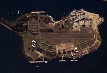
IATA: none – ICAO: PHNP – FAA LID: NPS Summary Airport type Military Owner US Navy Serves closed Location Honolulu County, Hawaii, USA Elevation AMSL 18 ft / 5.5 m Coordinates 21°21′53.616″N 157°57′35.119″W / 21.36489333°N 157.95975528°W Runways Direction Length Surface ft m 04/22 4,000 1,219 Asphalt Source: Federal Aviation Administration[1] Naval Auxiliary Landing Field Ford Island (NALF Ford Island) was a military use airport on the Island of Oahu, Hawaii, United States. Prior to 1962, it was designated as Naval Air Station Ford Island until its downgrade from NAS to NALF. It continues to be owned by the United States Navy and is located six nautical miles (11.1 km) northwest of the central business district of the City of Honolulu on Ford Island.[1] NALF Ford Island was closed as an active airfield on 1 July 1999, but still remains part of the Naval Base Pearl Harbor complex .[2]
Contents
Facilities
NALF Ford Island covers an area of 170 acres (69 ha) at an elevation of 18 feet (5.5 m) above mean sea level. It has one runway designated 04/22 with an asphalt surface measuring 4,000 by 150 feet (1,219 x 46 m). For the 12-month period ending 4 March 1998, the airport had 39,992 aircraft operations, an average of 110 per day: 98% general aviation and 2% military.[1] Although most U.S. airports use the same three-letter location identifier for the FAA and IATA, this airport was assigned NPS by the FAA[1] but has no designation from the IATA.[3].
History
 Ford Island in 1930.
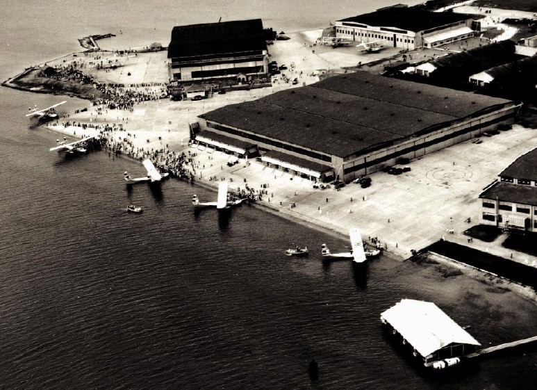
 P2Y-1s of VP-10F after their record setting flight at Ford Island, 1934.
U.S. military aviation on Ford Island started with the arrival of Captain John Curry, U.S. Army on 13 February 1914 to command the 6th Aero Squadron. This squadron was to be equipped with Curtiss N-9 seaplanes. Curry scanned Oahu for suitable facilities, choosing Ford Island, while selecting Fort Kamehameha as a temporary site for operations. “It (Ford Island) had excellent approaches and plenty of water for landings and take-offs. It faced into the prevailing wind and a land airdrome could be easily made. It was within the Red Hill line. It was the cheapest and most available land (really the only available land) that fulfilled all the requirements that we needed.”[4] Curry’s recommendations were approved locally and in Washington. Curry stated, “I then made the necessary arrangements with the owners, the John Ii Estate, for the purchase of the land and drew up plans for the establishment of a base that would accommodate several squadrons. Estimates amounting to about $1,300,000 were submitted for the establishment of the base and an additional sum of about $325,000 for the purchase of the Island.”[4] However, the sale was only finalized when Curry returned to the U.S. mainland in August 1917. The Oahu Sugar Company surrendered its leasehold to Ford Island in late 1917 to complete the sale. The War Department planned for both the United States Army and the United States Navy to use Ford Island. The 6th Aero Squadron moved to Ford Island on 25 September 1917 and began clearing the land for the first U.S. Army Air Service Station in Hawaii. In 1919, the station was officially named Luke Field, after Army Air Service fighter pilot, 2d Lieutenant Frank Luke who was killed in action over the Western Front during the First World War and posthumously awarded the Medal of Honor. Transfer of Luke Field, Hawaii to the U.S. Navy and its commissioning as NAS Ford Island released the "Luke Field" name, which the U.S. Army Air Corps (USAAC) subsequently applied to its new airfield near Phoenix, Arizona, which is the present day Luke AFB.
Naval Air Station Ford Island was commissioned in January 1923 and the runway completed in 1925. The large “Hangar 6” with its seaplane ramp became the most prominent building at NAS Ford Island. In 1935, the USAAC's 5th Composite Group operated pursuit planes and 66 Keystone bombers. By the end of the year Luke Field became that much overcrowded that the military negotiated a deal where the Navy operate from Ford Island, and the Army would construct a new air base across the harbour at what would become Hickam Field. By the end of 1940 the last U.S. Army had left Ford Island.[5]
The U.S. Navy primarily operated patrol seaplanes from NAS Ford Island. In addition, aircraft assigned to the Pacific Fleet’s carrier air groups were also flown to NAS Ford Island, when the carriers were inport at Pearl Harbor. Six U.S. Navy Consolidated P2Y-1s of patrol squadron VP-10F made a record-setting non-stop flight from San Francisco, California (USA), to NAS Ford Island on 10 January 1934, covering 3.861 km in 24:34 h.
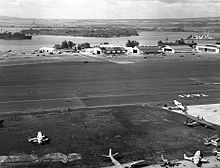 Operations at NAS Ford Island, 1939.
Amelia Earhart's first attempt to fly around the globe ended on Ford Island on 20 March 1937 when her Lockheed Electra 10E plane ground-looped on take-off. The circumstances of the ground loop remain controversial. Some witnesses at Luke Field said they saw a tire blow. Earhart thought either the Electra's right tire had blown and/or the right landing gear had collapsed. Some sources, cited pilot error. With the aircraft severely damaged, the flight was called off and the aircraft was shipped by sea to the Lockheed facility in Burbank, California for repairs.[6]
During the Japanese attack on Pearl Harbor on 7 December 1941, 33 of the 70 aircraft on the ground at Ford Island were destroyed. During the following war years the runway was extended and hangars and auxiliary buildings filled almost all available space. However, the confined space of NAS Ford Island and the need for longer runways for modern aircraft showed that the days of Ford Island as a Naval Air Station were numbered.
In 1939, the U.S. Navy began to build a new patrol airplane base at Kaneohe Bay, which would later be designated as NAS Kaneohe Bay. In 1942, Naval Air Station Barbers Point was also commissioned, which later became the main base for U.S. Navy fixed wing aviation. On 31 March 1962, Naval Air Station Ford Island was decommissioned and the installation downgraded to a Naval Auxiliary Landing Field (NALF) as part of the larger Peral Harbor complex.[7]
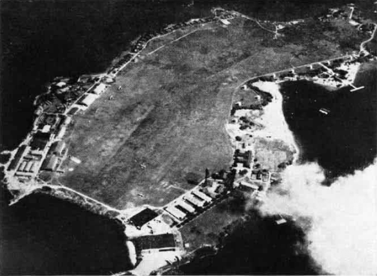
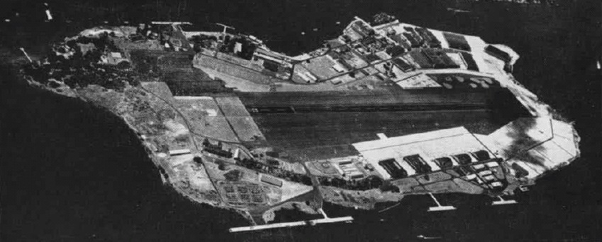
 NAS Ford Island in 1962.
On 20 February 1970, the 4,000 foot (1,200 m) runway at NALF Ford Island was opened to civilian flight training operations, primarily local Army, Navy, Air Force and Marine Corps military flying clubs. Itinerant military helicopter training activities also continued to be conducted at NALF Ford Island during this period. On 1 July 1999, all military and civilian general aviation activity at NALF Ford Island ceased when NAS Barbers Point was closed as a result of BRAC action and became the current civilian Kalaeloa Airport and Coast Guard Air Station Barbers Point.[4]
See also
- Hawaii World War II Army Airfields
References
- ^ a b c d FAA Airport Master Record for NPS (Form 5010 PDF), effective 1999.
- ^ http://www.airfields-freeman.com/HI/Airfields_HI_Oahu_S.htm
- ^ "PHNP - Honolulu, Oahu, Hawaii - Ford Island NALF". Great Circle Mapper. http://gc.kls2.com/airport/PHNP. Retrieved 2009-09-11.
- ^ a b c http://hawaii.gov/hawaiiaviation/hawaii-airfields-airports/oahu-pre-world-war-ii/ford-island
- ^ Stan Cohen: East Wind Rain. A Pictorial History of the Pearl Harbor Attack. Pictoral Histories Publishing Company, Missoula, Montana (USA), 1981, p. 20.
- ^ Leder, Jane. Amelia Earhart (Great Mysteries: Opposing Viewpoints). San Diego: Greehaven Press, Inc., 1989, p. 48. ISBN 0-89908-070-7.
- ^ http://www.history.navy.mil/nan/backissues/1960s/1965/Oct65.pdf
External links
- Resources for this airport:
- AirNav airport information for NPS
- SkyVector aeronautical chart for NPS
- History of NAS Ford Island
Airports in Hawaii Hawaii Island Oahu Kauai Maui Smaller islands Military Categories:- United States Naval Auxiliary Landing Fields
- Military facilities in Hawaii
- Transportation in Honolulu County, Hawaii
- Airfields of the United States Army Air Forces in Hawaii
- Closed facilities of the United States Navy


Wikimedia Foundation. 2010.