- Ford Island
-
For other uses, see Ford Island (disambiguation).
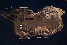
Ford Island is located in the middle of Pearl Harbor, Hawaii. It is connected to the main island by the Ford Island Bridge. Before the bridge was built, Ford Island could only be reached by a ferry boat which ran at hourly intervals for cars and foot passengers. The island houses several naval facilities. It also has four main groups of military housing: Nob Hill, Luke Field, Kamehameha Loop, and Battleship Cove. The United States Census Bureau defines Ford Island as Block 9014, Block Group 9, Census Tract 81 of Honolulu County, Hawaii. The island officially has 0.707 square miles (1.83 km2) of land and a population of 368 persons as of the 2000 census.[1]
Contents
History
Ancient Hawaiians called the island Moku ʻumeʻume—the isle of attraction.[2][3] It was named after Dr. Seth Porter Ford (1818–1866), a Boston physician who practiced medicine at the Hawaiian Insane Asylum and the US Seamen's Hospital from 1861–1866 after Charles Guillou.[4]
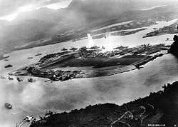
When Ford died, the island was sold to the Honolulu Plantation. The U.S. Army purchased it during World War I for US$236,000,[5] and stationed the 6th Aero Squadron there on September 25, 1918. On April 29, 1919, the field was named Luke Field, in memory of 2nd Lt. Frank Luke. It was transferred to the Navy in 1932. At the height of World War II more than 40,000 people lived and worked on the 450-acre (180 ha) island. The island was in the center of the Attack on Pearl Harbor, because of the battleship moorings surrounding the island.
From the 1940s through the 1990s, Presidents Franklin D. Roosevelt, John F. Kennedy and George H. W. Bush were guests at Ford Island.
The Naval Air Station Ford Island was decommissioned as a separate command in 1962 and placed under Naval Base Pearl Harbor control, but the former naval air station and airfield on Ford Island remained an uncontrolled naval auxiliary landing field for both military helicopters and military flying club aircraft until July 1, 1999. The island was declared a National Historic Landmark in 1964, and was listed in the National Register of Historic Places in 1976.
Several motion pictures were filmed on Ford Island, including In Harm's Way starring John Wayne, Tora Tora Tora, and the 2001 Michael Bay picture Pearl Harbor.
Before the Admiral Clarey Bridge was opened in 1998, transportation to and from Ford Island was by ferryboat. Tourists were unable to visit the island without a military ID or being invited by a resident. Now, civilians are able to visit the USS Missouri and Pacific Aviation Museum Pearl Harbor there.
Features
- There are monuments to the USS Utah and USS Oklahoma on the island.
- USS Missouri—which was the site of the Japanese surrender in WWII and was recalled into active duty for the Gulf War—is docked here.[6]
- Luke Field (est. 1919) is located here.
- Naval Auxiliary Landing Field Ford Island is located here.
- The Pacific Aviation Museum is located here. Currently, the museum, which opened on December 7, 2006, is housed in Hangar 37 and there are plans to expand the museum to Hangars 54 and 79.
References
- ^ Block 9014, Block Group 9, Census Tract 81, Honolulu County United States Census Bureau
- ^ Mary Kawena Pukui, Samuel Hoyt Elbert and Esther T. Mookini (2004). "lookup of Ford Island ". in Place Names of Hawai'i. Ulukau, the Hawaiian Electronic Library, University of Hawaii Press. http://wehewehe.org/gsdl2.5/cgi-bin/hdict?j=pp&l=en&q=Ford+Island&d=. Retrieved March 8, 2011.
- ^ Mary Kawena Pukui, Samuel Hoyt Elbert and Esther T. Mookini (2004). "lookup of Moku'ume'ume ". in Place Names of Hawai'i. Ulukau, the Hawaiian Electronic Library, University of Hawaii Press. http://wehewehe.org/gsdl2.5/cgi-bin/hdict?j=pp&l=en&q=Moku%27ume%27ume&d=. Retrieved March 8, 2011.
- ^ Gregg K. Kakesako (April 13, 1998). "Ford Island has a checkered, colorful past". Honolulu Star-Bulletin. http://archives.starbulletin.com/98/04/13/news/story2.html. Retrieved March 8, 2011.
- ^ John R. K. Clark (2004). "lookup of Ford Island ". in Hawai'i Place Names: Shores, Beaches, and Surf Sites. Ulukau, the Hawaiian Electronic Library, University of Hawaii Press. http://wehewehe.org/gsdl2.5/cgi-bin/hdict?j=cl&l=en&q=Ford+Island&d=. Retrieved March 8, 2011.
- ^ See also: Joint Base Pearl Harbor-Hickam #USS Missouri.
External links
- Pearl Harbor Raid, 7 December 1941 — Attacks off the West Side of Ford Island
- Burning barracks at Ford Island
Coordinates: 21°21′50″N 157°57′37″W / 21.36389°N 157.96028°W
Categories:- Landforms of Oahu
- Islands of Hawaii
- Military facilities in Hawaii
- Attack on Pearl Harbor
- Honolulu County, Hawaii
Wikimedia Foundation. 2010.


