- Mokulēʻia, Hawai'i
-
Mokuleia, Hawaii — CDP — Location in Honolulu County and the state of Hawaii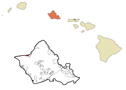
Country United States State Hawaii Counties Honolulu Area – Total 5.1 sq mi (13.2 km2) – Land 2 sq mi (5.2 km2) – Water 3.1 sq mi (8 km2) Population (2000) – Total 1,839 – Density 360.6/sq mi (139.3/km2) Mokulēʻia is a North Shore community and census-designated place (CDP) in the Waialua District on the island of Oʻahu, City & County of Honolulu, Hawaiʻi. Mokulēʻia means isle (of) abundance in Hawaiian. As of the 2000 Census, the CDP had a total population of 1,839. Features of interest here include Mokulēʻia Beach, Mokulēʻia Polo Field, and Dillingham Airfield located west of the town.
At the western end of Farrington Highway, approximately 1 mile beyond Dillingham Airfield entrance, begins the track (trail) to Kaʻena Point, the western-most tip of Oʻahu.
The U.S. postal code for Mokulēʻia is 96791.
Geography
Mokulēʻia is located at 21°34′57″N 158°10′31″W / 21.5825°N 158.17528°W (21.582523, -158.175141),[1] immediately west of Waialua along Farrington Highway and State Rte. 82 (Waialua Beach Road).
According to the United States Census Bureau, the CDP has a total area of 5.1 square miles (13 km2), of which, 2.0 square miles (5.2 km2) of it is land and 3.1 square miles (8.0 km2) of it (60.98%) is water.
Demographics
As of the Census of 2000, there were 1,839 people, 709 households, and 384 families residing in Mokulēʻia. The population density was 923.2 people per square mile (356.8/km²). There were 883 housing units at an average density of 443.3 per square mile (171.3/km²). The racial makeup of the CDP was 57.21% White, 1.47% Black or African American, 0.27% Native American, 11.36% Asian, 5.60% Pacific Islander, 0.60% from other races, and 23.49% from two or more races. 7.29% of the population were Hispanic or Latino of any race.
There were 709 households out of which 25.7% had children under the age of 18 living with them, 37.8% were married couples living together, 11.4% had a female householder with no husband present, and 45.7% were non-families. 31.3% of all households were made up of individuals and 2.5% had someone living alone who was 65 years of age or older. The average household size was 2.38 and the average family size was 3.04.
In the CDP the population was spread out with 21.5% under the age of 18, 16.1% from 18 to 24, 36.1% from 25 to 44, 20.3% from 45 to 64, and 6.0% who were 65 years of age or older. The median age was 30 years. For every 100 females there were 134.0 males. For every 100 females age 18 and over, there were 139.7 males.
The median income for a household in the CDP is $50,100, and the median income for a family is $57,917. Males have a median income of $36,458 versus $27,317 for females. The per capita income for the CDP is $24,643. 10.7% of the population and 10.5% of families are below the poverty line. Out of the total population, 15.1% of those under the age of 18 and 7.8% of those 65 and older are living below the poverty line.
References
- ^ "US Gazetteer files: 2010, 2000, and 1990". United States Census Bureau. 2011-02-12. http://www.census.gov/geo/www/gazetteer/gazette.html. Retrieved 2011-04-23.
Municipalities and communities of Honolulu County, Hawaii CDPs Ahuimanu | Aiea | 'Ewa Beach | 'Ewa Gentry | Ewa Villages | Halawa | Hale'iwa | Hau'ula | He'eia | Honolulu | Iroquois Point | Kaʻaʻawa | Kahaluu | Kahuku | Kailua | Kalaeloa | Kaneohe | Kawela Bay | Laie | Mā'ili | Mākaha | Mākaha Valley | Makakilo | Marine Corps Base Hawaii | Maunawili | Mililani | Mokulē'ia | Nānākuli | North Ko'olaupoko | Pearl City | Punalu'u | Pūpūkea | Schofield Barracks | Village Park | Wahiawā | Waialua | Wai'anae | Waimalu | Waimanalo Beach | Waimānalo | Waipahu | Waipi'o Acres | Waipio | Whitmore Village

Unincorporated
communitiesAina Haina | Hawaii Kai | Kaimuki | Kapolei | Kunia Camp | Palolo | Pauoa | Waimea Bay
Categories:- Neighborhoods in Honolulu, Hawaii
- Census-designated places in Honolulu County, Hawaii
- Populated places on Oahu


Wikimedia Foundation. 2010.