- North Ko'olaupoko, Hawai'i
-
Waikane, Hawaii — CDP — Location in Honolulu County and the state of Hawaii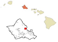
Country United States State Hawaii Counties Honolulu Area - Total 7.2 sq mi (18.6 km2) - Land 6.8 sq mi (17.7 km2) - Water 0.4 sq mi (0.9 km2) Population (2000) - Total 726 - Density 100.8/sq mi (39/km2) North Koʻolaupoko is a census-designated place (CDP) in the City & County of Honolulu, Hawaii, United States, on the island of Oʻahu. The population was 726 at the 2000 census. In Hawaiian, koʻolau poko means "short windward", referring to the fact that this is the shorter of the two windward districts on the island (Koʻolauloa or "long windward" is the other). Koʻolaupoko extends from Makapuʻu Point on the southeast to Kaʻōʻio Point on the north. Included within the district are the largest windward towns of Kāneʻohe, Kailua, and Waimānalo—places discussed in separate articles.
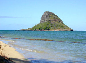 Mokoliʻi Islet, popularly known as Chinaman's Hat, at the north end of Kāneʻohe Bay, seen here from the south shore of Kualoa Beach Park.
North Koʻolaupoko lies mostly along the coastline of Kāneʻohe Bay and consists of several lush valleys that extend inland to the steep face of the Koʻolau pali (cliff). The first valley north of Kahaluʻu is Waiāhole. Next is Waikāne, then Hakipuʻu, and northernmost is Kualoa. This area differs from the towns, valleys, and ahupuaʻa of the southern part of Koʻolaupoko in that it is mostly undeveloped, decidedly rural in character, with many small farms.
Despite the long shoreline, public access to Kāneʻohe Bay is somewhat limited by private holdings. A small community park at Waiāhole is being enlarged and improved (2003). A larger City & County park at Kualoa provides camping and picnic areas, a long narrow beach, and views of Mokoliʻi Islet (Chinaman's hat). The south side of Kualoa Beach Park faces onto Kāneʻohe Bay and the east shore is a fringing reef off the Pacific Ocean coast of northeast Oʻahu.
The U.S. postal code for all of North Koʻolaupoko is 96744 (the same as Kāneʻohe).
Contents
Geography
Waikāne is located at 21°29'47" North, 157°51'34" West (21.496355, -157.859321)[1]. Southward along the shore of Kāneʻohe Bay via Kamehameha Highway (State Rte. 83) are (from Waikāne): Waiāhole and Kahaluʻu. Northwest up the coast beyond Kualoa and Kaʻōʻio Point is the town of Kaʻaʻawa.
Although data are collected under the United States Census Bureau tract called "Waikane", the tract encompasses much more than the place known as Waikāne, which is but one of several valleys comprising the north end of the Koʻolaupoko District. The census tract has a total area of 7.2 square miles (18.6 km²), of which, 6.8 square miles (17.7 km²) of it is land and 0.3 square miles (0.9 km²) of it is water. The total area is 4.88% water.
Demographics
As of the 2000 census, there were 726 people in the northern part of the Koʻolaupoko District, with 188 households and 156 families residing in the census tract. The population density was 106.4 people per square mile (41.1/km²). There were 198 housing units at an average density of 29.0 per square mile (11.2/km²). The racial makeup of the tract was 16.94% White, 0.14% Black or African American, 0.28% Native American, 19.15% Asian, 22.45% Pacific Islander, 1.79% from other races, and 39.26% from two or more races. 5.10% of the population were Hispanic or Latino of any race.
There were 188 households out of which 32.4% had children under the age of 18 living with them, 59.0% were married couples living together, 14.4% had a female householder with no husband present, and 16.5% were non-families. 11.2% of all households were made up of individuals and 4.3% had someone living alone who was 65 years of age or older. The average household size was 3.86 and the average family size was 4.09.
In the CDP the population was spread out with 28.1% under the age of 18, 8.1% from 18 to 24, 26.9% from 25 to 44, 27.4% from 45 to 64, and 9.5% who were 65 years of age or older. The median age was 34 years. For every 100 females there were 96.2 males. For every 100 females age 18 and over, there were 94.8 males.
The median income for a household in the CDP was $55,179, and the median income for a family was $53,625. Males had a median income of $31,786 versus $25,313 for females. The per capita income for the tract was $15,592. 11.6% of the population and 4.3% of families were below the poverty line. Out of the total population, 16.1% of those under the age of 18 and 2.0% of those 65 and older were living below the poverty line.
References
- ^ "US Gazetteer files: 2010, 2000, and 1990". United States Census Bureau. 2011-02-12. http://www.census.gov/geo/www/gazetteer/gazette.html. Retrieved 2011-04-23.
External links
Municipalities and communities of Honolulu County, Hawaii County seat: Honolulu CDPs Ahuimanu | Aiea | 'Ewa Beach | 'Ewa Gentry | Ewa Villages | Halawa | Hale'iwa | Hau'ula | He'eia | Honolulu | Iroquois Point | Kaʻaʻawa | Kahaluu | Kahuku | Kailua | Kalaeloa | Kaneohe | Kawela Bay | Laie | Mā'ili | Mākaha | Mākaha Valley | Makakilo | Marine Corps Base Hawaii | Maunawili | Mililani | Mokulē'ia | Nānākuli | North Ko'olaupoko | Pearl City | Punalu'u | Pūpūkea | Schofield Barracks | Village Park | Wahiawā | Waialua | Wai'anae | Waimalu | Waimanalo Beach | Waimānalo | Waipahu | Waipi'o Acres | Waipio | Whitmore Village

Unincorporated
communitiesAina Haina | Hawaii Kai | Kaimuki | Kapolei | Kunia Camp | Palolo | Pauoa | Waimea Bay
Categories:- Neighborhoods in Honolulu, Hawaii
- Census-designated places in Honolulu County, Hawaii
- Populated places on Oahu


Wikimedia Foundation. 2010.