- Nes Harim
-
Nes Harim 
Founded 1950 Founded by Kurdish and Moroccan immigrants Council Mateh Yehuda Region Judean foothills Affiliation Moshavim Movement Coordinates 31°44′41.28″N 35°3′29.88″E / 31.7448°N 35.0583°ECoordinates: 31°44′41.28″N 35°3′29.88″E / 31.7448°N 35.0583°E 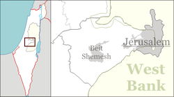
 Nes Harim
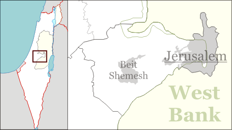
Nes Harim (Hebrew: נֵס הָרִים, lit. Mountain Miracle) is a moshav in Israel, eight kilometers from Jerusalem. [1]Located in the Judean foothills near Beit Shemesh, it falls under the jurisdiction of Mateh Yehuda Regional Council. In 2006 it had a population of 588.
The moshav was established in 1950 by immigrants from Kurdistan and Morocco,[2] on the land of the Palestinian village Bayt 'Itab, which was depopulated in the 1948 War.[3]
It is situated 2,275 feet (700 meters) above sea level. The early farmers planted orchards and vineyards, taking advantage of the fertile soil and unique climate.[4]
The ruins of a Byzantine monastery were discovered on a hill on the southwest side of the moshav.[5]
The Katlav winery is located in Nes Harim.[6]
Archaeology
During excavations in November 2008, archaeologists found the narthex of a church decorated with multicolored mosaics,and parts of a wine press. After the discovery, the mosaic was badly damaged by unidentified vandals.[7]
The mosaic includes an inscription in ancient Greek deciphered by Leah Di Signi of the Hebrew University of Jerusalem: "O Lord God of Saint Theodorus, protect Antonius and Theodosia the illustres [a title used to distinguish high nobility in the Byzantine period] - Theophylactus and John the priest [or priests]. [Remember o Lord] Mary and John who have offe[red - ] in the 6th indiction. Lord, have pity of Stephen."[8]
Horbat 'Itab, a 130-dunam national park on the outskirts of Nes Harim, contains the ruins of a Crusader fortress that overlooked the road from Emek HaEla to Jerusalem and the village of Bayt 'Itab. The site was surveyed in 1989 by Denys Pringle, a researcher of the Crusader period, who documented the remains of the fortress, vaults, a wall and towers, tunnels, a columbarium and an olive press. [9]
References
- ^ Farmers find monastery beneath Israeli soil CNN.com, 3/11/2009
- ^ Nes Harim history
- ^ All That Remains: The Palestinian Villages Occupied and Depopulated by Israel in 1948, Walid Khalidi, 1992, Washington D.C., Institute for Palestine Studies, ISBN=0887282245, p. 275
- ^ Nes Harim history
- ^ Farmers find monastery beneath Israeli soil CNN.com, 3/11/2009
- ^ Nes Harim history
- ^ Nes Harim church and wine press
- ^ Nes Harim church and wine press
- ^ Conservation-engineering stabilization
Mateh Yehuda Regional Council Kibbutzim Harel · Kiryat Anavim · Ma'ale HaHamisha · Nahshon · Netiv HaLamed-Heh · Ramat Rachel · Tzora · TzovaMoshavim Aderet · Agur · Aminadav · Aviezer · Bar Giora · Beit Zayit · Beit Meir · Beit Nekofa · Bekoa · Eshtaol · Even Sapir · Gefen · Giv'at Ye'arim · Givat Yeshayahu · Kfar Uria · Ksalon · Luzit · Mevo Beitar · Mata · Mahsia · Mesilat Zion · Naham · Nehusha · Nes Harim · Neve Ilan · Neve Michael · Ora · Ramat Raziel · Sdot Micha · Sho'eva · Shoresh · Ta'oz · Tal Shahar · Tarum · Tirosh · Tzafririm · Tzelafon · Yad HaShmona · Yish'i · Zanoah · ZekhariaCommunal settlements Jewish villages Arab villages Other villages Categories:- Mateh Yehuda Regional Council
- Moshavim
- Populated places established in 1950

Wikimedia Foundation. 2010.