- Districts of the Northwest Territories
-
The vastness of Canada's Northwest Territories (spelled 'North-West Territories' from 1870 to 1905) meant that for much of its history it was divided into several districts for ease of administration. The number and size of these territorial districts varied as other provinces and territories of Canada were created and expanded. The districts of the Northwest Territories were abolished in 1999 with the creation of Nunavut territory and the contraction of the Northwest Territories to its current size.
Contents
North-West Territories pre-'districts'
The North-West Territories were administered as a single entity, with no districts, from 1870 to 1882.
In 1870 Canada gained control of the Rupert's Land and the North-Western Territory from the Hudson's Bay Company. That same year, a small piece of Rupert's Land was formed into the province of Manitoba, but the rest of the area was merged and renamed the North-West Territories. This region included the vast bulk of Canada's present day landmass and covered an area about the size of western Europe.
In 1876 the North-West Territories contracted in size when a large area of 590,932 km2 (228,160 sq mi), between Manitoba and Ontario and along the entire west coast of Hudson Bay, was established by Canada as a territory named the District of Keewatin. This autonomous territory is not to be confused with the 'districts' which would later be created within the North-West Territories.
In 1880 the Canadian Arctic Archipelago was ceded to Canada by the United Kingdom and this land was added to the North-West Territories.
1882
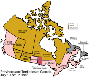

As the southern part of the North-West Territories became populated, four districts were created in 1882 for ease of administration; unlike Keewatin, these areas remained a part of the North-West Territories, and thus were formally called provisional districts[1]:
- The District of Alberta was where the southwestern part of the province of Alberta is today, east of British Columbia, west of the line between ranges 10 and 11 of the Dominion Land Survey (about 112° west) and north of the American border.
- The District of Athabasca covered the northern half of what is today Alberta.
- The District of Assiniboia was where the southernmost quarter of Saskatchewan is today (south of the Ninth Correction Line, about 51.97° north), but stretched somewhat further west into what is today Alberta.
- The District of Saskatchewan was to the north of Assiniboia extending halfway up modern Saskatchewan. It stretched further east than Assiniboia, running all the way to the shore of Lake Winnipeg and the Nelson River. It also stretched west into what is now Alberta.
1895
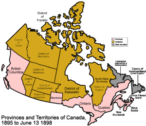
In 1895 the northern portion of the North-West Territories was divided into four more internal districts for ease of administration.[2][3]:
- The District of Franklin was made up of the Arctic islands.
- The District of Ungava was made up of what is today northern Quebec
- The District of Yukon was made up of what is today the Yukon.
- The District of Mackenzie was the rest, stretching from the Yukon border in the west to the Keewatin border in the east, and containing none of the islands.
- The District of Athabasca expanded and covered the northern half of what is today both Alberta and Saskatchewan.
1898
The North-West Territories shrunk in 1898 when the Klondike Gold Rush necessitated the conversion of the District of Yukon into the autonomous Yukon Territory.
1905
The North-West Territories experienced significant adjustments in 1905:
- The Districts of Alberta, Assiniboia, Athabaska, and Saskatchewan were reorganized to form the provinces of Alberta and Saskatchewan.
- The original independent territory 'District of Keewatin', which had shrunk considerably from its 1876 size as large portions of its area had been converted into the expansion of Manitoba and Ontario, gave up its autonomy and became a district within the North-West Territories.
- A small eastern portion of the (now) defunct Districts of Saskatchewan and Athabaska were added to the District of Keewatin.
- A portion of the District of Mackenzie was added to the District of Keewatin.
- The hyphen was removed from North-West Territories, so that the area was now named the Northwest Territories.
- The Northwest Territories now consisted of the Districts of Franklin, Ungava, Mackenzie and Keewatin.
1912
The Northwest Territories experienced further attrition in 1912:
- The entire District of Ungava was converted into the northern expansion of the province of Quebec
- Most of the District of Keewatin was converted into the northern expansion of the provinces of Ontario and Manitoba.
- The Northwest Territories now consisted of the Districts of Franklin, Mackenzie and Keewatin.
The three remaining districts continued to be used for a number of decades, but as control over the territory was moved from departments of the federal government to a centralized government in Yellowknife, they began to have far less use. Although the Districts of Franklin, Mackenzie and Keewatin continued to appear on many maps, the governance of the Northwest Territories was divided into four administrative regions: Inuvik, Fort Smith, Keewatin and Baffin. A fifth region, the Central Arctic Region and subsequently called the Kitikmeot, was later carved out of the Fort Smith Region.
1999
In 1999 the Northwest Territories was reduced to its current size - and the notion of the 'districts' was abolished - with the creation of the Canadian territory of Nunavut. The former District of Keewatin, most of the Arctic Islands of the District of Franklin, and a northwest portion of the District of Mackenzie now form Nunavut, with the remainder of Franklin and the majority of Mackenzie forming the current version of the Northwest Territories.
See also
- Former colonies and territories in Canada
- Territorial evolution of Canada
- Politics of Northwest Territories
- History of the Northwest Territories
- History of Northwest Territories capital cities
- Council of Keewatin
- List of Northwest Territories Legislative Assemblies
Notes
- ^ Fung, Professor of Geography, University of Saskatchewan., Dr. K.I.; Richards,, J. Howard, Evolution-boundaries-1882: (1969). Atlas of Saskatchewan. Saskatoon: Modern Press., http://www.rootsweb.com/~cansk/maps/evolution-boundaries-1882.html, retrieved 2007-10-12
- ^ Fung, Professor of Geography, University of Saskatchewan., Dr. K.I.; Richards,, J. Howard, Evolution-boundaries-1895: (1969). Atlas of Saskatchewan. Saskatoon: Modern Press., http://www.rootsweb.com/~cansk/maps/evolution-boundaries-1895.html, retrieved 2007-10-12
- ^ The Atlas of Canada - Territorial Evolution, 1895, http://atlas.nrcan.gc.ca/site/english/maps/historical/territorialevolution/1895, retrieved 2007-10-12
External links
- A map of the districts of the Northwest Territories
- NWT Historical Timeline
- History of the name of the Northwest Territories
History of the Northwest Territories Capital cities • Culture • Districts • Economy • Elections • Evolution • Flag • Geography • Governance • Languages • Legislature • Politics
 Former colonies and territories in Canada
Norse French Claims: New France (Acadia • Isle St-Jean • Île Royale • Canada • Terre Neuve) Important sites: Port Royal • Quebec •Trois-Rivières • Montreal • Louisbourg • Plaisance• List of towns • List of FortsSpanish Scottish Russian Claims: Russian AmericaAmerican Claims: Oregon CountryEnglish &
BritishClaims: Rupert's Land • Nova Scotia (1710) • Quebec • Lower and Upper Canada • New Brunswick • Prince Edward Island • Cape Breton • United Canada • New Caledonia • Columbia District • Colony of the Queen Charlotte Islands • Colony of Vancouver Island • Colony of British Columbia • Stickeen Territories • North-Western Territory • Red River Colony • United Colonies of Vancouver Island and British Columbia • Important sites: Cuper's Cove • York Factory • Halifax • Victoria • Fort Langley • List of HBC sitesNorway Claims: Sverdrup IslandsRelated


Wikimedia Foundation. 2010.