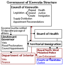
- Council of Keewatin
-
Council of Keewatin Type Type Unicameral Timeline Established November 25, 1876 Disbanded April 16, 1877 Members 6 Election Last election Members chosen by appointment November 25, 1876. Meeting place Fort Garry[B] The Council of Keewatin was an unelected legislative body and territorial government for the now-defunct District of Keewatin in Canada. The District of Keewatin was created by the passage of the Keewatin Act on April 12, 1876[1] from a portion of Canada's North West Territories.[A] Lieutenant Governor Alexander Morris convinced the government that the new territorial government of the North West Territories would be unable to effectively administer land to the north and east of Manitoba.[1] Shortly after the District of Keewatin was formed a large group of Icelanders arrived, infected with smallpox which quickly spread to the indigenous First Nation population. The Government of Canada allowed the Council to be formed for the purpose of containing the smallpox epidemic.[H] The Council also administered Indian treaty claims, immigrant land claims, Hudson's Bay Company trading post concerns as well as policing and health care. The Council lasted from November 25, 1876, until April 16, 1877, after which control of the territory was returned under federal jurisdiction.
 The Structure and Powers of the Government of Keewatin
The founder of the Council of Keewatin as well as the District of Keewatin was Alexander Morris. He selected and appointed the members to serve after being given permission by the Government of Canada. After the Council was disbanded in 1877, the legislation passed and departments organized by the council, such as the Boards of Health and Quarantine, continued to remain in force as late as 1878. The council was not reconstituted before the District of Keewatin was ceded back to the Northwest Territories in 1905.[A] All matters of administration were handled by the Government of Canada and the Lieutenant Governor of Manitoba.
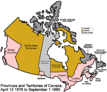 Map of Canada showing the District of Keewatin in 1876 (light blue).
Contents
Location
The new district of Keewatin was separate from the North West Territories, Canada. Keewatin was an area extending north of the "postage stamp" province of Manitoba, and the Canada – United States border to the northern shores of Canada. To the west was the North-West Territories, to the east Ontario and again the North-West Territories. The Lieutenant Governor of Manitoba, Alexander Morris, served exofficio as Lieutenant Governor of the district.[2][G]
History
Treaty 5 land negotiations
Morris had fully expected the Sandy Bar Saulteaux to sign Treaty 5, The Lake Winnipeg Treaty in 1875.[3]:[698][4] The purpose of the treaty would be to free up lands for immigration, and settlement which are presently inhabited by the first nations people. In return the first nations would be granted reserve land, $5.00 per person annual payment, two oxen, one bull and four cows for each band, an annual payment of $50.00, salary for the Chief and three executive officers amounting to $70.00 total, as well as agricultural implements.[C] The Chief also received a flag and medal.[5][D]
Icelandic land grant
Icelanders emigrated from Iceland due to volcanic eruptions, shortage of grasslands, as well as a population increase which limited access to resources.[6] Canada was enticing immigrants with land to settle western Canada in this era. Lord Dufferin, Governor General of Canada,[7] and Lieutenant Governor Alexander Morris granted the Icelanders territory at Sandy Bar south of the Icelandic River. Between 235[8] and 285[3] Icelanders arrived at Willowpoint near Gimli on October 21, 1875, later that summer 1,200 new immigrants from Iceland joined them.[9] The Icelandic settlers elected a provisional town council of five members for the colony administration. The Dominion Government granted free transportation within Canada and settlement rights for a reserve known as New Iceland (Nýja Ísland),[10] established by an order-in-council.[11][12] 27,000 acres (110 km2) was set aside for the New Iceland territory,[13] which comprised 57.9 kilometres (36.0 mi) astride the western shore of Lake Winnipeg between Boundary Creek and White Mud River (Icelandic River) inclusive of Big Island (Hecla Island).[Map][9][14] The Icelanders were promised local self government, laws and judicial system and maintenance of their own school system by the Canadian government as well.[6][8][10][12] The Icelanders received a loan which was offered to the settlement in stages. $15,000 was allotted to the first arrivals of 1875. Then to the summer immigrants, a loan of $5,000 was extended to cover the cost of tickets, and $8,000 for agricultural tools and provisions. An extra $9,000 was paid to cover travel costs and three months provisions. $25,000 was received in April which was used for seed and livestock, of which 250 head of cattle were purchased. October saw another loan of $18,000 for winter provisions, and 100 cows. Altogether, $80,000 was loaned to the Icelandic settlers, of which the 160 acres (65 ha) of settlement lands per settler was used as collateral.[15][F] Their local council was dissolved April 12, 1876, when the District of Keewatin was established by the Dominion Government under the North-West Territories Act. At this same time the territory of New Iceland underwent an official transfer to the District of Keewatin.[9]
Land claim dispute
A land claim dispute arose between the Saulteaux family of John Ramsay and the Icelandic family Ólafur Ólafsson. The Saulteaux believed the boundary line between the settlements was at the south shore of the river. Ólafur Ólafsson constructed his cagin on the river's north shore. J.A.N. Provencher supported Ólafsson. Ramsay brought his claim to Morris. Ramsay had recently lost his wife and four of his five children to smallpox and wanted the Saulteaux title to be recognized. The surveyor general and the Indian Affairs Department deputy superintendent both agreed Ramsay had entitlement to the land under the Indian Act.[3]:[701] Treaty 5 was not signed by the Sandy Bar Saulteaux until 1876 after all appeals to federal agents regarding land claims failed.[3]:[698]
Smallpox
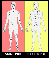
The District of Keewatin had a severe epidemic of smallpox that started shortly after the territory's creation in the settlements of Gimli and Sandy Bar.[16] The disease originated from a large group of Icelandic settlers that settled on the west shore of Lake Winnipeg.[17] The Icelanders thought the first appearance of the epidemic was chickenpox and so it was not recognized as a deadly smallpox epidemic.[9][12] The epidemic quickly spread to the local native population who were the predominate inhabitants of the territory.[16]
Council formation
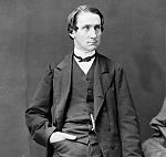 Alexander Morris, founder of both the District and the Council of Keewatin
The Council of Keewatin was created and its first and only members were appointed and sworn in on November 25, 1876, by Lieutenant Governor Alexander Morris.[18] Morris sent word to Ottawa by telegraph on November 24, 1876, asking for permission to setup the Council. The federal government responded quickly, allowing appointments and a proclamation to be printed the next day.[16] Members appointed to the Legislative Council were entitled to use the prefix The Honourable for the duration of their appointments.[19] The first session of the Council opened on November 30, 1876, with Morris delivering the first and only throne speech. In his throne speech Morris emphasized the impending need for the council to deal with the smallpox epidemic that was inflicting the fledgling territory.[1] The throne speech detailed the history of the Temporary North-West Council, why the District of Keewatin was created, and outlined the powers that were made available to the members comprising the Council of Keewatin.[1]
Council of Keewatin Members Alfred Codd, M.D. William Hespeler Albert G. Jackes, M.D. Gilbert McMicken Joseph Provencher Lieut.Col. Osborne Wm. Smith The council sat in Fort Garry, Manitoba despite being outside of the boundaries of the District of Keewatin. Morris determined during the creation of the territory that the affairs of the District of Keewatin should be administered from Fort Garry until November 7, 1876.[1] A total of six members were appointed to the Council. The law that created the territory allowed for a minimum of five members.[20]
William Hespeler was appointed to serve on the Executive Council as a cabinet minister serving Lieutenant Governor Morris. His portfolio gave him the title of Territorial Immigration Agent.[18] This office was needed to put measures and people in place to control access by settlers in the territory to help quarantine the smallpox epidemic.
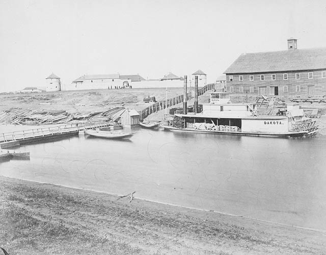
 Fort Garry, Manitoba
The other members of the council were all chosen for their medical knowledge rather than a political background.[1] The Council met at Early Government House in Fort Garry, which also served as the home for Alexander Morris.[21] The first and only clerk and secretary appointed to serve the council was F.G. Becher.[21] The Council chose William Osborne Smith to chair the proceedings of the Council as well as the Board of Health.[1]
Emergency quarantine
Fearing the disease would spread to Manitoba and the North West Territories, Morris advised the Department of the Interior that a territorial government needed to be setup to deal with the crisis.[1] Morris appointed Dr. Lynch to care for the Saulteaux smallpox epidemic.[22] Sigtryggur Jonasson visited John Taylor to seek help, returning to New Iceland November 8, 1877.[22] Drs. David Young, James S. Lynch, and A. Baldwin arrived to New Iceland placing the area under quarantine as of November 27, 1876.[23][24]
A hospital was established in Gimli, Keewatin and a quarantine station at Netley Creek.[2][15] The Grassy Narrows House, a Hudson’s Bay “outpost" also became an emergency hospital during the epidemic.[25] The nearby Sandy Bar Band first nation community at Riverton[26] was reached by Lynch and Young, and had been abandoned. The buildings were burned to contain the smallpox epidemic. Following the trail, they found the remaining 17 residents of the Sandy Bar band of about 60 people.[22] The Sandy Bar Band fled to the east shore of Lake Winnipeg. This had the effect of infecting any bands living there spreading the smallpox epidemic. Ramsay guided the doctor to the various bands. At Sandy River 200 persons were discovered dead. The Hudson's Bay Company warehouse, houses and teepees were all burned.[26]

After the throne speech was read on November 30, 1876, the council of Keewatin got to work quickly and passed its first piece of legislation. The Act was entitled An Act respecting Small Pox, and it served as the centre piece of the council. The act defined penalties and provisions to enforce Morris' proclamation on outlawing intercourse by people outside the infected zone who did not have permission from the Council. The Act and also offered advice and procedures for medical treatment of the disease.[1] For the entire span of the Council, all acts and regulations passed were geared towards dealing with smallpox.[27] Everyone who wanted to do business with or visit the infected areas had to obtain permission from the council.[21]
By April 1877, the small pox epidemic abated, however the quarantine remained until June 20, 1877.[2] The Icelanders demonstrated to Netley Creek, the southern border of New Island,[28] requesting an end to the quarantine, which had been lifted the previous day, June 19.[9] Of the 1,200 Icelandic settlers, 102 of them died of the Smallpox epidemic. Many of the immigrants had been previously immunized in Iceland before the trip to Canada.[22]
The fur trade
 Hudson Bay Post on Lake Winnipeg
During the short existence of the Council, it became involved with regulating the fur trade. The Council feared furs contaminated with smallpox would be exported outside the quarantine zone. The Council invited people involved in the fur trade from Keewatin, Manitoba, and even the United States government to discuss the matter. The purpose of the meeting was to solicit testimony and gain support of the industry, in order that the Council could effectively draft, implement and enforce legislation.[29]
The Council passed an act on February 26, 1877, which was subsequently given Royal Assent. The measures adopted effectively quarantined furs from areas of the district deemed infected and prevented their export. However, furs from areas in the District of Keewatin deemed to be free of smallpox could be exported as long as they did not come into contact with infected furs.[29]
All furs before being exported from the district had to pass through depots manned by a quarantine officer appointed by the Board of Health. Any furs believed to have come into contact with parts of the district infected by smallpox were to be destroyed.[29] This led to some problems for the Government of Canada after the Council was dissolved. Some persons affected by having their furs destroyed by the regulations applied to the Government to have compensation for lost property, as no mechanism was put in place when the act was drafted. Claims for compensation were effectively considered, delayed and ultimately ignored.[30]
The Hudson's Bay Company lost a full year in the northern fur trade and therefore pressed for further steps to be taken to prevent another smallpox outbreak. Dr. D.W.J. Hagarty was appointed as medical superintendent of the Manitoba and North-West Superintendencies in October 1878. His mission was to vaccinate all Native person resident in the Manitoba Superintendency. Every spring vaccinations were initiated to the population that was not away hunting.[23]
Board of Health
The Council of Keewatin established a powerful Board of Health for the territory. The Board of Health was run out of a head office within the city of Winnipeg[B] and a local office was also established resident within the District of Keewatin at the town of Gimli.[9]
The Board of Health was led by Chief Health Officer Walter R. Nursey. All matters regarding quarantine within the district were handled by Edmund A. Struthers.[31] The board was established to confine and treat the smallpox epidemic in the territory, and had broad powers available at its disposal to carry out the mission.[31] The Board of Health established vaccination programs among native populations in the District of Keewatin based on legislation that continued well after the life span of the Council.[32] Mr. Nursey was despatched by Governor Morris in February 1877 with a quarantine party to Lake Winnipeg to establish a northern quarantine and sanitary cordon between the City of Winnipeg and the infected area. This party was to regulate the trafficking in fur as well. The party arrived at Dog Head outpost in May 1877, having travelled the winter months by foot. There were no supplies, money or instruction on arrival. The quarantine party returned to Winnipeg in July 1877 half starved.[33]
Dissolution
The council was short-lived, producing only a single legislative session in its history. Less than a year after its formation, the smallpox crisis in the District of Keewatin subsided. The Department of the Interior determined a territorial government for the district was no longer needed. The entire council resigned and was effectively dissolved after being requested to do so on April 16, 1877, by Secretary of State James Aikins.[27] Aikins had the council resign as a cost saving measure, he also did not want members of the council to abuse the powers of their appointments.[27]
Control of the District of Keewatin returned to the federal government under the management of the Department of the Interior in cooperation with the Lieutenant Governor of Manitoba.[27] The council was not reconstituted before the remaining portions of the territory were once again merged with the Northwest Territories in 1905. The land formally comprising the territory is today governed by the provincial and territorial governments of Ontario, Manitoba and Nunavut.[34]
Debate of the Senate of the Dominion of Canada
On February 25, 1878, the Honourable Mr. Girard presented to His Excellency the Governor-General the correspondence between the Government of Canada, the Council of Keewatin, and the Government of Manitoba regarding the Small-Pox disease claims and accounts. The Honourable Mr. Pelletier replied that the accounts were examined by Honourables Mr. Norquay and Mr. Begg representing the Province of Manitoba, and Messrs. McCall and Graham representing the Dominion Government. The resolution would be that the Government of Keewatin (Dominion Government) would pay $20,000 and the Government of Manitoba $5,000 in settlement of claims.[35] $20,00 is equivalent to $454 thousand in present day terms and $5,000 is equivalent to $113 thousand.[36][37][38]
New Iceland
Main article: New IcelandNew Iceland elected administrators again on February 13, 1877, and under provisional constitution, the colony was named Vatnsthing (Lake Region). It was divided into four districts with its own administration: Vidinesbyggd (Willow Point District), Arnesbyggd (Arnes District), Flotsbyggd (River District) and Mikleyjarbyggd (Big Island District). As the quarantine ended in July 1877, it was too late to seed. The Federal government voted to survey a road in the colony with an allotment of $8,000.00 to employ labourers. Workers were paid sixty to seventy cents a day along with their daily expenses. The women looking after camps were also similarly paid.[14][F] This monetary income enabled settlers to remain at New Iceland till the following agricultural season of 1878. New Iceland became a part of the province of Manitoba in 1881. This regional Icelandic government continued until 1887.[2][12][39]
First Nation
During Treaty 5 negotiations, Norway House Band requested the Grassey Narrows area which was the White Mud River – Icelandic River area which was a portion of New Iceland. The Norway House Band (Kinosao Sipi Cree Nation) agreed to settle at Fisher River.[40] Norway House Band was a Western Woods Cree community[3] of the Algonquian (Central) language group.[4] The Sandy Bar group wanted also a reserve in the Grassey Narrows area. Their settlement area was on the northern edge of New Iceland.[40] The Sandy Bar saulteaux/Cree of the Algonquian (Central) language group[4] may have been a portion of the Peguis-St. Peters Band.[3]:[698] This group was almost entirely decimated during the smallpox epidemic, those who were left were re-located. The Island band requested a reserve on Big Island (later re-named Hecla Island). This band settled at Hollow Water River and renounced the traditional lands at Big Island.[40] Blood Vein River, Big Island, Sandy Bar, Thickfoot and Jack-Fish Head bands met with Messrs. Reid and Howard in October 1876 and requested lands for their reserves. The Dog Head Band requested a point opposite the Dog Head River. Similarly the Blood Vein River Band made a request for lands at the mouth of the Blood Vein River. The Big Island Band at this time requested the lands at the mouth of Badthroat River. The Jack-Fish Head Band made requests for the north side of Jack Head Point at the Lobstick River. The Sandy Bar Band, a branch of St. Peter's Band requested White Mud River site on the west Side of Lake Winnipeg.[41] The Blood Vein River Band was a Saulteaux (Ojibwa) first nation of the Algonquian (Central) language family.[4] The Moose Lake (Big Island) band which signed Treaty 5 in 1875 was a Cree first nation of the Algonquian (Central) language group.[4] The Big Island band which signed Treaty 2 in 1877 was an Ojibwa first nation of the Algonquian (Central) language group.[4][E]
Notes
- A During this time frame the spelling was North West Territories. Northwest as one word was a 1905 adoption.[42]:[251]
- B Winnipeg: Established 1738 as Fort Rouge; renamed 1822 Fort Garry; incorporated in 1873 as the City of Winnipeg.
- C $5.00 is equivalent to $100.00, $50.00 to $1 thousand, $70.00 to $1.4 thousand in present day terms.[36][37][38]
- D The previous Lieutenant Governor Archibald had negotiated Treaty 1 (1871) and 2 (1871) and these treaties were revised by Alexander Morris who was Chief Justice of the Manitoba Court of Queen's Bench at this time.[42]:[251] Treaty 3 through 6 were negotiated directly by Morris. Treaty 3, the Northwest Angle Treaty was signed in 1873 by the Lake of the Woods Saulteaux. Treaty 4 was signed in 1874; Treaty 5 (The Lake Winnipeg Treaty[4]), 1875; and Treaty 6, 1876.[42]:[255]
- E Treaty 6 signed 1876 and Treaty 10 signed 1908 negotiated land claims with the more northerly portions of Keewatin.[42]:[249]
- F $5,000.00 is equivalent to $100 thousand in present day terms, $8,0000.00 to $159 thousand; $9,000.00 to $179 thousand; $15,000.00 to $299 thousand; $18,000.00 to $359 thousand, $25,000.00 to $498 thousand; $80,000.00 to $1.6 million in present day terms.[36][37][38]
- G This topographic map of Canada shows the location of Lake Winnipeg and Lake Manitoba just north of Winnipeg near the US Canada border. It is located in the very south area of the District of Keewatin in respect to the northern shore line of Canada. The council during this time was involved with interlake region concerns which were in the southern area of the District of Keewatin, and not of the northern region. The New Iceland and local bands who were part of theTreaty 5 land negotiations were both situated within the interlake region of the District of Keewatin.
- H The sources from the 1870's styled the disease name as "Small Pox". The current terminology is "smallpox".
- Map Map of New Iceland along shore of Lake Winnipeg[14]
Further reading
- Mochoruk, Jim (2004). Formidable Heritage Manitoba’s North and the Cost of Development, 1870 to 1930. Manitoba: University of Manitoba Press. pp. 39. ISBN 0-88755-676-0. http://www.umanitoba.ca/publications/uofmpress/books/0887556760I.html.
References
- ^ a b c d e f g h "Keewatin". The Daily Free Press. December 1, 1876. pp. 1.
- ^ a b c d Björnsson, Kent Lárus. "Article courtesy of Manitoba Culture, Heritage and Citizenship Historic Resources". Computer and Electronics Technician / Certified Tourist Guide. http://vefir.mh.is/kentb/History.htm. Retrieved 2008-12-27.
- ^ a b c d e f Magocsi, Paul R. (1999) (Digitized online by Google books). Encyclopedia of Canada's Peoples. Multicultural History Society of Ontario. University of Toronto Press. ISBN 0802029388, 9780802029386. http://books.google.com/books?id=dbUuX0mnvQMC&pg=PA94&dq=smallpox+1876+manitoba&lr=&as_brr=3&as_pt=ALLTYPES#PPA43,M1. Retrieved 2008-12-28.:[148]
- ^ a b c d e f g "Historical Atlas of Canada Online Learning Project". Native Reserves of Canada to 1902. http://www.historicalatlas.ca/website/hacolp/national_perspectives/native_canada/UNIT_15/U15_table_prairies.htm. Retrieved 2008-12-28.
- ^ "Treaty 5 between her Majesty the Queen and the Saulteaux and Swampy Cree Tribes of Indians at Beren's River and Norway House with Adhesions" (pdf). Cat. No. R33-0557IAND Publication No. QS-0573-OOO-EE-A- T. The Queen's Printer. 1969. http://www.indianclaims.ca/pdf/authorities/5%20eng.pdf. Retrieved 2008-12-28.
- ^ a b Bumsted, J. M. (1879) (Digitized online by Google books). Canada's Diverse Peoples: A Reference Sourcebook. ISBN [[Special:BookSources/shed by ABC-CLIO, 2003 ISBN 1576076725, 9781576076729|shed by ABC-CLIO, 2003 ISBN 1576076725, 9781576076729]]. http://books.google.ca/books?id=Pb5AvfpCZZkC&pg=PA150&lpg=PA150&dq=%22New+Iceland%22+acre&source=bl&ots=ZZ4esLJiCh&sig=e5JJ4ZNV5x9UKIRowTpw4buiK74&hl=en&sa=X&oi=book_result&resnum=2&ct=result#PPA149,M1. Retrieved 2008-12-28.
- ^ Lacy, Terry G. (2001) (Digitized online by Google books). Ring of Seasons: Iceland—Its Culture and History. University of Michigan Press. p. 134. ISBN 0472086618, 9780472086610. http://books.google.com/books?id=JdUTuH02PbIC&pg=PA134&dq=smallpox+1876+manitoba&lr=&as_brr=3&as_pt=ALLTYPES#PPA134,M1. Retrieved 2008-12-28.
- ^ a b "Icelanders". Canadian Encyclopedia. Historica Foundation of Canada. 2008 . All rights reserved.. http://www.thecanadianencyclopedia.com/index.cfm?PgNm=TCE&Params=A1SEC908603. Retrieved 2000-01-05.
- ^ a b c d e f "Gimli History". Town of Gimli. http://www.gimlicommunityweb.com/history/history.php. Retrieved 2008-10-09.
- ^ a b Garneau, D. "ICELANDIC – GENEALOGY". Genealogy index. Historica Foundation of Canada. http://www.telusplanet.net/public/dgarneau/sigurd3.htm. Retrieved 2000-01-05.
- ^ "The Icelanders settlement patterns". The Canadian Encyclopedia. Historica Foundation of Canada. 2008. http://www.thecanadianencyclopedia.com/index.cfm?PgNm=TCE&Params=A1SEC908603. Retrieved 2009-01-06.
- ^ a b c d Neijmann, Daisy L. (1997) (Digitized by Google books). The Icelandic Voice in Canadian Letters: The Contribution of Icelandic-Canadian Writers to Canadian Literature. McGill-Queen's Press – MQUP. p. 245. ISBN 0886293170, 9780886293178. http://books.google.ca/books?id=Ult1QH_4ELsC&pg=PA66&lpg=PA66&dq=New+Iceland+territory&source=bl&ots=dDy69QRdBo&sig=b8oNkoQGZTBrilmOzkd4UJqAz-M&hl=en&sa=X&oi=book_result&resnum=8&ct=result#PPA67,M1. Retrieved 2008-12-28.
- ^ Rae, William Fraser (1881) (Digitized 3 Dec 2007by Google books). Newfoundland to Manitoba, Through Canada's Maritime, Mining, and Prairie Provinces. Sampson Low, Marston, Searle, & Rivington,. p. 245. http://books.google.ca/books?id=HQRJAAAAIAAJ&pg=PA245&lpg=PA245&dq=%22New+Iceland%22+acre&source=bl&ots=4m7yNIia6K&sig=N0v94lLKk_cS8xszDMIJ5lVTVzY&hl=en&sa=X&oi=book_result&resnum=1&ct=result#PPA245,M1. Retrieved 2008-12-28.
- ^ a b c Sommerville, S. J. (2002–2009). "MHS Transactions: Early Icelandic Settlement in Canada". Early Icelandic Settlement in Canada. Manitoba Historical Society MHS Transactions Series 3, 1944–45 season. http://www.mhs.mb.ca/docs/transactions/3/icelandicsettlements.shtml. Retrieved 2009-01-06.
- ^ a b Hreinsson, Vidar (1999–2000). "J�hann Briem's article from Volume I of Framfari, (issues 5-6) 1877–78". The First Two Years J�hann Briem's article from Volume I of Framfari, (issues 5-6) 1877–78 Compendium of Items Concerning the Settlement of Icelanders at New Iceland.. RUV. http://servefir.ruv.is/vesturfarar/e/LandJohann.html. Retrieved 2009-01-06.
- ^ a b c "The Small-Pox". Vol III No. 121 (Manitoba Daily Free Press): pp. 3. November 25, 1876.
- ^ "The Atlas of Canada – Territorial Evolution, 1876". Natural Resources Canada. Government of Canada. 2004-01-28. http://atlas.nrcan.gc.ca/site/english/maps/historical/territorialevolution/1876/1. Retrieved 2008-12-27.
- ^ a b "Keewatin Appointments". The Canadian parliamentary companion and annual register, 1877. p. 404. http://www.canadiana.org/ECO/PageView?id=092fb9fcd7473bcb&display=32951+0404. Retrieved 2006-10-19.
- ^ "Inquiries". Vol 5 No. 3 (Manitoba Free Press): pp. 5. December 9, 1876.
- ^ "Keewatin.". Manitoba Free Press. November 4, 1876. pp. 4.
- ^ a b c "Proclamation Canada-Keewatin". Vol III No. 121 (Manitoba Daily Free Press): pp. 3. November 25, 1876.
- ^ a b c d Brydon, Anne (2008). "Dreams and claims: Icelandic-Aboriginal interactions in the Manitoba interlake page 8". Journal of Canadian Studies, Summer 200 (BNet CBS Interactive Inc.). http://findarticles.com/p/articles/mi_qa3683/is_200107/ai_n8973653/pg_8?tag=artBody;col1. Retrieved 2008-12-28.
- ^ a b Lux, Maureen Katherine (2001) (Digitized online by Google books). Medicine that Walks: Disease, Medicine, and Canadian Plains Native People, 1880–1940. p. 139. ISBN 0802082955, 9780802082954. http://books.google.com/books?id=ejSqbqXHQqoC&pg=PA139&dq=smallpox+manitoba&lr=&as_brr=3&as_pt=ALLTYPES#PPA139,M1. Retrieved 2008-12-28.
- ^ Friesen, Gerald (1987) (Digitized online by Google books). The Canadian Prairies: A History. University of Toronto Press. p. 139. ISBN 0802066488, 9780802066480. http://books.google.com/books?id=SIMHAcD8LNkC&pg=PA261&dq=smallpox+1876+manitoba&lr=&as_brr=3&as_pt=ALLTYPES. Retrieved 2008-12-28.
- ^ "Other Icelandic River Historic Sites". Icelandic River Heritage Sites Inc.. IRHS. 2008. http://www.irhs.sagapublications.com/index.php?option=com_content&view=article&id=49:other-icelandic-river-historic-sites&catid=45:other-news&Itemid=62. Retrieved 2008-12-28.[dead link]
- ^ a b "Unit 3 Aboriginal History on Hecla Island" (PDF). Heclas Island School Teacher's Guide. http://www.gov.mb.ca/conservation/parks/education/teachers/pdf/hecla_school_part2_unit3.pdf.
- ^ a b c d "Report of the Minister of the Interior". Vol IV No. 204 (The Manitoba Daily Free Press): pp. 2. March 5, 1878.
- ^ Brydon, Anne (2001). "Dreams and claims: Icelandic-Aboriginal interactions in the Manitoba interlake". Journal of Canadian Studies (B Net). http://findarticles.com/p/articles/mi_qa3683/is_200107/ai_n8973653/pg_4?tag=artBody;col1. Retrieved 2009-01-06.
- ^ a b c "Keewatin Fur Trade". Vol V No. 62 Whole 226 (Manitoba Free Press): pp. 4. March 17, 1877.
- ^ "The Quarantine". Vol V No. 32 Whole No. 240 (Manitoba Free Press): pp. 3. June 30, 1877.
- ^ a b "The Northern Fur Trade". Vol 5 No 39 Whole No 248 (Manitoba Free Press): pp. 8. July 21, 1877.
- ^ "Indian Vaccination". Vol VI No 16 Whole No 276 (Manitoba Free Press): pp. 2. March 9, 1878.
- ^ Begg, Alexander (1879) (Digitized online by Google books Jan 4, 2006). Ten Years in Winnipeg: A Narration of the Principal Events in the History of the City of Winnipeg from the Year A.D. 1870 to the Year A.D. 1879, Inclusive. "Times printing and publishing house,". http://books.google.com/books?id=vhzUrMcAEykC&pg=PA141&dq=keewatin+smallpox&lr=&as_brr=3&as_pt=ALLTYPES#PPA163,M1. Retrieved 2008-12-28.
- ^ "Territorial Evolution of Canada 1905". The Atlas of Canada. Government of Canada. http://atlas.nrcan.gc.ca/site/english/maps/historical/territorialevolution/1905. Retrieved 2008-11-22.
- ^ Canada Parliament. Senate (1878) (Digitized online by Google books Oct 31, 2007). Debates of the Senate of the Dominion of Canada. 3rd Parl 5th Sess 1878. http://books.google.com/books?id=8ntOAAAAMAAJ&pg=PA72&dq=keewatin&lr=&as_brr=3&as_pt=ALLTYPES#PPA72,M1. Retrieved 2008-12-28.
- ^ a b c Consumer Price Index (estimate) 1800–2008. Federal Reserve Bank of Minneapolis. Retrieved December 7, 2010.
- ^ a b c "A History of the Canadian Dollar". Le Site De Justiceplus – The Justiceplus Site. http://www.justiceplus.org/thedollar.htm. Retrieved 2008-12-28. Rationale to use US currency converson template. $10 Canadian was equivalent to US$10 gold eagle 1851–1867. 1879–1914 the US and Canadian dollar traded again at par.
- ^ a b c "The Canadian Dollar under the Gold Standard (1854–1914)" (pdf). Bank of Canada. http://www.bankofcanada.ca/en/dollar_book/1854-1914.pdf. Retrieved 2008-12-28. Rationale to use US currency converson template. Bank of Canada notes that from 1854–1914 the US and Canadian dollar traded at par.
- ^ Bumsted, J. M. (2003) (Digitized online by Google books). Canada's Diverse Peoples: A Reference Sourcebook. ABC-CLIO. p. 149. ISBN 1576076725, 9781576076729. http://books.google.com/books?id=Pb5AvfpCZZkC&pg=PA149&dq=smallpox+1876+manitoba&lr=&as_brr=3&as_pt=ALLTYPES. Retrieved 2008-12-27.
- ^ a b c Tough, Frank (1997) (Digitized online by Google books). As Their Natural Resources Fail: Native Peoples and the Economic History of Northern Manitoba, 1870–1930. UBC Press. p. 148. ISBN 0774805714, 9780774805711. http://books.google.com/books?id=nEj1ehd3v30C&pg=PA347&dq=smallpox+1876+manitoba&lr=&as_brr=3&as_pt=ALLTYPES#PPA148,M1. Retrieved 2008-12-28.
- ^ Morris, Alexander (1880). "The Treaties of Canada with the Indians of Manitoba and the North-West Territories". THE TREATIES OF CANADA WITH THE INDIANS OF MANITOBA AND THE NORTH-WEST TERRITORIES, INCLUDING THE NEGOTIATIONS ON WHICH THEY WERE BASED, AND OTHER INFORMATION RELATING THERETO.. Produced by Andrew Sly, Juliet Sutherland, Charles Franks and the Online Distributed Proofreading Team source: http://ghostchild.com/toc.htm#2_1_5 – accessed May 8, 2004. http://www.maquah.net/Kafkaesque/jurisdiction/Canadian_Treaties.htm. Retrieved 2008-12-28.
- ^ a b c d Dickason, Olive Patricia (1997) (Paperback). Canada's First Nations A History of Founding Peoples from Earliest Times (second ed.). Toronto, Oxford, New York: Oxford University Press. ISBN 0-19-541358-X, 0-19-541227-3.
External links
- District of Keewatin transcription.
- The Constitution of Canada – Page 35
- A Narrow Vision: Duncan Campbell Scott and the Administration of Indian ... – Page 11
- A Manual of Government in Canada – Page 166
- A History of the Original Peoples of Northern Canada
- Dreams and claims: Icelandic-Aboriginal interactions in the Manitoba interlake
- The Nes Cemetery Historic Site
- Interlake Spectator, Gimli, MB Restoring Nes Cemetery a priority
- Saga of Hope
 Canadian Legislative Bodies
Parliament of Canada Legislative assemblies City councils Abbotsford • Barrie • Brampton • Brantford • Burlington • Burnaby • Calgary • Cambridge • Cape Breton • Charlottetown • Chatham-Kent • Coquitlam • Edmonton • Fredericton • Gatineau • Greater Sudbury • Guelph • Halifax • Hamilton • Iqaluit • Kingston • Kitchener • Laval • Lévis • London • Longueuil • Markham • Mississauga • Moncton • Montreal • Niagara Falls • North Bay • Oakville • Oshawa • Ottawa • Quebec City • Regina • Richmond • Richmond Hill • St. Catharines • Saint John • St. John's • Saanich • Saguenay • Saskatoon • Sault Ste. Marie • Sherbrooke • Surrey • Thunder Bay • Toronto • Vancouver • Vaughan • Victoria • Whitby • Whitehorse • Windsor • Winnipeg • Yellowknife
 The Numbered Treaties · Treaty Five
Numbered Treaties Manitoba Berens River First Nation · Black River First Nation · Bloodvein First Nation · Bunibonibee Cree Nation · Chemawawin Cree First Nation · Cross Lake First Nation · Fisher River Cree Nation · Fox Lake Cree Nation · Garden Hill First Nations · God's Lake First Nation · Grand Rapids First Nation · Hollow Water First Nation · Kinonjeoshtegon First Nation · Little Grand Rapids First Nation · Manto Sipi Cree First Nation · Mosakahiken Cree First Nation · Nisichawayasihk Cree Nation · Norway House Cree Nation · Opaskwayak Cree Nation · Pauingassi First Nation · Poplar River First Nation · Red Sucker Lake First Nation · St. Theresa Point First Nation · Sayisi Dene First Nation · Shamattawa First Nation · Tataskweyak Cree Nation · War Lake First Nation · Wasagamack First Nation · York Factory First Nation
Saskatchewan Cumberland House Cree First Nation · Red Earth First Nation · Shoal Lake of the Cree First Nation
Ontario Categories:


Wikimedia Foundation. 2010.