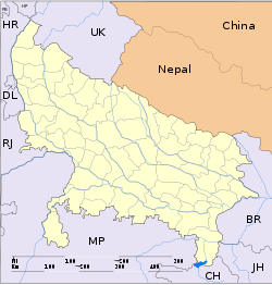
Nakur

Nakur
Nakur
—  city  —
Nakur
Location of Nakur
in Uttar Pradesh and India
Coordinates 29°55′N 77°18′E / 29.92°N 77.3°E / 29.92; 77.3Coordinates: 29°55′N 77°18′E / 29.92°N 77.3°E / 29.92; 77.3
Country India
State Uttar Pradesh
District(s) Saharanpur
Population 20,634 (2001)
Time zone IST (UTC+05:30)
Area

Elevation


261 metres (856 ft)

For the town in Morocco, see Nekor

Nakur is a city and a municipal board in Saharanpur district in the Indian state of Uttar Pradesh.

Geography

Nakur is located at 29°55′N 77°18′E / 29.92°N 77.3°E / 29.92; 77.3.[1] It has an average elevation of 261 metres (856 feet). It is located 24 km from Saharanpur. it is the oldest tahasil. Nakur is formed by Nakul brother of Pandwas

Demographics

As of 2001 India census,[2] Nakur had a population of 20,634. Males constitute 52% of the population and females 48%. Nakur has an average literacy rate of 56%, lower than the national average of 59.5%: male literacy is 64%, and female literacy is 47%. In Nakur, 16% of the population is under 6 years of age. Nakur is Gujjar dominated town.There are several Gujjar villages around Nakur.suryakant rathore (sampla begumpur)

References


Wikimedia Foundation. 2010.

Игры ⚽ Нужна курсовая?

Look at other dictionaries:

  • Nakur — Original name in latin Nakr Name in other language Nakur, Nakr State code IN Continent/City Asia/Kolkata longitude 29.91972 latitude 77.30397 altitude 272 Population 23084 Date 2012 09 06 …   Cities with a population over 1000 database

  • NAKUR — Sur gibi ağızla üflenerek çalınan boruya denir. Nakr; vurmak ve didiklemek mânalarına geldiği gibi, boru çalmak mânasına da gelir. Çünkü boru çalındığı zaman, içinden hava tazyiki ile didiklenmiş olacağı gibi, dışından da o ses, çarptığı… …   Yeni Lügat Türkçe Sözlük

  • Salihiden — Ungefähre Ausdehnung des Salihiden Fürstentums von Nakur (in gelb) Die Salihiden (arabisch ‏صالحيون‎, DMG Ṣāliḥiyūn) waren eine arabische Dynastie, die zwischen dem 8. und 11. Jahrhundert über ein Fürstentum im nor …   Deutsch Wikipedia

  • Saharanpur — Infobox Indian Jurisdiction native name = Saharanpur | type = city | latd = 29.97 | longd = 77.55 locator position = right | state name = Uttar Pradesh district = Saharanpur leader title = leader name = altitude = 269 population as of = 2001… …   Wikipedia

  • Muslim Gujjar (Uttar Pradesh) — Gujjar Total population 342,000 [1] Regions with significant populations •  India • …   Wikipedia

  • Deoband — For the Islamic movement, see Deobandi. Devband   city   …   Wikipedia

  • Timeline of 13th century Muslim history — 13th Century (1201 1300) (597 AH – 700 AH)* 1202: Death of the Ghurid Sultan Ghias ud Din; accession of Mahmud of Ghurid. * 1204: Shahab ud Din Ghuri defeated by the Ghuzz Turks. * 1206: Death of Shahab ud Din Ghuri. Qutb ud Din Aibik crowned… …   Wikipedia

  • Professor Shanku — { bn. প্রোফেসর শঙ্কু, pronounced and spelt as Professor Shonku) is a fictional scientist created by Satyajit Ray in a series of Bangla science fiction books. His full name is Trilokeshwar Shanku, and by occupation, he is an inventor. He is the… …   Wikipedia

  • Chhutmalpur —   city   …   Wikipedia

  • Chilkana Sultanpur —   city   Coordinates Country India State Uttar Pradesh …   Wikipedia

Share the article and excerpts

Direct link
Do a right-click on the link above
and select “Copy Link”