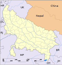
- Mehnagar
-
Mehnagar — city — Coordinates 25°53′N 83°07′E / 25.88°N 83.12°ECoordinates: 25°53′N 83°07′E / 25.88°N 83.12°E Country India State Uttar Pradesh District(s) Azamgarh Population 13,319 (2001[update]) Time zone IST (UTC+05:30) Area
• 61 metres (200 ft)
Mehnagar is a town and a nagar panchayat in Azamgarh district in the Indian state of Uttar Pradesh.
Contents
Geography
Mehnagar is located at 25°53′N 83°07′E / 25.88°N 83.12°E[1]. It has an average elevation of 61 metres (200 feet).
Demographics
As of 2001[update] India census[2], Mehnagar had a population of 13,319. Males constitute 52% of the population and females 48%. Mehnagar has an average literacy rate of 63%, higher than the national average of 59.5%: male literacy is 72%, and female literacy is 53%. In Mehnagar, 18% of the population is under 6 years of age.
History
Mehnagar is a historic place situated 36 km from Azamgarh, in Uttar Pradesh. An ancient fort built by King Haribans and a huge pond is the main draw. An annual religious fair held on the ponds known as Madilaha, 3 km away, is attended by large number of people from far and near. and Azamgarh was founded around 1665, by a powerful landlord named Azam Khan son of Vikramajit. Vikramajit a descendant of Gautam Rajputs of Mehnagar in pargana Nizamabad, like some of his predecessors, had embraced the faith of Islam. A Small Village Katat Chak Katat West Of Madilaha Pond.
References
- ^ Falling Rain Genomics, Inc - Mehnagar
- ^ "Census of India 2001: Data from the 2001 Census, including cities, villages and towns (Provisional)". Census Commission of India. Archived from the original on 2004-06-16. http://web.archive.org/web/20040616075334/http://www.censusindia.net/results/town.php?stad=A&state5=999. Retrieved 2008-11-01.
Categories:- Cities and towns in Azamgarh district
- Uttar Pradesh geography stubs
Wikimedia Foundation. 2010.


