- New York State Route 59
-
NYS Route 59
Korean War Veterans Memorial Highway 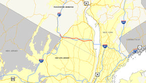
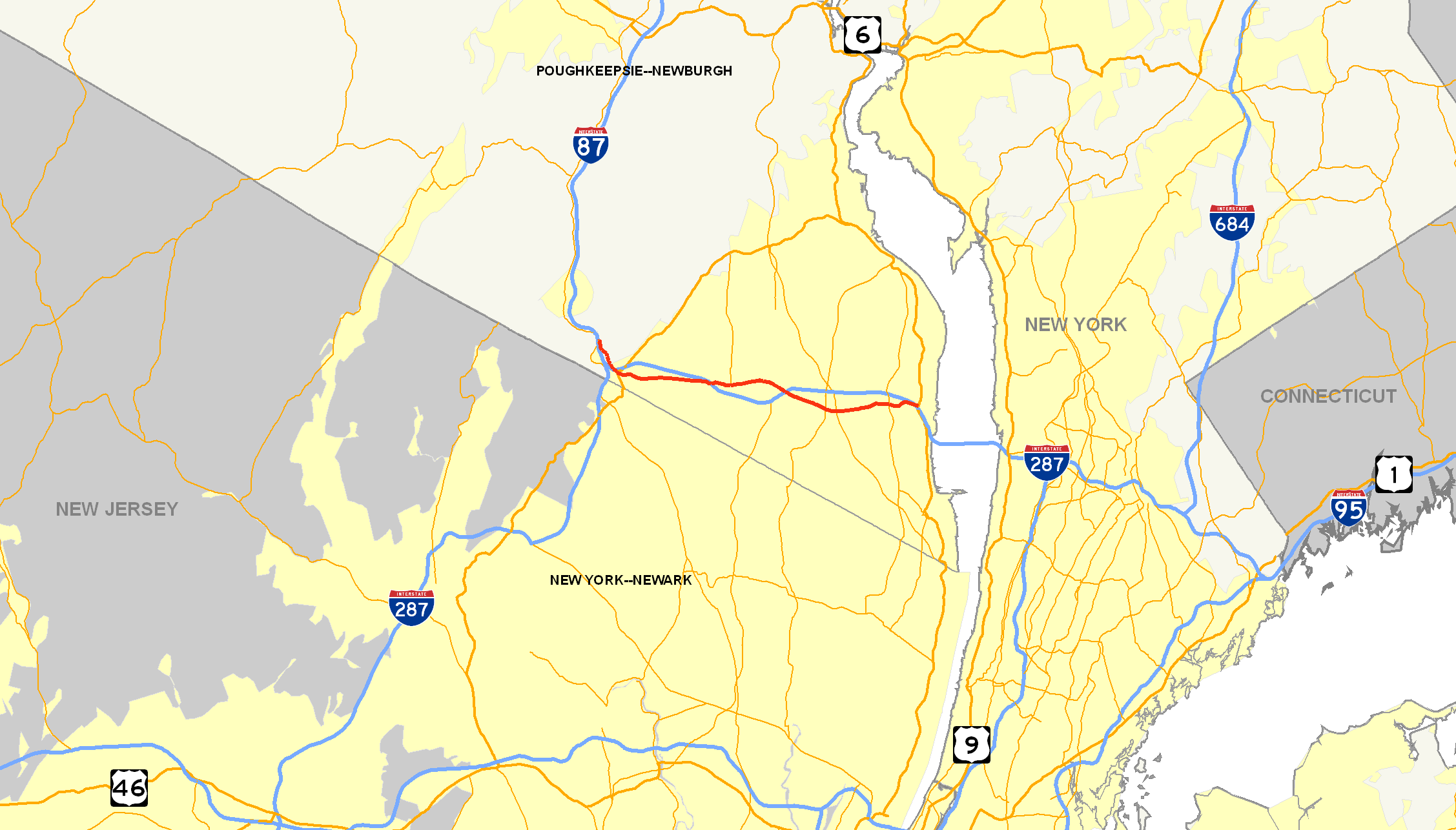
Map of Rockland County with NY 59 highlighted in redRoute information Maintained by NYSDOT Length: 14.08 mi[3] (22.66 km) Existed: late 1920s[1][2] – present Major junctions West end:  NY 17 in Hillburn
 US 202 in Suffern
 NY 306 in Ramapo
 Palisades Parkway in Clarkstown
East end:  US 9W in Nyack
Location Counties: Rockland Highway system Numbered highways in New York
Interstate • U.S. • N.Y. (former) • Reference • County←  NY 58
NY 58NY 60  →
→New York State Route 59 (NY 59) is an east–west state highway in southern Rockland County, New York, in the United States. The route extends for 14.08 miles (22.66 km) from NY 17 in Hillburn to U.S. Route 9W (US 9W) in Nyack. In Suffern, it has a concurrency with US 202 for 0.05 miles (0.08 km). NY 59 runs parallel to the New York State Thruway its entire route. The routing of NY 59 became a state highway in 1911 and was signed as NY 59 in the late 1920s.
When NY 59 was first assigned, it began at NY 17 in Suffern. A western bypass of Suffern was designated as New York State Route 339 ca. 1932; however, it became part of a realigned NY 17 in the mid-1930s. NY 339 was reassigned to NY 17's former routing between Hillburn and Suffern, but it was replaced again ca. 1937 by an extended NY 59. In the 1960s, proposals surfaced for the Spring Valley Bypass, a highway that would utilize the NY 59 corridor between NY 306 in Monsey and NY 45 in Spring Valley. The proposed highway was cancelled as a result of local opposition.
Contents
Route description
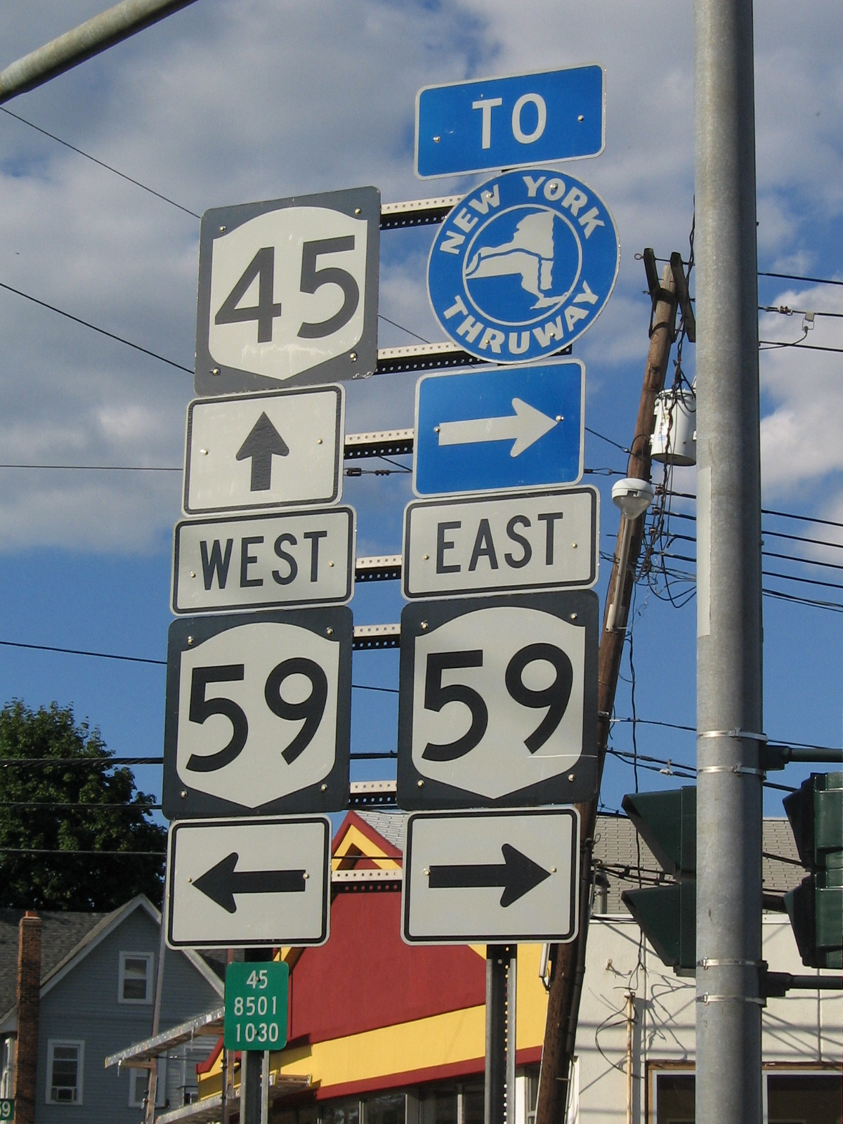
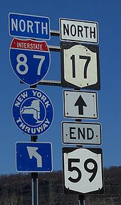 Signs at the intersection between NY 17 and NY 59
NY 59 begins at an intersection with NY 17 in Hillburn, just south of the village of Sloatsburg in southern Rockland County. It heads to the southeast as the Korean War Veterans Memorial Highway, crossing over the Ramapo River and the Norfolk Southern Railway before following both into Suffern. The river leaves NY 59 just inside the village line; however, the railroad continues to run alongside NY 59 into the center of Suffern, where both pass under the New York State Thruway near where Interstate 87 (I-87) connects to I-287.[4]
Just south of the I-87 overpass, NY 59 meets US 202 at Wayne Avenue. US 202 joins NY 59 for a one block wrong way concurrency along Orange Avenue—as NY 59 eastbound is paired with US 202 westbound and vice versa—during which time both routes cross the Norfolk Southern Railway at-grade. At the end of the overlap, US 202 continues south along Orange Avenue to the New Jersey state line while NY 59 forks eastward toward central Rockland County. As NY 59 leaves Suffern and enters Airmont, it passes Good Samaritan Hospital, a major hospital in Rockland County. While in Airmont, NY 59 intersects County Route 89 (CR 89) and CR 85. After leaving Airmont, NY 59 proceeds east through Monsey, where it intersects the southern terminus of NY 306.[4]
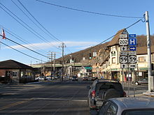 Ahead is NY 59's brief wrong-way concurrency with US 202 in Suffern.
As NY 59 passes Spring Valley High School, it enters the village limits of Spring Valley. While in Spring Valley, NY 59 has an overlap with CR 35A for about a tenth of a mile and meets the Thruway at exit 14. The route continues eastward into Nanuet, where NY 59 passes through a heavy commercialized area. Before its busy intersection with CR 33, NY 59 passes the Nanuet Mall to its south and the Rockland Plaza to its north.[4]
Upon entering West Nyack, NY 59 intersects the Palisades Interstate Parkway (exit 8) and NY 304. The route proceeds onward, passing Palisades Center, one of the largest shopping malls in the country. Immediately after passing the Palisades Center, NY 59 briefly enters Central Nyack. Here it connects to NY 303 by way of an interchange. Before hitting the Nyack town line, NY 59 has its final interchange with the Thruway. The southbound entrance to the Tappan Zee Bridge is via Mountainview Avenue, and the northbound entrance is via Polhemus Street.[4]
At the Nyack line, NY 59 becomes known as Main Street. As Main Street, NY 59 runs under the Thruway one final time before the Thruway heads over the bridge. The route continues toward downtown Nyack; however, it ends at an intersection with US 9W before it reaches the central district. Main Street continues for several blocks into downtown Nyack.[4]
History
Origins
NY 59 originated as the Nyack Turnpike, which was the first major thoroughfare in Rockland County.[5] A petition was filed in 1813 to construct the turnpike. Legislation stemming from the petition was passed on April 17, 1816, allowing construction to begin. The Nyack Turnpike was completed from Suffern to Nyack in the 1830s, despite many years of local opposition to the highway. Its charter was renewed multiple times throughout the 19th century, and it was designated as a toll road to help pay for its upkeep. In 1894, the turnpike was absorbed into the Rockland County road system.[6]
The turnpike was turned over from the county to the state of New York on July 14, 1911,[6] and added to the state highway system as part of Route 39-b, an unsigned legislative route extending from Nyack (at Broadway) to Harriman via modern NY 59 and NY 17.[7] The Route 39-b designation was eliminated on March 1, 1921, as part of a partial renumbering of New York's legislative route system.[8] When the first set of posted routes in New York were assigned in 1924, the portion of former Route 39-b between Suffern and Harriman became part of NY 17. The remainder of the route from Nyack to Suffern was not given a number.[9]
Designation
The Suffern–Nyack highway remained unnumbered until the late 1920s when was designated as NY 59. At the time, NY 59 was routed on West Nyack Road between Nanuet and Central Nyack.[1][2] The route was rendered unchanged in the 1930 renumbering of state highways in New York.[10] Ca. 1932, a western bypass of Suffern was designated as NY 339. The north–south highway left NY 17 at the hamlet of Ramapo and followed the modern New York State Thruway and I-287 corridors south through Hillburn to the New Jersey state line.[11][12] In the mid-1930s, the alignments of NY 17 and NY 339 south of Ramapo were swapped, placing NY 17 on the bypass and NY 339 on the Ramapo–Suffern route. In Suffern, NY 339 ended at a junction with US 202 just one block north of NY 59's western terminus.[13][14] NY 339 was replaced by an extended NY 59 ca. 1937.[15][16]
In the early 1950s, construction began on a bypass of West Nyack Road between Nanuet and West Nyack.[17][18] The highway was completed ca. 1955 and became part of a realigned NY 59. The portion of NY 59's former routing that did not overlap NY 304 was redesignated as NY 59A.[18][19] This designation was short-lived as it was removed from West Nyack Road in the late 1950s.[20][21] In 1960, control of the highway was turned over to the town of Clarkstown, and parts of NY 59A's former routing were abandoned. A local company carried out work to convert the highway into a shopping center access road; however, Rockland County asserted that the town—and by extension the company—had no rights to perform this action. The county sued the company that helped improve the highway in 2002.[22]
Traffic problems
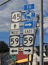 NY 45 at NY 59 in Spring Valley. A mile to the east, NY 59 intersects the Thruway.
During the 1960s, the New York State Department of Transportation (NYSDOT) noticed a population boom in Rockland County. Therefore, a toll-free, limited-access highway was planned to bypass Spring Valley. The Spring Valley Bypass, as it was known, was planned as a "J" shaped road along the east side of existing NY 45 and the south side of NY 59. The southwest end would have been at the intersection of NY 59 and NY 306 in Monsey, while the north end would have been somewhere along NY 45 in New Square. This may have also included a northern extension of the Garden State Parkway. However, it was cancelled due to public opposition.[23]
With the Spring Valley Bypass plan shelved, traffic continued to pour through the Spring Valley – Nanuet area. In 1987, a task force was introduced to come up with a plan to solve this issue. Traffic became even worse when the Nanuet Mall expanded in 1994. NYSDOT tried to fix the worsening situation in 1995 when they reconstructed almost 3 miles (5 km) of NY 59 from the eastern border of Spring Valley to exit 8 of the Palisades Interstate Parkway. The project widened the road to six lanes, helping to move traffic through the area from Grandview to Middletown Roads in Nanuet. In 1997, the New York State Thruway Authority dropped the Spring Valley toll on the Thruway for all motorists except truckers. This helped reduce traffic on NY 59 between exits 14A and 14B.[5]
Shortly after the traffic problems in Nanuet were reduced, the focus was shifted to West Nyack where Palisades Center was being constructed. First proposed in the late 1980s, construction finally started in 1995. This caused major delays for motorists when a bridge was constructed from NY 59 to Palisades Center south parking lot.[24] To keep this portion of NY 59 from being overloaded with mall goers, exit 12 of the Thruway with NY 303 was re-routed through Palisades Center via Palisades Center Drive.[25]
Major intersections
The entire route is in Rockland County.
Location Mile[3] Destinations Notes Hillburn 0.00 
 NY 17 to I-87 / Thruway
Suffern 1.65 US 202 westWestern terminus of US 202 / NY 59 overlap 1.70 US 202 eastEastern terminus of US 202 / NY 59 overlap Ramapo 6.23  NY 306 / CR 73 (East Saddle River Road)
Hamlet of Monsey; southern terminus of NY 306 Spring Valley 7.60  NY 45 (Main Street)
Clarkstown  CR 35A north (New Clarkstown Road)
Western terminus of NY 59 / CR 35A overlap 8.48  I-87 / I-287 / Thruway north / CR 35A south (Forman Drive)
Eastern terminus of NY 59 / CR 35A overlap; exit 14 (I-87 / I-287 / Thruway) I-87 / I-287 / Thruway southExit 14 (I-87 / I-287 / Thruway) 9.50  CR 33 (Middletown Road)
Hamlet of Nanuet West Nyack Road Hamlet of Nanuet; former western terminus of NY 59A 10.29  NY 304
Modified cloverleaf interchange 10.72 Palisades ParkwayExits 8W-E (PIP) West Nyack Road Hamlet of West Nyack; former eastern terminus of NY 59A 12.87  NY 303
Hamlet of Central Nyack; interchange Nyack I-87 / I-287 / Thruway southExit 11 (I-87 / I-287 / Thruway) 14.02 To I-87 / I-287 / Thruway north via Polhemus StreetExit 11 (I-87 / I-287 / Thruway) 14.08 US 9W (Highland Avenue)1.000 mi = 1.609 km; 1.000 km = 0.621 mi References
- ^ a b Standard Oil Company of New York (1927). Road Map of New York in Soconyland (Map). Cartography by General Drafting.
- ^ a b Standard Oil Company of New York (1929). New York in Soconyland (Map). Cartography by General Drafting.
- ^ a b "2008 Traffic Data Report for New York State" (PDF). New York State Department of Transportation. June 16, 2009. p. 201. https://www.nysdot.gov/divisions/engineering/technical-services/hds-respository/NYSDOT_Traffic_Data_Report_2008.pdf. Retrieved December 8, 2009.
- ^ a b c d e Google, Inc. Google Maps – overview map of NY 59 (Map). Cartography by Google, Inc. http://maps.google.com/maps?f=d&hl=en&geocode=2036210090501404969,41.137405,-74.166737%3B16739010844802378770,41.122331,-74.159943%3B4927242213475042011,41.108960,-74.053910%3B8102902720396899452,41.091761,-73.974326%3B14122985737362439143,41.094018,-73.927833&time=&date=&ttype=&saddr=Korean+War+Veterans+Memorial+Hwy%2FRT-17%2FRT-59+%4041.137405,+-74.166737&daddr=Korean+War+Veterans+Memorial+Hwy%2FRT-59+%4041.122331,+-74.159943+to:Korean+War+Veterans+Memorial+Hwy%2FRT-59+%4041.108960,+-74.053910+to:Korean+War+Veterans+Memorial+Hwy%2FRT-59+E+%4041.091761,+-73.974326+to:41.092548,-73.92889&mra=dme&mrcr=0&mrsp=4&sz=14&via=1,2,3&sll=41.10044,-73.940048&sspn=0.028329,0.057764&ie=UTF8&ll=41.100569,-74.070511&spn=0.226633,0.462112&z=11&om=0. Retrieved September 7, 2007.
- ^ a b Rubin, Andrea (October 22, 2002). "Take the main road from the Hudson to Hillburn (and back)". The Journal News (White Plains, New York).
- ^ a b Nannariello, Lynn. "Its About Time". Rockland County Government. http://www.co.rockland.ny.us/Arts/Turnpike.html. Retrieved February 28, 2008.
- ^ State of New York Commission of Highways (1919). The Highway Law. Albany, New York: J. B. Lyon Company. p. 68. http://books.google.com/books?id=hZ4AAAAAMAAJ&pg=PA68. Retrieved December 16, 2009.
- ^ New York State Legislature (1921). "Tables of Laws and Codes Amended or Repealed". Laws of the State of New York passed at the One Hundred and Forty-Fourth Session of the Legislature. Albany, New York: J. B. Lyon Company. pp. 42, 69–70. http://books.google.com/books?id=6pE4AAAAIAAJ&pg=PA42. Retrieved April 17, 2010.
- ^ "New York's Main Highways Designated by Numbers". The New York Times: p. XX9. December 21, 1924.
- ^ Dickinson, Leon A. (January 12, 1930). "New Signs for State Highways". The New York Times: p. 136.
- ^ Kendall Refining Company (1931). New York (Map). Cartography by H.M. Gousha Company.
- ^ Texas Oil Company (1932). Texaco Road Map – New York (Map). Cartography by Rand McNally and Company.
- ^ Texas Oil Company (1934). Texaco Road Map – New York (Map). Cartography by Rand McNally and Company.
- ^ Shell Oil Company (1936). Road Map – Metropolitan New York and Long Island (Map). Cartography by H.M. Gousha Company.
- ^ Shell Oil Company (1936). Road Map – New York (Map). Cartography by H.M. Gousha Company.
- ^ Shell Oil Company (1937). Shell Road Map – New York (Map). Cartography by H.M. Gousha Company.
- ^ Sunoco (1952). New York (Map). Cartography by Rand McNally and Company.
- ^ a b Esso (1954). New York with Special Maps of Putnam–Rockland–Westchester Counties and Finger Lakes Region (Map). Cartography by General Drafting (1955–56 ed.).
- ^ United States Geological Survey (1955). Park Ridge Quadrangle – New Jersey – New York (Map). 1:24,000. 7.5 Minute Series (Topographic). http://www.nysgis.state.ny.us/gisdata/quads/drg24/usgspreview/index.cfm?code=o41074a1. Retrieved December 5, 2009.
- ^ Gulf Oil Company (1958). New York and New Jersey Tourgide Map (Map). Cartography by Rand McNally and Company. Northeastern New Jersey inset.
- ^ Gulf Oil Company (1960). New York and New Jersey Tourgide Map (Map). Cartography by Rand McNally and Company. Northeastern New Jersey inset.
- ^ County of Rockland vs. Ecklecco (New York Courts Appellate Division 2003).
- ^ Anderson, Steve. "Spring Valley Bypass History". NYCRoads. http://www.nycroads.com/roads/NY-45/. Retrieved February 17, 2008.
- ^ Feron, James (December 31, 1988). "Plan to Build Huge Mall Under Attack in Rockland". The New York Times. http://query.nytimes.com/gst/fullpage.html?res=940DEFDD1630F932A05751C1A96E948260&sec=&spon=&pagewanted=2. Retrieved December 16, 2009.
- ^ Perry, N.W.. "Exit 12 Re-routed with Construction of Palisades Center". Empire State Roads. http://www.empirestateroads.com/week/week31.html. Retrieved February 26, 2008.
External links
Categories:- State highways in New York
- Transportation in Rockland County, New York


Wikimedia Foundation. 2010.