- New York State Route 45
-
"NY 45" redirects here. NY 45 may also refer to New York's 45th congressional district.This article is about the current alignment of NY 45. For previous alignments of NY 45, see New York State Route 45 (disambiguation).
NYS Route 45
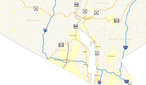
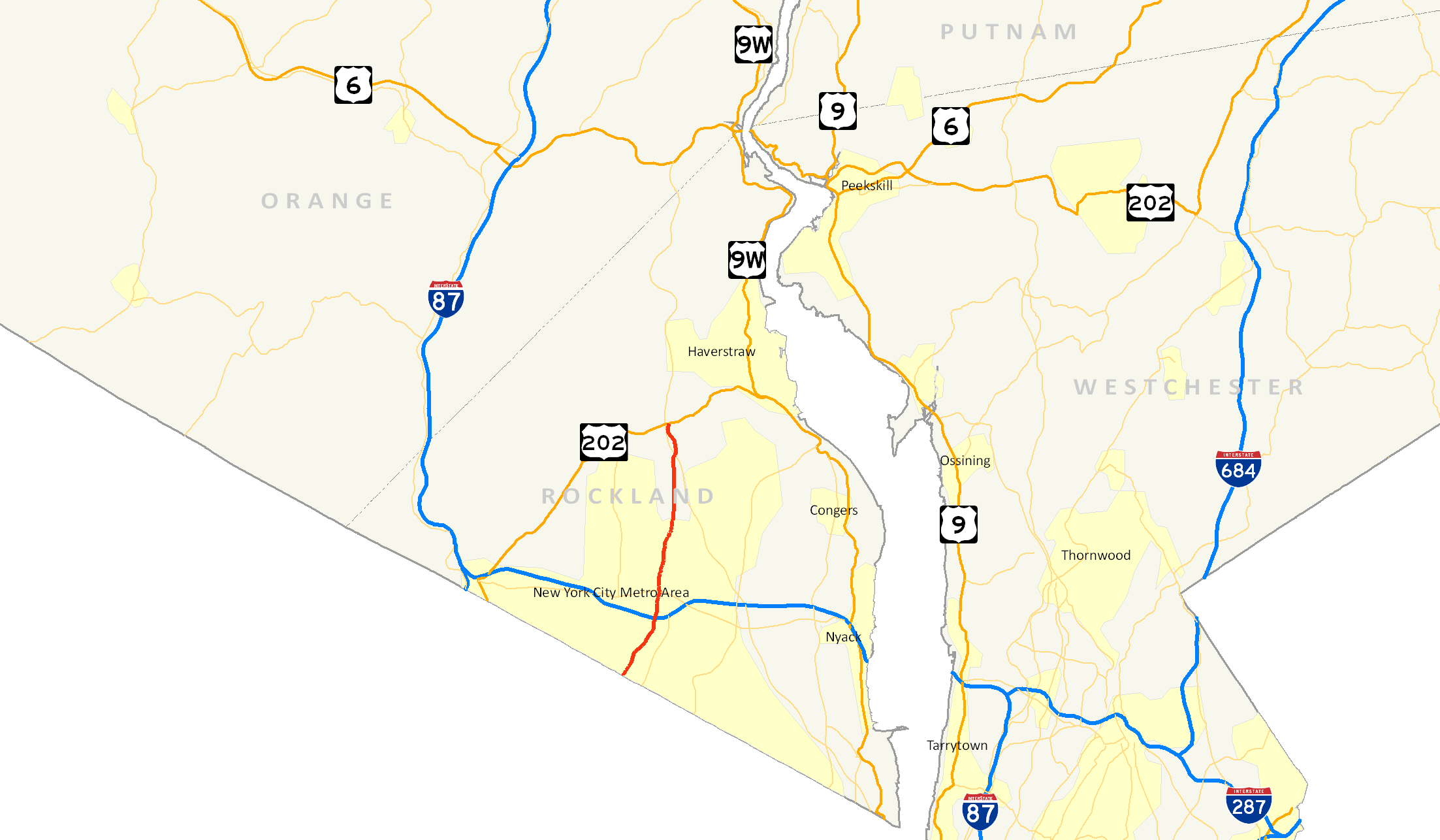
Map of the Lower Hudson Valley with NY 45 highlighted in redRoute information Maintained by NYSDOT Length: 8.60 mi[3] (13.84 km) Existed: late 1940s[1][2] – present Major junctions South end:  CR 73 at Chestnut Ridge
 NY 59 in Spring Valley
 Palisades Parkway in Pomona
North end:  US 202 in Haverstraw
Location Counties: Rockland Highway system Numbered highways in New York
Interstate • U.S. • N.Y. (former) • Reference • County←  US 44
US 44NY 46  →
→New York State Route 45 (NY 45) is a north–south state highway in central Rockland County, New York, United States. It spans 8.60 miles (13.84 km) from the village of Chestnut Ridge at the New Jersey – New York border, where it becomes County Route 73 (CR 73) in Bergen County, New Jersey, to U.S. Route 202 (US 202) in the town of Haverstraw. Though an interchange does exist between NY 45 and the Palisades Interstate Parkway, the route has no access to the New York State Thruway.
NY 45 was originally designated as New York State Route 305 as part of the 1930 renumbering of state highways in New York. It was renumbered to New York State Route 94 in the early 1940s before becoming NY 45 in the late 1940s.
Contents
Route description
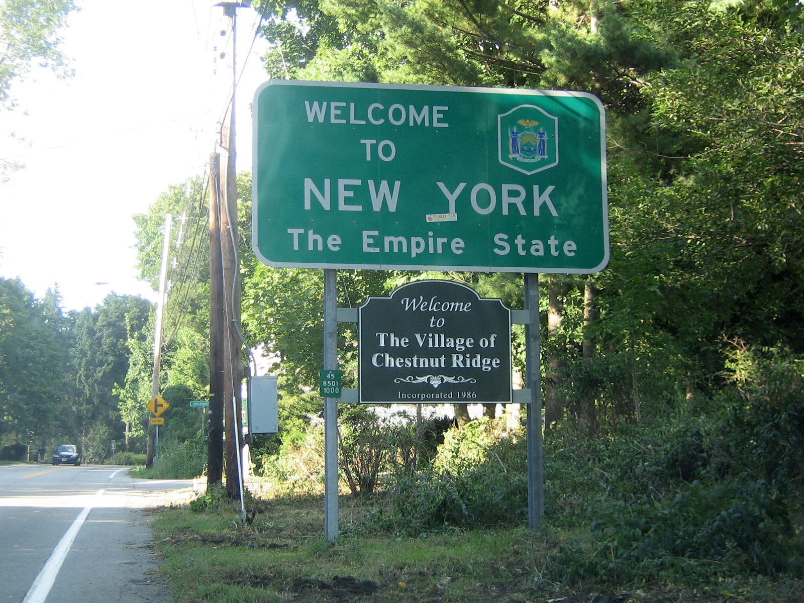
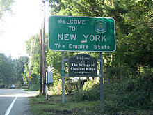 NY 45 begins here at the New York – New Jersey state line in Chestnut Ridge.
NY 45 begins at the New Jersey – New York border in Chestnut Ridge. Although the first NY 45 reassurance shield doesn't appear for a quarter-mile, the reference marker below the "Welcome to New York" sign at the crossing indicates the beginning of NY 45.[4]
NY 45 runs parallel to the small portion of the Garden State Parkway (GSP) that enters New York. Officially this portion is considered an extension of the New York State Thruway. While NY 45 never intersects the GSP, it provides a link to the parkway. South of the New Jersey border in Bergen County, CR 73 intersects the GSP, and in New York, NY 45 intersects CR 41, which intersects the parkway. Through Chestnut Ridge (where it is known as Chestnut Ridge Road, just as CR 73, its southern extension, is in New Jersey), it crosses the New York State Thruway.[4]
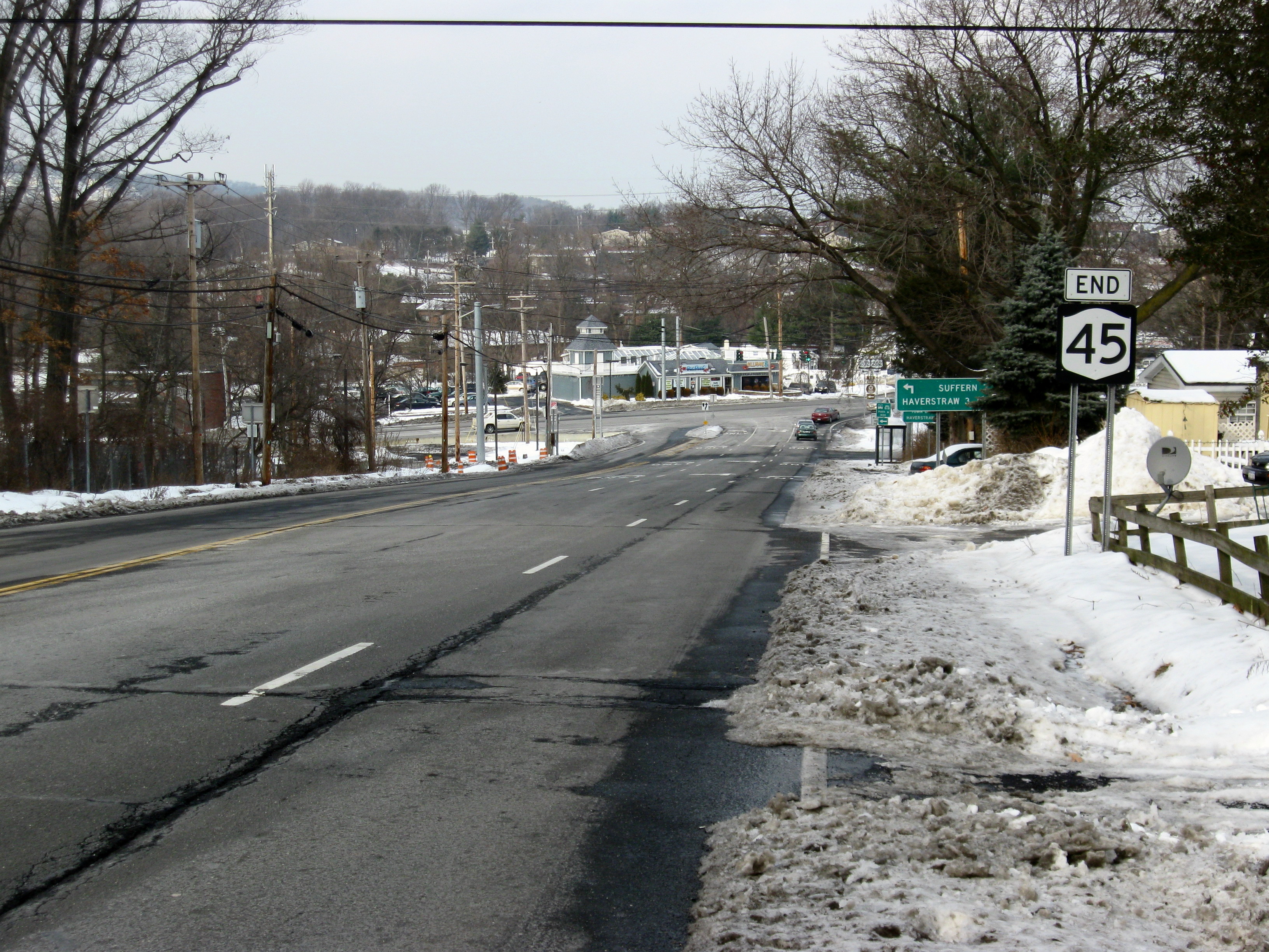
 NY 45's northern terminus at US 202 in Mount Ivy near exit 13 of the Palisades Parkway.
Once it enters Spring Valley (where it is known locally first as South Main Street, then as North Main Street after it crosses its very busy intersection with NY 59), NY 45 continues northward through the downtown business district. Traffic here tends to pile up many times a day. After NY 45's intersection at Hillcrest with CR 74 (the location of several small shopping centers), traffic tends to ease up. North of there, NY 45 provides a link to the Hassidic Jewish community of New Square, although it never enters the village limits. At CR 80, NY 45 enters New Hempstead. Again the road becomes relatively quiet, but it begins to parallel the Palisades Interstate Parkway, until its intersection at exit 12 in Pomona. NY 45 quickly leaves Pomona and enters Mount Ivy. This is where NY 45 comes to its northern terminus at US 202. This area of US 202 is in downtown Mount Ivy, and exit 13 of the Palisades is just 0.1 miles (0.2 km) west of NY 45's northern terminus.[4]
History
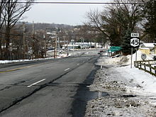
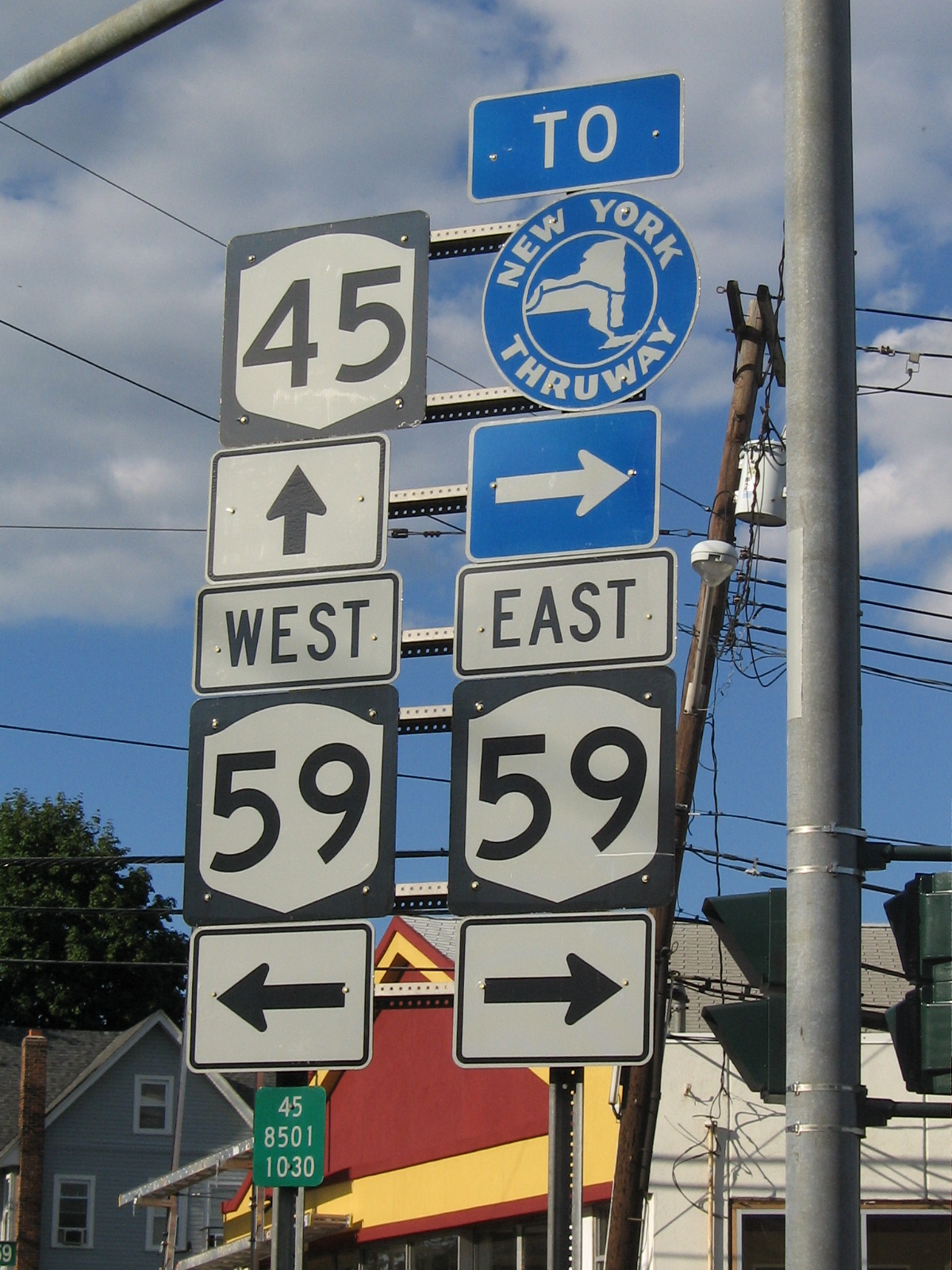
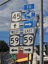 NY 45 at NY 59 in Spring Valley. NY 59 intersects the Thruway 1 mile (1.6 km) to the east.
What is now NY 45 was originally designated NY 305 as part of the 1930 renumbering of state highways in New York.[5] At the same time, the portion of modern NY 305 north of Portville in Cattaraugus and Allegany Counties was assigned NY 94, while the current NY 94 in Orange County was designated NY 45.[6] The NY 305 and NY 94 designations were swapped in the early 1940s, placing NY 305 on its current alignment and NY 94 on what is now NY 45.[7][8] NY 94 was then swapped again, this time for NY 45, in the late 1940s, placing both routes on their modern routings.[1][2]
A toll-free, limited-access highway was once planned to bypass Spring Valley. This was planned as a "J" shaped road along the east side of the existing NY 45 and the south side of NY 59. The southwest end would have been at the intersection of NY 59 and NY 306 in Monsey, while the north end would have been somewhere along NY 45 in New Square. This may have also included a northern extension of the Garden State Parkway. However, it was cancelled due to public opposition.[9]
Major intersections
The entire route is in Rockland County.
Location Mile[3] Destinations Notes Chestnut Ridge 0.00 CR 73Continuation into New Jersey Spring Valley 2.48  CR 52 (Old Nyack Turnpike)
3.02 NY 59To I-87 / I-287 / Thruway 4.35  CR 74 (Eckerson Road)
New Hempstead 5.94  CR 80 (New Hempstead Road)
Pomona 7.51 Palisades ParkwayExit 12 (Palisades Parkway) Town of Haverstraw 8.60 US 202 (Ramapo Road)Hamlet of Mount Ivy 1.000 mi = 1.609 km; 1.000 km = 0.621 mi References
- ^ a b State of New York Department of Public Works. Official Highway Map of New York State (Map). Cartography by General Drafting (1947–48 ed.).
- ^ a b Socony-Vacuum Oil Company (1950). New York (Map). Cartography by Rand McNally and Company.
- ^ a b "2008 Traffic Data Report for New York State" (PDF). New York State Department of Transportation. June 16, 2009. p. 192. https://www.nysdot.gov/divisions/engineering/technical-services/hds-respository/NYSDOT_Traffic_Data_Report_2008.pdf. Retrieved November 14, 2009.
- ^ a b c Google, Inc. Google Maps – overview map of NY 45 (Map). Cartography by Google, Inc. http://maps.google.com/maps?f=d&hl=en&geocode=13984407418814486780,41.071100,-74.067897%3B10484653242226915817,41.186488,-74.036055&time=&date=&ttype=&saddr=41.071093,-74.067898&daddr=RT-45+%4041.186488,+-74.036055&mra=dme&mrcr=0&mrsp=0&sz=18&sll=41.071478,-74.066391&sspn=0.001763,0.003648&ie=UTF8&ll=41.144018,-74.076691&spn=0.225449,0.466919&z=11&om=1. Retrieved September 8, 2007.
- ^ Automobile Legal Association (ALA) Automobile Green Book, 1930/31 and 1931/32 editions, (Scarborough Motor Guide Co., Boston, 1930 and 1931). The 1930/31 edition shows New York state routes prior to the 1930 renumbering
- ^ Standard Oil Company of New York (1930). Road Map of New York (Map). Cartography by General Drafting.
- ^ Gulf Oil Company (1940). New York Info-Map (Map). Cartography by Rand McNally and Company.
- ^ Esso (1942). New York with Pictorial Guide (Map). Cartography by General Drafting.
- ^ Anderson, Steve. "Spring Valley Bypass History". NYCRoads. http://www.nycroads.com/roads/NY-45/. Retrieved February 17, 2008.
External links
Categories:- State highways in New York
- Transportation in Rockland County, New York

Wikimedia Foundation. 2010.