- New York State Route 306
-
NYS Route 306
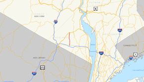
Map of the Lower Hudson Valley with NY 306 highlighted in redRoute information Maintained by NYSDOT Length: 5.33 mi[2] (8.58 km) Existed: 1930[1] – present Major junctions South end: 
 NY 59 / CR 73 in Ramapo
North end:  US 202 in Pomona
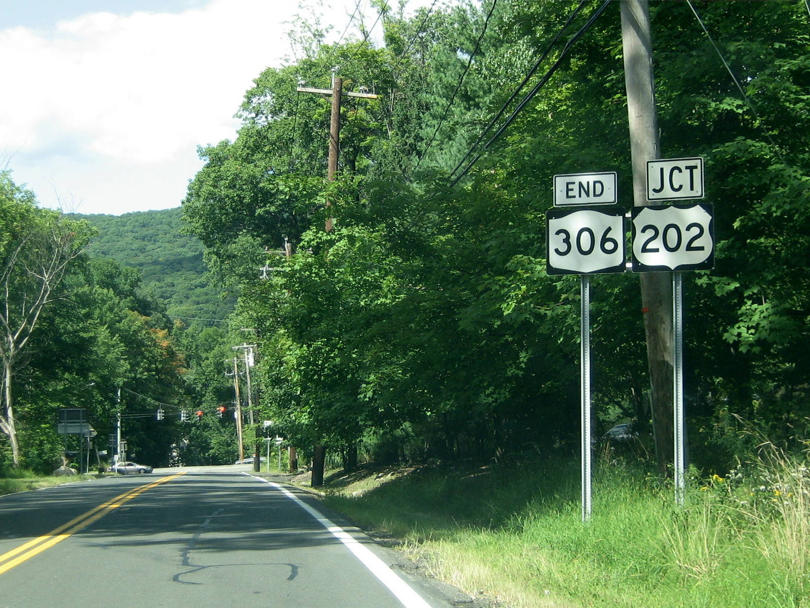
Location Counties: Rockland Highway system Numbered highways in New York
Interstate • U.S. • N.Y. (former) • Reference • County←  NY 305
NY 308  →
→New York State Route 306 (NY 306) is a north–south state highway in western Rockland County, New York in the United States. NY 306 runs from NY 59 in the hamlet of Monsey to U.S. Route 202 (US 202) in Ladentown, on the western boundary of the village of Pomona. The road is currently 5.33 miles (8.58 km) long; however, it originally extended south to the New Jersey state line and north to Willow Grove Road (former NY 210) when it was assigned as part of the 1930 renumbering of state highways in New York.
Contents
Route description
 The northern terminus of NY 306 at US 202 in Pomona.
NY 306 begins at NY 59 in the Ramapo hamlet of Monsey and proceeds north as Main Street through part of the business district of Monsey. After passing Maple Avenue in the Jewish village of Kaser, NY 306 becomes Monsey-Ladentown Road for the rest of its run. NY 306 quickly leaves the small village and reenters the town of Ramapo.[3]
Roughly 1 mile (1.6 km) north of Kaser, NY 306 intersects County Route 74 (CR 74). Ramapo High School is located just east of NY 306 on CR 74. NY 306 then passes a fairly large cemetery called Church of the West Hempstead Cemetery. NY 306 continues north past CR 80, and enters the village of Wesley Hills. There it passes a small shopping center, and proceeds into residential areas. Finally, NY 306 enters Pomona at CR 86. The route ends shortly afterward at US 202.[3]
History
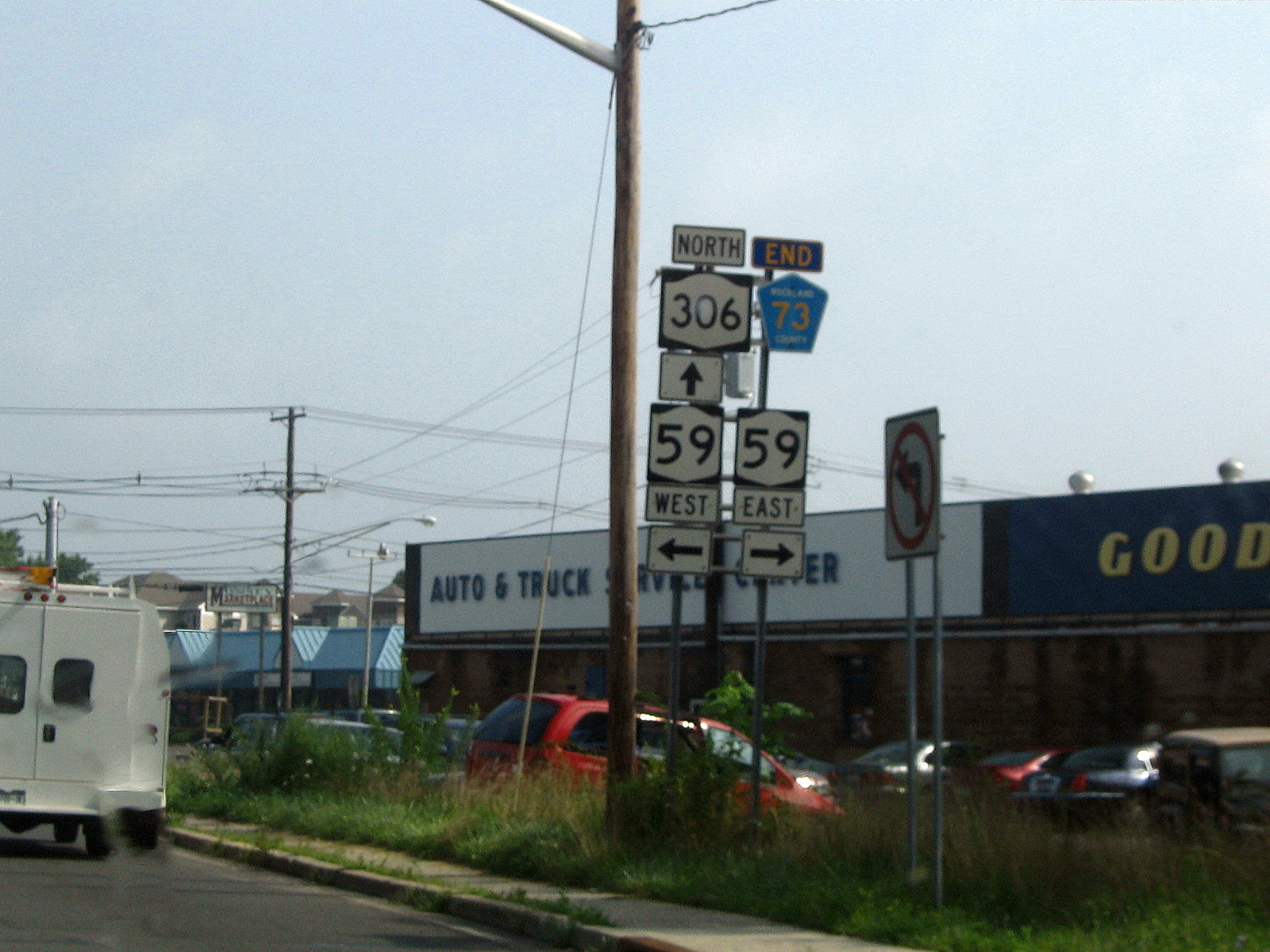
 NY 306 begins here at NY 59. It used to begin at the New Jersey state line and encompass all of current CR 73.
When NY 306 was assigned as part of the 1930 renumbering of state highways in New York,[1] it extended from the New Jersey state line in the south to Willow Grove Road (then part of NY 210) in the north via East Saddle River Road, Monsey-Ladentown Road, and Call Hollow Road.[4] NY 306 was truncated to its current northern terminus at US 202 in Ramapo (now part of the village of Pomona) ca. 1939[4][5] and to its modern southern end at NY 59 in Monsey ca. 1962.[6][7] The former extensions of NY 306 are now largely maintained by Rockland County as CR 73 (East Saddle River Road) and CR 75 (Call Hollow Road north of the Ramapo town line).[8][9] The current southern terminus of NY 306 in Monsey was the proposed southwestern terminus of the Spring Valley Bypass, a bypass of NY 45 and NY 59 that was never built.[10][11]
Major intersections
The entire route is in Rockland County.
Location Mile[2] Destinations Notes Ramapo 0.00 NY 59 / CR 73 (East Saddle River Road)Hamlet of Monsey Kaser 0.63  To CR 64 via Maple Avenue
Wesley Hills 2.89  CR 80 (Grandview Avenue)
5.33 US 2021.000 mi = 1.609 km; 1.000 km = 0.621 mi References
- ^ a b Standard Oil Company of New York (1930). Road Map of New York (Map). Cartography by General Drafting.
- ^ a b "2008 Traffic Data Report for New York State" (PDF). New York State Department of Transportation. June 16, 2009. p. 291. https://www.nysdot.gov/divisions/engineering/technical-services/hds-respository/NYSDOT_Traffic_Data_Report_2008.pdf. Retrieved December 9, 2009.
- ^ a b Google, Inc. Google Maps – overview map of NY 306 (Map). Cartography by Google, Inc. http://maps.google.com/maps?f=d&hl=en&geocode=11908941531828256426,41.107357,-74.069614%3B14131535258017380517,41.182732,-74.067798&time=&date=&ttype=&saddr=Main+St+%4041.107357,+-74.069614&daddr=41.18275,-74.067818&mra=dme&mrcr=0&mrsp=1&sz=19&sll=41.182621,-74.068043&sspn=0.00088,0.001824&ie=UTF8&ll=41.144277,-74.066734&spn=0.225447,0.466919&z=11&om=1. Retrieved September 8, 2007.
- ^ a b United States Geological Survey (1938). New York-New Jersey – Ramapo Quadrangle (northeastern portion) (Map). 1:62,500. http://docs.unh.edu/NY/ramp38ne.jpg. Retrieved December 31, 2009.
- ^ Standard Oil Company (1939). New York (Map). Cartography by General Drafting.
- ^ Sunoco (1961). New York and Metropolitan New York (Map). Cartography by H.M. Gousha Company (1961–62 ed.).
- ^ Esso (1962). New York with Sight-Seeing Guide (Map). Cartography by General Drafting.
- ^ New York State Department of Transportation (1990). Park Ridge Digital Raster Quadrangle (Map). 1:24,000. http://www.nysgis.state.ny.us/gisdata/quads/drg24/dotpreview/index.cfm?code=ff46. Retrieved December 31, 2009.
- ^ New York State Department of Transportation (1990). Thiells Digital Raster Quadrangle (Map). 1:24,000. http://www.nysgis.state.ny.us/gisdata/quads/drg24/dotpreview/index.cfm?code=ee46. Retrieved December 31, 2009.
- ^ Anderson, Steve. "Spring Valley Bypass (NY 45 and NY 59, unbuilt)". NYCRoads. http://www.nycroads.com/roads/NY-45/. Retrieved December 31, 2009.
- ^ American Automobile Association (1968). New York City and Vicinity, Including Long Island (Map).
External links
Categories:- State highways in New York
- Transportation in Rockland County, New York


Wikimedia Foundation. 2010.