- New York State Route 305
-
This article is about the current alignment of NY 305. For the former alignment of NY 305 in Rockland County, see New York State Route 305 (1930 – early 1940s).
NYS Route 305 Route information Maintained by NYSDOT Length: 31.35 mi[4] (50.45 km) History: Designated NY 94 in 1930;[1] renumbered to NY 305 in early 1940s[2][3] Major junctions South end:  PA 446 at Portville
 I-86 / NY 17 in Cuba
North end:  NY 19 in Belfast
Location Counties: Cattaraugus, Allegany Highway system Numbered highways in New York
Interstate • U.S. • N.Y. (former) • Reference • County←  NY 304
NY 306  →
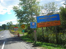
→New York State Route 305 (NY 305) is a north–south route in the Southern Tier that runs from the Pennsylvania state line in Cattaraugus County to the hamlet of Belfast in Allegany County, where it ends at NY 19. It intersects the Southern Tier Expressway (Interstate 86/NY 17) in Cuba.
Contents
History
The segment of modern NY 305 north of Cuba was originally the southernmost portion of Route 16, an unsigned legislative route assigned by the New York State Legislature in 1908. At Belfast, Route 16 continued north on what is now NY 19.[5][6] The Cuba–Belfast section of legislative Route 16 was assigned a posted route designation as part of the 1930 renumbering of state highways in New York when it was designated as the northern half of NY 94, which continued south through Cuba to NY 17 (now NY 417) in Portville. At the same time, what is now NY 45 in Rockland County was designated as NY 305.[1][7] The NY 94 and NY 305 designations were swapped in the early 1940s, placing NY 305 on its current alignment from Portville to Belfast.[2][3] South of Portville, what is now NY 305 was originally designated as part of NY 16 ca. 1931.[1][8] It was added to NY 305 ca. 1963 when NY 16 was rerouted south of Olean to follow what had been NY 16A.[9][10]
Major intersections
County Location Mile[4] Destinations Notes Cattaraugus Town of Portville 0.00  PA 446
Continuation into Pennsylvania 1.89  NY 417 east
Southern terminus of NY 305 / NY 417 overlap Village of Portville 2.67  NY 417 west
Northern terminus of NY 305 / NY 417 overlap Allegany Village of Cuba 18.33  NY 446
Eastern terminus of NY 446 18.67 
 I-86 / NY 17
Exit 28 (I-86 / NY 17) Belfast 31.35  NY 19
NY 191.000 mi = 1.609 km; 1.000 km = 0.621 mi References
- ^ a b c Standard Oil Company of New York (1930). Road Map of New York (Map). Cartography by General Drafting.
- ^ a b Gulf Oil Company (1940). New York Info-Map (Map). Cartography by Rand McNally and Company.
- ^ a b Esso (1942). New York with Pictorial Guide (Map). Cartography by General Drafting.
- ^ a b "2008 Traffic Volume Report for New York State" (PDF). New York State Department of Transportation. June 16, 2009. pp. 210–211. https://www.nysdot.gov/divisions/engineering/technical-services/hds-respository/NYSDOT%20TVR%202008%20by%20Route.pdf. Retrieved February 1, 2010.
- ^ State of New York Department of Highways (1909). The Highway Law. Albany, New York: J. B. Lyon Company. pp. 59–60. http://books.google.com/books?id=jZ0AAAAAMAAJ&pg=PA59. Retrieved June 10, 2010.
- ^ New York State Department of Highways (1920). Report of the State Commissioner of Highways. Albany, New York: J. B. Lyon Company. pp. 524–525. http://books.google.com/books?id=Sj4CAAAAYAAJ&pg=PA524. Retrieved June 10, 2010.
- ^ Standard Oil Company of New York (1929). New York in Soconyland (Map). Cartography by General Drafting.
- ^ Standard Oil Company (1931). New York (Map). Cartography by General Drafting.
- ^ Esso (1962). New York with Sight-Seeing Guide (Map). Cartography by General Drafting.
- ^ Esso (1963). New York Happy Motoring Guide (Map). Cartography by General Drafting (1963 ed.).
External links
Categories:- State highways in New York
- Transportation in Allegany County, New York
- Transportation in Cattaraugus County, New York
Wikimedia Foundation. 2010.


