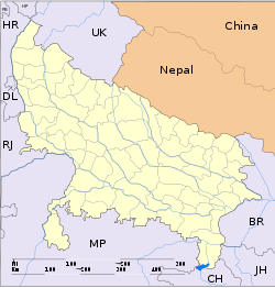
- Dankaur
-
Dankaur — city — Coordinates 28°21′N 77°33′E / 28.35°N 77.55°ECoordinates: 28°21′N 77°33′E / 28.35°N 77.55°E Country India State Uttar Pradesh District(s) Gautam Buddha Nagar Population 11,982 (2001[update]) Time zone IST (UTC+05:30) Area
• 194 metres (636 ft)
Dankaur is a town and a nagar panchayat in Gautam Buddha Nagar District in the state of Uttar Pradesh, India.
Contents
Geography
Dankaur is located at 28°21′N 77°33′E / 28.35°N 77.55°E.[1] It has an average elevation of 194 metres (636 feet). It is situated approximately 55 kilometres east of Delhi along the bank of river Yamuna.The place is well connected by rail link on Northern Railway on Delhi-Aligarh link.
Demographics
As of 2001[update] India census,[2] Dankaur had a population of 11,982. Males constitute 54% of the population and females 46%. Dankaur has an average literacy rate of 57%, lower than the national average of 59.5%: male literacy is 67% and, female literacy is 47%. In Dankaur, 16% of the population is under 6 years of age.
There is a proposal to make an International Airport in Dankaur in support of Greater Noida Export processing Zone. The TAJ EXPRESSWAY Project is also going on which is a 8 lane expressway joining Delhi/Noida to Agra.
The international airport is being established at Jewar and not at Dankaur and the Indian Govt has already accorded the approval in principle for this project, which will send the whole area in a mode of fast track development.
History
Dankaur is also known for historic reasons. Mythologically its name is supposed to be on the name of Guru Dronacharya.It was known as DRONKAUR in ancient times.It is believed that in ancient times of MAHABHARAT era, guru DRONACHARYA(Drona) who used to teach art of archery to Pandavas and Kauravas refused to teach a Bheel(fisherman) called Eklavya. Eklavya in turn cast a stone into his guru and started practising on his own.That stone is still present in ancient Dronacharya temple in the town.
Most of Dankaur was owned by a very wealthy Nawab, Nawab Shaukat Ali. The Nawab's house and orchards were brought from him by Lt Col Tejveer Singh son of a prominent Indian judge during the British Raj. The house stood within the Nawab's mango orchards and has a heart shaped garden. The Nawab used to solve disputes brought to him by the villagers in his kacheri(local court) here. After independence Nawab Shaukat Ali sold his land to the army officer and left for Pakistan with his second wife.
Near Dankaur in the village Bilaspur the British established a base and from here they collected taxes from over 1900 villages. The remains of the British fortress and the cavalry association graveyard still exist.
see also
- dankaur greater noida
- mirzapur niloni
- Rampur Bangar
- rabupura
References
- ^ Falling Rain Genomics, Inc - Dankaur
- ^ "Census of India 2001: Data from the 2001 Census, including cities, villages and towns (Provisional)". Census Commission of India. Archived from the original on 2004-06-16. http://web.archive.org/web/20040616075334/http://www.censusindia.net/results/town.php?stad=A&state5=999. Retrieved 2008-11-01.
Categories:- Cities and towns in Gautam Buddha Nagar district
- Uttar Pradesh geography stubs
Wikimedia Foundation. 2010.


