- Malay Archipelago
-
This article is about the large island group. For the book, see The Malay Archipelago.
Malay Archipelago 
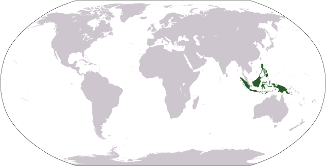
World map highlighting Malay Archipelago. New Guinea—not part of the Malay Archipelago by some definitions—is also included.Geography Location Southeast Asia, Oceania Total islands 25,000 - 30,000 Major islands Borneo, Java, Luzon, Mindanao, New Guinea, Sulawesi, Sumatra Area 2,000,000 km2 (800,000 sq mi) Highest point
[1]Country Demographics Population 350 million.[2] Ethnic groups Austronesian peoples, Malay, Overseas Chinese The Malay Archipelago refers to the archipelago between mainland Southeastern Asia and Australia. The name was derived from the anachronistic concept of a Malay race.[3]
It has also been called the Indo-Australian Archipelago, East Indies, Indonesian Archipelago, and other names over time. The term is largely synonymous with the term Maritime Southeast Asia. Situated between the Indian and Pacific Oceans, the group of over 25,000 islands is the largest archipelago by area, and fourth by number of islands in the world. It includes Indonesia, the Philippines, Singapore, Brunei, East Malaysia and East Timor.[4] The island of New Guinea or islands of Papua New Guinea are not always included in definitions of the Malay Archipelago.[4][5]
Contents
Etymology and terminology
The term was derived from the concept of a Malay race,[3] which included the peoples of the modern-day nations of Indonesia (excluding western New Guinea), Malaysia, Brunei, East Timor and the Philippines. The racial concept was proposed by European explorers based on their observations of the influence of the ethnic Malay empire (Indonesia), Srivijaya.[6]
The 19th century naturalist Alfred Wallace used the term "Malay Archipelago" as the title of his influential book documenting his studies in the region. Wallace also referred to the area as the "Indian Archipelago" and the "Indo-Australian" Archipelago.[7] He included within the region the Solomon Islands and the Malay Peninsula due to physiographic similarities.[7] As Wallace noted,[8] there are arguments for excluding Papua New Guinea for cultural and geographical reasons: Papua New Guinea is culturally quite different from the other countries in the region, and the island of New Guinea itself is geologically not part of the continent of Asia, as the islands of the Sunda Shelf are (see Australia).
The archipelago was called the "East Indies"[9] in the European colonial era and is still sometimes referred to as such,[4] but broader usages of the "East Indies" term had included Indochina and the Indian subcontinent. Indonesians use the term "Nusantara" for the "Malay archipelago".[10] The area is also referred to as the Indonesian archipelago.[11][12]
Geography
The land and sea area of the archipelago exceeds 2 million km2.[1] The over 25,000 islands of the archipelago comprise many smaller archipelagoes.[13]
The major groupings are:
- Indonesia
- Philippine Archipelago
The six largest islands are New Guinea, Borneo, Sumatra, Sulawesi, Java, and Luzon.
Geologically the archipelago is one of the most active volcanic regions in the world. Tectonic uplifts have produced large mountains, including the highest in Mount Kinabalu in Sabah with a height of 4,095.2 m and Puncak Jaya in Papua at 4,884 m (16,024 ft). The climate throughout the archipelago, owing to its position on the equator, is tropical.
Size
Malay Archipelago (or Indonesian Archipelago) is often referred to as the largest archipelago in the world, but this is meant by area and not by number of islands. This title aptly represents its 25,000 - 30,000 or so islands which span 5,400 kilometres (3,400 mi) eastward from Sabang in northern Sumatra to Merauke in Irian Jaya. If you superimpose a map of Indonesia over one of Eurasia, you will find that it stretches from Eastern France to Western China; compared to the United States, it covers the area from Eastern California to Bermuda.
Biogeography
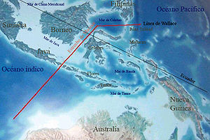 Wallace's line between Australian and Southeast Asian fauna. The deep water of the Lombok Strait between the islands of Bali and Lombok formed a water barrier even when lower sea levels linked the now-separated islands and landmasses on either side.
Wallace used the term “Malay Archipelago” as the title of his influential book documenting his studies in the region. He proposed the "Wallace Line", a boundary that separated the flora and fauna of Asia and Australia. The ice age boundary was formed by the deep water straits between Borneo and Sulawesi; and through the Lombok Strait between Bali and Lombok. This is now considered the western border of the Wallacea transition zone between the zoogeographical regions of Asia and Australia. The zone has a mixture of species of Asian and Australian origin, and its own endemic species.
Demography
Over 350 million people live in the region, with the most populated island being Java. The people living there are predominantly from Austronesian subgroupings and correspondingly speak western Malayo-Polynesian languages. This region of Southeast Asia shares more social and cultural ties with other Austronesian peoples in the Pacific than with the peoples of Mainland Southeast Asia. The main religions in this region are Islam, Christianity, Buddhism, Hinduism and traditional Animism.
Culturally, the region is often seen[who?] as part of 'Farther India' or Greater India -- the Coedes 'Indianized states of Southeast Asia' refers to it as 'Island Southeast Asia'.[14]
See also
- Indonesian Archipelago (disambiguation)
- Insulindia
- Malay Peninsula
- Malesia
- Nanyang (geographic region)
Notes
- ^ a b Moores, Eldridge M.; Fairbridge, Rhodes Whitmore (1997). Encyclopedia of European and Asian regional geology. Springer. p. 377. ISBN 0412740400. http://books.google.com/?id=aYRup5mRcGsC&pg=PA377&dq=%22malay+archipelago%22+2+million+km%C2%B2#v=onepage&q=. Retrieved 30 November 2009.
- ^ Department of Economic and Social Affairs Population Division (2006) (PDF). World Population Prospects, Table A.2. 2006 revision. United Nations. pp. 37–42. http://www.un.org/esa/population/publications/wpp2006/WPP2006_Highlights_rev.pdf. Retrieved 2007-06-30.
- ^ a b Wallace, Alfred Russel (1869). The Malay Archipelago. London: Macmillan and Co. p. 1.
- ^ a b c "Malay Archipelago." Encyclopedia Britannica. 2006. Chicago: Encyclopedia Britannica, Inc.
- ^ "Maritime Southeast Asia." Worldworx Travel. Accessed 26 May 2009.
- ^ Reid, Anthony. Understanding melayu (Malay) as a source of diverse modern identities. Origins of Malayness 2001 Cambridge University Press. Retrieved on March 2, 2009.
- ^ a b Wallace, Alfred Russell (1863). "On the Physical Geography of the Malay Archipelago". http://web2.wku.edu/~smithch/wallace/S078.htm. Retrieved 30 November 2009.; Wallace, Alfred Russel (1869). The Malay Archipelago. London: Macmillan and Co. p. 2.
- ^ http://www.papuaweb.org/dlib/bk/wallace/race.html "If we draw a line ... commencing to the east of the Philippine Islands, thence along the western coast of Gilolo, through the island of Bouru, and curving round the west end of Mores, then bending back by Sandalwood Island to take in Rotti, we shall divide the Archipelago into two portions, the races of which have strongly marked distinctive peculiarities. This line will separate the Malayan and all the Asiatic races, from the Papuans and all that inhabit the Pacific; and though along the line of junction intermigration and commixture have taken place, yet the division is on the whole almost as well defined and strongly contrasted, as is the corresponding zoological division of the Archipelago, into an Indo-Malayan and Austro-Malayan region."
- ^ OED first edition A geographical term, including Hindostan, Further India, and the islands beyond with first found usage 1598
- ^ Echols, John M.; Shadily, Hassan (1989 (1st edition)). Kamus Indonesia Inggris (An Indonesian-English Dictionary) (6th ed.). Jakarta: Gramedia. ISBN 979-403-756-7.; Moores, Eldridge M.; Fairbridge, Rhodes Whitmore (1997). Encyclopedia of European and Asian regional geology. Springer. p. 377. ISBN 0412740400. http://books.google.com/?id=aYRup5mRcGsC&pg=PA377&dq=%22malay+archipelago%22+2+million+km%C2%B2#v=onepage&q=. Retrieved 30 November 2009.
- ^ Friedhelm Göltenboth (2006) Ecology of insular Southeast Asia: the Indonesian Archipelago Elsevier, ISBN 0444527397, ISBN 9780444527394
- ^ Modern Quaternary Research in Southeast Asia, Volume 1
- ^ Philippines : General Information. Government of the Philippines. Retrieved 2009-11-06; Estimate "World Economic Outlook Database" (Press release). International Monetary Fund. April 2006. http://www.imf.org/external/pubs/ft/weo/2006/01/data/dbcoutm.cfm?SD=2005&ED=2005&R1=1&R2=1&CS=3&SS=2&OS=C&DD=0&OUT=1&C=536&S=PPPWGT-PPPPC&RequestTimeout=120&CMP=0&x=45&y=5 Estimate. Retrieved 2006-10-05.; "Indonesia Regions". Indonesia Business Directory. http://www.indonext.com/Regions/. Retrieved 2007-04-24.
- ^ Coedes, G. (1968) The Indianized states of Southeast Asia Edited by Walter F. Vella. Translated by Susan Brown Cowing.Canberra : Australian National University Press. Introduction... The geographic area here called Farther India consists of Indonesia, or island Southeast Asia....
External links
- Wallace, Alfred Russel. The Malay Archipelago, Volume I, Volume II.
Coordinates: 2°56′S 107°55′E / 2.933°S 107.917°E
Template:Papua New Guinea-geo-stub
Categories:- Islands of Southeast Asia
- Archipelagoes of Southeast Asia
- Malaysia geography stubs
- Indonesia geography stubs
- Brunei geography stubs
- Singapore geography stubs
- Philippines geography stubs

Wikimedia Foundation. 2010.