- Naveen Shahdara
-
Naveen Shahdara — neighbourhood — Coordinates 28°40′30″N 77°16′53″E / 28.675095°N 77.281523°ECoordinates: 28°40′30″N 77°16′53″E / 28.675095°N 77.281523°E Country India Territory Delhi District(s) North East Delhi Nearest city Ghaziabad Parliamentary constituency North East Delhi Assembly constituency Rohtas Nagar Civic agency Municipal Corporation Of Delhi Time zone IST (UTC+05:30) Naveen Shahdara (Hindi: नवीन शाहदरा) is a residential area in North East Delhi district of National Capital Territory of Delhi.This area is close to the main area of Shahdara. The meaning of this place is New Shahdara. The main area of Shahdara has one of the oldest markets in Delhi and it is the chhota bazaar. The second oldest market in Delhi next only to Chandni Chowk at the 16th century. Old name of Shahdara is Chandrawali village. Shahdara is also the starting point of the Shahdara - Rithala Line of the Delhi Metro.[1]
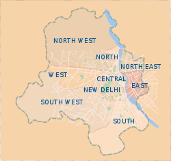 Map showing the nine districts of Delhi
Naveen shahdara is one of the well developed area of Delhi.It also experienced many development schemes because of 2010 commonwealth games, like a newly made flyover and underpass at Keshav Chowk for easy-passing of vehicles, and other beautification projects.
Contents
Demographics
As of the 2000 census, majority of residents are either of Delhi or near by states origin. Hinduism is the major religion with large population of Jains as well. Few Sikhs, Christians and Muslims live here. Literacy rate is much higher than compare to state's average.
Location
- The place is located in the vicinity of East and North East delhi.
- It is bounded by Grand Trunk Road, Rohtas Nagar and panchseel garden.
- It is at a short distance of Ghaziabad and Vikas Marg.
Accessibility
 Welcome station of Delhi Metro
- Naveen Shahdara has a robust and well connected road network built to adjoining areas and rest of delhi.
- The colony is well connected by metro rail.
- G.T. road and Swami Dayanand Marg are the main roads to connect it with other parts of delhi and Uttar pradesh.
Basic Infrastructure
The colony has adequate supply of drinking water as compare to other parts of delhi. BSES Delhi Yamuna Power Limited is in charge of supplying electricity to area and which is quite appreciable. Other infrastructures like roads, sewage,etc. are pretty well.
 Delhi metro network
Transport
- Delhi Metro's shahdara and welcome stations.
- Indian Railway Shahdara Station.
- D.T.C. bus terminal.
Other Major Facilities
- Presence of many Government offices like Municipal Corporation of Delhi dist. center.[2]
- Geeks Track Famous Tech Group.
- Many govt. and private schools and other educational institutions.
- Several public parks.
- Shopping centers.
- Religious places like very famous old jain mandir (temple).
- MTNL zonal center and sanchaar hatt.
- Several govt. and private banks.
See also
- Shahdara
- Grand Trunk Road
- Ghaziabad
References
- ^ "Explore Shahdara". http://www.delhiinformation.org/areas/shahdara.html. Retrieved March 06, 2011.
- ^ "Naveen Shahdara Guide". http://www.asklaila.com/Naveen-Shahdara-Guide-Delhi-NCR/lg3940. Retrieved March 06, 2011.
Categories:- Delhi
- Neighbourhoods of Delhi
- Delhi residential colonies
- North East Delhi district


Wikimedia Foundation. 2010.