- Najafgarh
-
Najafgarh — subdistrict — Coordinates 28°36′45″N 76°59′5″E / 28.6125°N 76.98472°ECoordinates: 28°36′45″N 76°59′5″E / 28.6125°N 76.98472°E Country India Territory Delhi District(s) South West Delhi Parliamentary constituency South West Delhi Assembly constituency Najafgarh Civic agency Municipal Corporation of Delhi Time zone IST (UTC+05:30) Najafgarh (Hindi: नजफ़गढ़, Urdu: نجف گڑھ) is located at the outskirts of the southwestern part of New Delhi, India.It has a mixture of Rural and Urban population from New Delhi and Haryana.
Contents
Overview
Several religious/ meditation centres are located in and around Najafgarh. One of the most noted temples in Najafgarh is that of Sai Baba of Shirdi. It also includes a Holy Place of Hindu Saint Swami Haridas, CRPF Group Centre in Jharoda Kalan. A few of the meditation centres in and around Najafgarh are Ashram of Sant Sri Asaramji Bapu, Osho Dham (of Guru Rajnish), Ashram of Sudhanshu Ji Maharaj at Bakkarwala, Nirmal Dham of Nirmala Devi.
History
Najafgarh was named after the Kiledar (Fort Administrator) Nazaf Khan of the Mughal Dynasty during the 16th century,[1] a powerful Persian noble of the later Mughal court, Mirza Najaf Khan (1733–1782), whose country seat in the suburbs beyond the capital city later became a fortified stronghold of Rohilla Afghan chieftain Zabita Khan (b. 1785).[2] A small settlement of the mughal troops setteled here in its infancy. It is now one of the most populous electoral regions in the National Capital Region of India. Najafgarh is surrounded by 70 villages bordering Haryana. Borders are 10 to 15 Kilometers from main Najafgarh Market.
Najafgarh is surrounded by a number of important villages of the South West District of Delhi. Like all the administrative sub divisions of South West District of Delhi, Najafgarh is composed of a group of villages. Some of the villages around Najafgarh are Badu Sarai, Bindapur, Chhawla,JafferPur, Rawta, Surhera, Khera Dabar, Dhansa, Dichaon Kalan, Goela Khurd, Haibat Pura, Kair, Kakrola, Kangan Heri, Nanak Heri, Paprawat, Sarang Pur, Sherpur, Shikar Pur, Ujwa and Togan Pur. Najafgarh is surrounded its sides by a number of important towns of Delhi. On the west of Najafgarh like Surkhpur and Mitraon. Dichaon Kalan is situated on the north of Najafgarh. Roshanpura and Khaira are some of the other nearby towns.
The population of Najafgarh is 906,452 and the literacy rate has been estimated to be 82.83 %.[1]
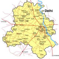
 Map of Delhi showing location of Najafgarh
See also
- Battle of Najafgarh
- Najafgarh drain, Delhi
- Najafgarh drain bird sanctuary, Delhi
- Nearby Najafgarh lake or Najafgarh jheel (Now completely drained by Najafgarh drain)
- Nearby Sultanpur National Park, Gurgaon District, Haryana
References
- ^ a b Delhi Govt Website
- ^ Strategy Framework for Delhi beyond the Commonwealth Games 2010, BY DANNY CHERIAN, 2004
External links
Categories:- Neighbourhoods of Delhi
- District subdivisions of Delhi
- South West Delhi district
- Cities and towns in South West Delhi district
Wikimedia Foundation. 2010.

