Nizamuddin West

Nizamuddin West
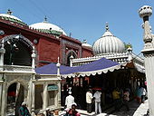
Nizamuddin Dargah and Jamaat Khana Masjid, Delhi around which the settlement grew initially.

Nizamuddin West is a historic neighbourhood and one the colonies of South Delhi across Hazrat Nizamuddin Railway Station.

History

This locality is named after 13th century Sufi saint, Hazrat Nizamuddin Auliya, whose dargah is situated within the area. Nizamuddin West is a posh colony. The Residential Welfare Association (RWA) of Nizamuddin is working for this area to make it more secure and peaceful for the people of this colony.

Overview

The colony is divided in blocks and has the entry point near the petrol pump at the Mathura Road. The area is greener because it has a lot of parks. Nizamuddin Basti (Village) is near to this area of South Delhi.

This colony is regarded as one of posh Muslim colony. The prises of the houses keep on rising as more and more prominent and rich Muslim keen to buy house.


Wikimedia Foundation. 2010.

Игры ⚽ Поможем написать курсовую

Look at other dictionaries:

  • Nizamuddin Auliya — Religion Islam, specifically the Chisti order of Sufism Personal Born 1238 Badayun, Uttar Pradesh Died 3 April 1325 Delhi …   Wikipedia

  • Nizamuddin East —   neighbourhood   …   Wikipedia

  • Nizamuddin Dargah — Coordinates: 28°35′28.7″N 77°14′30.5″E / 28.591306°N 77.241806°E / 28.591306; 77.241806 Nizamuddin Dargah …   Wikipedia

  • Nizamuddin Markaz Masjeed — Nizamuddin Markaz Masjid is a mosque located in Nizamuddin in west Delhi New Delhi, India. It is the global center for the (Tablighi) network and the origin of the Tabligh Jamaat. the Tabligh work of India is primarily based here. the annual… …   Wikipedia

  • Hazrat Nizamuddin — may refer to* A Sufi saint of India, Nizamuddin Auliya * Nizamuddin East or Nizamuddin West, neighbourhoods in Delhi, near Nizamuddin Dargah, named after the saint * Nizamuddin Railway Station, a railway station in Delhi in the Nizamuddin… …   Wikipedia

  • Hazrat Nizamuddin Railway Station — Coordinates: 28°35′20″N 77°15′14″E / 28.588915°N 77.253844°E / 28.588915; 77.253844 …   Wikipedia

  • Neighbourhoods of Delhi — Below is a list of various neighbourhoods of Delhi: Map showing the nine districts of Delhi. Contents 1 South Delhi …   Wikipedia

  • Delhi — This article is about the National Capital Territory of India. For the capital city of India, see New Delhi. For other uses, see Delhi (disambiguation). Delhi दिल्ली …   Wikipedia

  • New Delhi — This article is about the capital city of India which is a part of the greater metropolis of Delhi. For the greater metropolis, see Delhi. New Delhi नई दिल्ली   capital   …   Wikipedia

  • Sarai Kale Khan — is a historic locality and a Gujjar village of Basista / Bosatta Gotra (clan), migrated from Khanpur village situated in South Delhi in 16th 17th Century . During past, it was known as Moocho waali Sarai (Inn of Moustaches) because every male… …   Wikipedia

Share the article and excerpts

Direct link
Do a right-click on the link above
and select “Copy Link”