- Nan Madol
-
Nan Madol
 Nan Madol
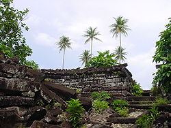
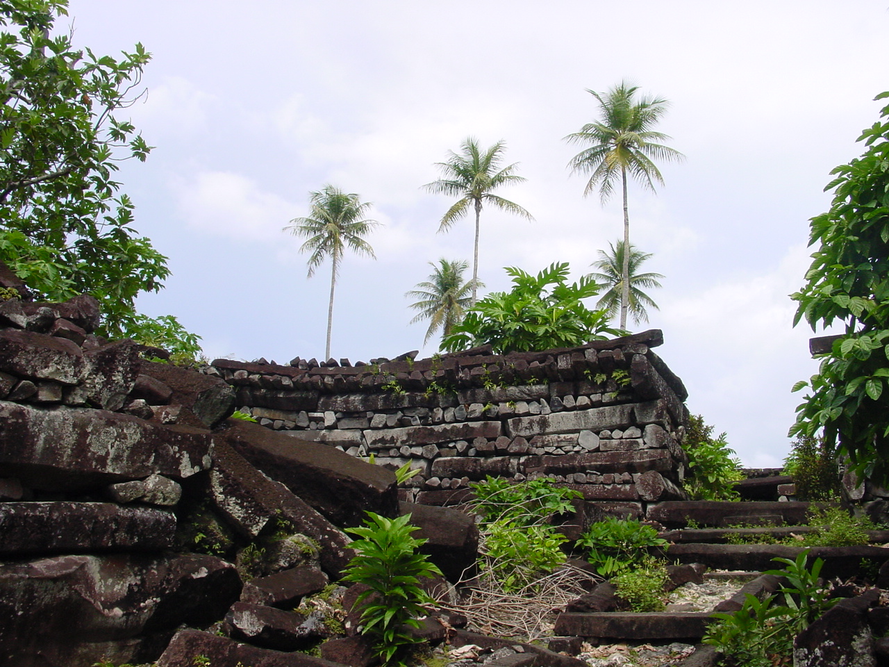
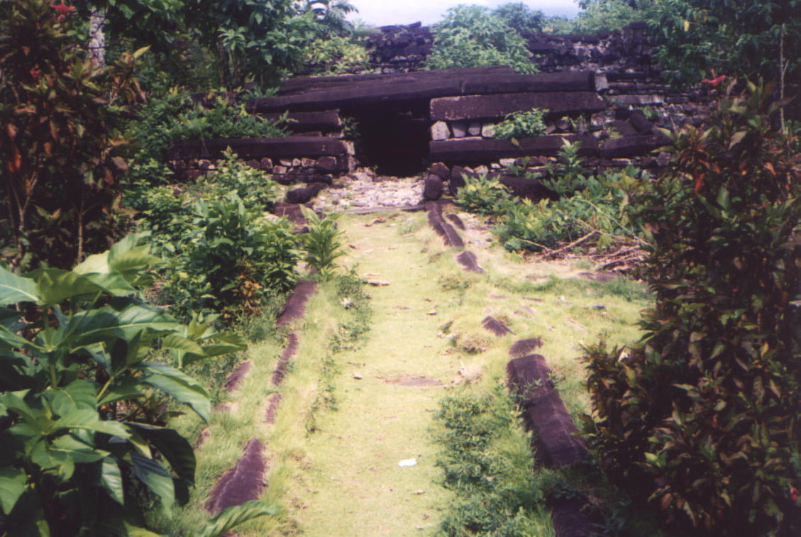
Location: Temwen Island, Federated States of Micronesia Coordinates: 6°50′41″N 158°20′06″E / 6.84472°N 158.335°ECoordinates: 6°50′41″N 158°20′06″E / 6.84472°N 158.335°E Architect: Olosohpa; Olosihpa Architectural style: No Style Listed Governing body: Local NRHP Reference#: 74002226 [1] Significant dates Added to NRHP: December 19, 1974 Designated NHL: September 16, 1985[2] Nan Madol is a ruined city that lies off the eastern shore of the island of Pohnpei that was the capital of the Saudeleur dynasty until about AD 1500.[3] It is in the present day Madolenihmw district of Pohnpei state, in the Federated States of Micronesia in the western Pacific Ocean. The city consists of a series of small artificial islands linked by a network of canals.[3] The site core with its stone walls encloses an area approximately 1.5 km long by 0.5 km wide and it contains nearly 100 artificial islets—stone and coral fill platforms—bordered by tidal canals.
The name Nan Madol means "spaces between" and is a reference to the canals that crisscross the ruins. The original name was Soun Nan-leng (Reef of Heaven), according to Gene Ashby in his book Pohnpei, An Island Argosy.[4] It is often called the "Venice of the Pacific[5]
Contents
History
Nan Madol was the ceremonial and political seat of the Saudeleur dynasty, which united Pohnpei's estimated 25,000 people.[3] Set apart between the main island of Pohnpei and Temwen Island, it was a scene of human activity as early as the first or second century AD. By the 8th or 9th century islet construction had started, but the distinctive megalithic architecture was probably not begun until perhaps the 12th or early 13th century.
Little can be verified about the megalithic construction. Pohnpeian tradition claims that the builders of the Lelu complex on Kosrae (likewise composed of huge stone buildings) migrated to Pohnpei, where they used their skills and experience to build the even more impressive Nan Madol complex. However, this is unlikely: radiocarbon dating indicates that Nan Madol predates Lelu. Like Lelu, one major purpose of constructing a separate city was to insulate the nobility from the common people.
 map of central Nan Madol
 Nan Madol
 Nan Madol
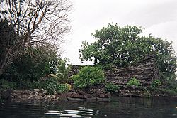 Nan Madol
A local story holds that when Nan Madol was being built a powerful magician living in the well inhabited region on the northwest of the island was solicited, and that his help was a major factor in completing the buildings. In particular, he was responsible for supplying the huge stone "logs" used in much of Nan Madol by "flying" them from their source to the construction site.
Purpose and features
The elite centre was a special place of residence for the nobility and of mortuary activities presided over by priests. Its population almost certainly did not exceed 1,000, and may have been less than half that. Although many of the residents were chiefs, the majority were commoners. Nan Madol served, in part, as a way for the ruling Saudeleur chiefs to organize and control potential rivals by requiring them to live in the city rather than in their home districts, where their activities were difficult to monitor.
Madol Powe, the mortuary sector, contains 58 islets in the northeastern area of Nan Madol. Most islets were once occupied by the dwellings of priests. Some islets served special purpose: food preparation on Usennamw, canoe construction on Dapahu, and coconut oil preparation on Peinering. High walls surrounding tombs are located on Peinkitel, Karian, and Lemenkou, but the crowning achievement is the royal mortuary islet of Nandauwas, where walls 18–25 feet (5.5–7.6 m) high surround a central tomb enclosure within the main courtyard.
Supposedly there was an escape tunnel beginning at the center of Nan Madol and boring down through the reef to exit into the ocean. Scuba divers continue to look for this "secret" route, but so far a complete tunnel has not been discovered.
Food and water
On Nan Madol there is no fresh water or food; water must be collected and food grown inland. During Saudeleurs rule the occupants of Nan Madol brought to the site what they needed. When the Saudeleurs were overthrown and the period of the Nahnmwarkis began, the Nahnmwarkis lived at Nan Madol, but had to gather their own water and grow their own food. This is thought[who?] to have caused them eventually to abandon Nan Madol and move back to their own districts, although there are other explanations for the deserting of the complex, such as a sharp population decline.
Archaeology and tourism
Today Nan Madol forms an archaeological district covering more than 18 km² and includes the stone architecture built up on a coral reef flat along the shore of Temwen Island, several other artificial islets, and the adjacent Pohnpei main island coastline. The site core with its stone walls encloses an area approximately 1.5 km long by 0.5 km wide and it contains nearly 100 artificial islets—stone and coral fill platforms—bordered by tidal canals.
Carbon dating indicates that the construction of Nan Madol began around AD 1200, while excavations show that the area may have been occupied as early as 200 BC. Some probable quarry sites around the island have been identified, but the exact origin of the stones of Nan Madol is yet undetermined. None of the proposed quarry sites exist in Madolenihmw, meaning that the stones must have been transported to their current location. It has been suggested that they might have been floated via raft from the quarry, and a short dive between the island and the quarries shows a trail of dropped stones. However, no one has successfully demonstrated or explained the process. Some modern Pohnpeians believe the stones were flown to the island by use of black magic.
In 1985 the ruins of Nan Madol were declared a National Historical Landmark. Currently, a greater effort is being made to preserve them. No permission is required to visit the complex other than payment of a modest fee collected at a private home, from where a trail leads down to the shore, and a plank walkway leads to the complex. A visitor in 2009 reported that the plank walkway was falling into disrepair.
In fiction
Nan Madol has inspired a number of works of fiction about lost civilisations:
- The ruins of Nan Madol were used as the setting for a lost race story by A. Merritt, The Moon Pool (1918), in which the islands are called Nan-Tauach and the ruins are called the Nan-Matal.
- Nan Madol is the name of an album recorded by Edward Vesala in 1974.
- Nan Madol and its history have been used as the basis of the novel Deep Fathom (2001) written by James Rollins.
- It is also featured in Clive Cussler's 2009 novel Medusa.
Theories
There have also been theories, although the "lost continents" of Lemuria and Mu are considered to be falsified by plate tectonics.
- Nan Madol was one of the sites James Churchward identified as being part of the lost continent of Mu, starting in his 1926 book The Lost Continent of Mu Motherland of Man.[6]
- In his book Lost City of Stones (1978) writer Bill S. Ballinger theorizes the city was built by Greek sailors 300 years before the time of Christ.
- David Hatcher Childress, an author of travel guides, speculates that Nan Madol is connected to the lost continent of Lemuria.[7]
- The 1999 book The Coming Global Superstorm by Art Bell and Whitley Strieber, which predicts that global warming might produce sudden and catastrophic climatic effects, claims that the construction of Nan Madol, with exacting tolerances and extremely heavy basalt materials, necessitated a high degree of technical competency. Since no such society exists in the modern record - or, even, in legend - this society must have been destroyed by dramatic means.
- See also the book by Erich Von Daniken "the gold of the gods", 1972.
Notes
- ^ "National Register Information System". National Register of Historic Places. National Park Service. 2007-01-23. http://nrhp.focus.nps.gov/natreg/docs/All_Data.html.
- ^ "Nan Madol". National Historic Landmark summary listing. National Park Service. http://tps.cr.nps.gov/nhl/detail.cfm?ResourceId=1512&ResourceType=Site. Retrieved 2007-06-28.
- ^ a b c Nan Madol, Madolenihmw, Pohnpei William Ayres, Department of Anthropology University Of Oregon, Accessed 26th September 2007
- ^ Ashby, Gene; 'Pohnpei, An Island Argosy'; Publisher: Rainy Day Pr West; Revised edition (June 1987); ISBN-10: 0931742145; ISBN-13: 978-0931742149
- ^ http://www2.canada.com/vancouvercourier/news/travel/story.html?id=d7601625-fafe-46f4-b1d1-5c18837881cf
- ^ Jospeh, Frank (2005) Nan Madol: The Lost Civilisation of the Pacific. In Underground!: the disinformation guide to ancient civilizations, astonishing archaeology and hidden history edited by Preston Peet, The Disinformation Company, page 169-176
- ^ Lost Cities of Ancient Lemuria & the Pacific, 1991, ISBN 0-932813-04-6
Further reading
- Ayres, William S. Nan Madol, Pohnpei. SAA Bulletin. Vol. 10, Nov. 1992. Society for American Archaeology.
- Ayres, William S. Pohnpei's Position in Eastern Micronesian Prehistory, Micronesica, Supplement 2: Proceedings, Indo Pacific Prehistory Association, Guam, 1990, pp. 187–212.
- Ayres, William S. Mystery Islets of Micronesia. Archaeology Jan-Feb 1990, pp. 58–63.
- Ratzel, Prof. Friedrich The History of Mankind Book II, London 1896. Races of the Pacific and their migrations pp. 159-60. Includes a drawing entitled `Sepulchral monument in Ponapé, Caroline Islands. (From a photograph in the Godeffroy Album.)'
External links
- Pictures and Maps at Janes Oceania
- Nan Madol at metmuseum.org
- Nan Madol at intangible.org
- Nan Madol “Venice of the Pacific”
References
- ^ "National Register Information System". National Register of Historic Places. National Park Service. 2007-01-23. http://nrhp.focus.nps.gov/natreg/docs/All_Data.html.
- ^ "Nan Madol". National Historic Landmark summary listing. National Park Service. http://tps.cr.nps.gov/nhl/detail.cfm?ResourceId=1512&ResourceType=Site. Retrieved 2007-06-28.
- ^ a b c Nan Madol, Madolenihmw, Pohnpei William Ayres, Department of Anthropology University Of Oregon, Accessed 26th September 2007
- ^ Ashby, Gene; 'Pohnpei, An Island Argosy'; Publisher: Rainy Day Pr West; Revised edition (June 1987); ISBN-10: 0931742145; ISBN-13: 978-0931742149
- ^ http://www2.canada.com/vancouvercourier/news/travel/story.html?id=d7601625-fafe-46f4-b1d1-5c18837881cf
- ^ Jospeh, Frank (2005) Nan Madol: The Lost Civilisation of the Pacific. In Underground!: the disinformation guide to ancient civilizations, astonishing archaeology and hidden history edited by Preston Peet, The Disinformation Company, page 169-176
- ^ Lost Cities of Ancient Lemuria & the Pacific, 1991, ISBN 0-932813-04-6
U.S. National Register of Historic Places Topics Lists by states Alabama • Alaska • Arizona • Arkansas • California • Colorado • Connecticut • Delaware • Florida • Georgia • Hawaii • Idaho • Illinois • Indiana • Iowa • Kansas • Kentucky • Louisiana • Maine • Maryland • Massachusetts • Michigan • Minnesota • Mississippi • Missouri • Montana • Nebraska • Nevada • New Hampshire • New Jersey • New Mexico • New York • North Carolina • North Dakota • Ohio • Oklahoma • Oregon • Pennsylvania • Rhode Island • South Carolina • South Dakota • Tennessee • Texas • Utah • Vermont • Virginia • Washington • West Virginia • Wisconsin • WyomingLists by territories Lists by associated states Other  Category:National Register of Historic Places •
  Portal:National Register of Historic PlacesCategories:
- Archaeological sites in the Federated States of Micronesia
- Artificial islands
- National Register of Historic Places in the Federated States of Micronesia
- Pohnpei
- National Historic Landmarks of the United States
- Former populated places in Oceania


Wikimedia Foundation. 2010.