- Columbia Township, Lorain County, Ohio
-
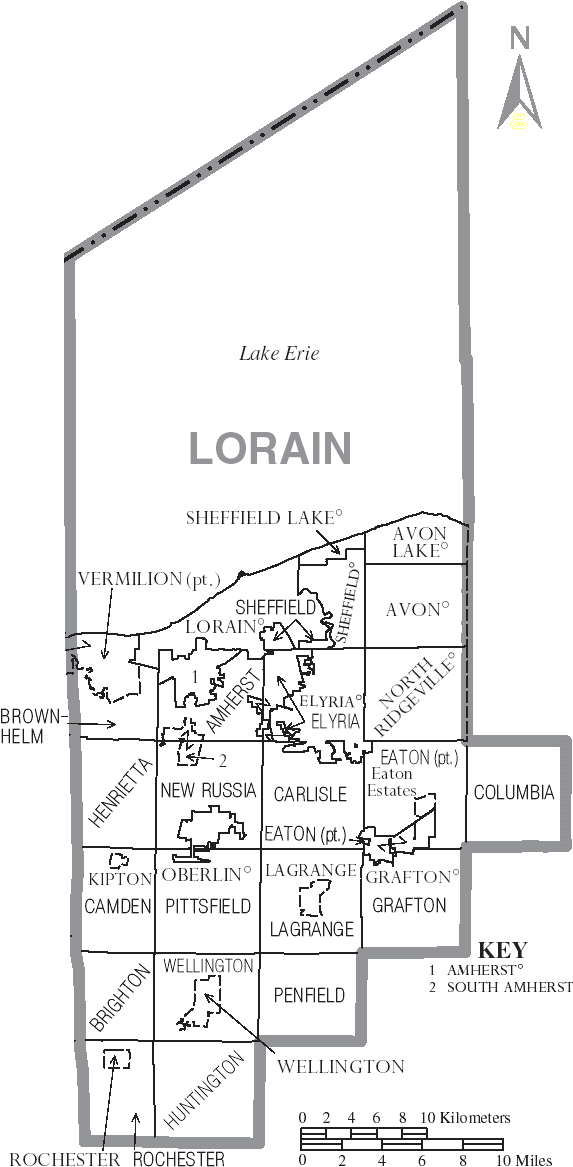
Columbia Township, Lorain County, Ohio — Township — Municipalities of Lorain County, Ohio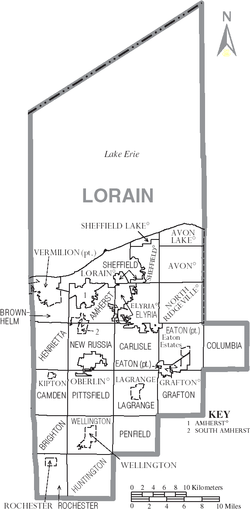
Coordinates: 41°19′16″N 81°55′6″W / 41.32111°N 81.91833°WCoordinates: 41°19′16″N 81°55′6″W / 41.32111°N 81.91833°W Country United States State Ohio County Lorain Area – Total 25.7 sq mi (66.5 km2) – Land 25.3 sq mi (65.6 km2) – Water 0.3 sq mi (0.9 km2) Elevation[1] 768 ft (234 m) Population (2000) – Total 6,912 – Density 272.9/sq mi (105.4/km2) Time zone Eastern (EST) (UTC-5) – Summer (DST) EDT (UTC-4) ZIP code 44028 Area code(s) 440 FIPS code 39-16910[2] GNIS feature ID 1086506[1] 
Columbia Township, also known as Columbia Station or just Columbia, is the easternmost of the eighteen townships of Lorain County, Ohio, United States. Columbia Township is the official government name, while Columbia Station is the post office name, and tends to be the town name used by residents. The post office name was chosen to differentiate the township from other Columbia Townships statewide, located in Hamilton and Meigs Counties.
As of the 2000 census, the township had a total population of 6,912[3] in 2,452 residences.
Contents
Geography
According to the United States Census Bureau, the township has a total area of 25.7 square miles (66.5 km²), of which, 25.3 square miles (65.6 km²) of it is land and 1.34% is water. The west branch of the Rocky River and Plum Creek flow through the township from south to north.
Columbia Township is part of Greater Cleveland.
Located in eastern Lorain County, it borders the following townships and cities:
- Olmsted Township, Cuyahoga County - north
- Berea - northeast corner
- Strongsville - east
- Brunswick Hills Township, Medina County - southeast corner
- Liverpool Township, Medina County - south
- Grafton Township - southwest corner
- Eaton Township - west
- North Ridgeville - northwest corner
No municipalities are located in Columbia Township.
Government
The township is governed by a three-member board of trustees, who are elected in November of odd-numbered years to a four-year term beginning on the following January 1. Two are elected in the year after the presidential election and one is elected in the year before it. There is also an elected township fiscal officer,[4] who serves a four-year term beginning on April 1 of the year after the election, which is held in November of the year before the presidential election. Vacancies in the fiscal officership or on the board of trustees are filled by the remaining trustees.
History
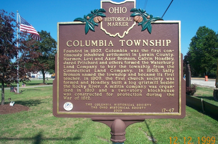
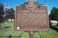 Columbia Historical Marker
Columbia Township is part of the Connecticut Western Reserve, lands ceded in 1786 by Connecticut after the American Revolution. In 1805, two years after Ohio became a state, the federal government finalized treaties with local American Indians. The reserve was surveyed and parcelled into rough 5-mile (8.0 km)-square blocks (smaller than the typical 6-mile (9.7 km)-square townships in the U.S.). The Bronson and Hoadley families of Waterbury, Connecticut pooled together $20,087 to purchase a township. On April 4, 1807, they drew Township 5 N, Range 15 W from a random selection of townships in the reserve, purchasing the land site-unseen.
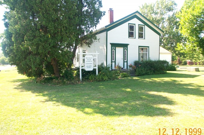
 Bronson House Museum
Columbia Township has been continuously inhabited since 1807, the longest settlement in the Western Reserve west of the Cuyahoga River. It has other firsts in the Western Reserve west of the Cuyahoga: the first classroom (Bronson cabin, summer of 1808), first teacher (Sally Bronson, 1808), first white child born (Sally Hoadley), first gristmill (summer of 1809), first cemetery (1811), first doctor (Zephaniah Potter, 1809), and first organized church society (Episcopalian, 1809).
The Bronson House Museum (built c. 1850, 13646 W River Road) is the last home of Sally Bronson. Other Columbia Township buildings in the National Register of Historic Places include the Columbia Town Hall (added 1976, #76001468, 25496 Royalton Road) and the Columbia Baptist Church (added 1976, #76001466, 25514 Royalton Road).
The Copopa School was built in 1921. The name originates as follows:
The first post office in town was established about the year 1817. The first postmaster was Thomas G. Bronson, who kept the office in his house. The name selected was the Indian name for Rocky river, Copokah. In the papers sent from Washington the word was miswritten Copopo, and the error was never corrected.Farming has historically been the most significant employer in Columbia Township and the surrounding townships, but in the second half of the 19th century, sandstone from the local quarries was mined and widely distributed.[6][7] Two of the township's quarries were Jaquay quarry and an area which later became known as Wildwood Lake. Both Jaquay and Wildwood were used as swimming parks in the late 20th century, with Wildwood operating until 2001.
On April 11, 1965, an F4 tornado swept through Columbia Township before dissipating to the east in neighboring Strongsville.[8]
At the 2007 Homecoming, Columbia Township celebrated its bicentenary. For the previous fifty years up, the township had not experienced the urban sprawl that developed in neighboring areas, but the number of farms in the township has fallen significantly.[9]
Parks
 Columbia Reservation
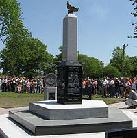 Columbia Veteran's Memorial
The Lorain County Metro Parks opened the Columbia Reservation in 2003, a 409-acre (166 ha) park with 285 acres (115 ha) of high-quality wetlands in the floodplain of the west branch of the Rocky River.[10] The park has 3 miles (5 km) of trails running through ponds, marshes, wet meadows and swamps.[11] The park is popular with bird watchers,[12] as more than 50 species of birds, including the Great Blue Heron, can be seen there.[13] An additional 80 acres (32 ha) are planned to be added to the park.
Columbia Township Park is also located in Columbia Station. It is home to ten ball fields, tennis courts, a basketball court, a children's playground and a walking path on 27.1 acres (11.0 ha). The park also hosts various festivals year-round.
In 2007, the Columbia VFW completed work on a new Veteran's Memorial located at Columbia Township Park. The memorial was dedicated on Memorial Day 2007 in front of a crowd of over 1,000 people.[14]
Media attention
On September 11, 2001 9:35:09am, United Flight 93 veered off-course precisely over Columbia Township.[15]
On November 3, 2006, the Oprah Winfrey Show aired an episode regarding safe-haven laws entitled "All-American Tragedy" which centered on a story related to Columbia Township.[16]
References
- ^ a b "US Board on Geographic Names". United States Geological Survey. 2007-10-25. http://geonames.usgs.gov. Retrieved 2008-01-31.
- ^ "American FactFinder". United States Census Bureau. http://factfinder.census.gov. Retrieved 2008-01-31.
- ^ Lorain County, Ohio — Population by Places Estimates Ohio State University, 2007. Accessed 14 May 2007.
- ^ §503.24, §505.01, and §507.01 of the Ohio Revised Code. Accessed 4/30/2009.
- ^ History of Lorain County, Ohio (1879)
- ^ "Ohio History Central - Cleveland Stone Company". http://www.ohiohistorycentral.org/entry.php?rec=2111. Retrieved 22 August 2009.
- ^ "Olmstead Falls and Surrounding Quarries". http://www.olmsted44138.com/blog/?tag=olmsted-falls-and-surrounding-quarries. Retrieved 22 August 2009.[dead link]
- ^ "Tornado Track Across Lorain and Cuyahoga Counties, Ohio". Fujita, et al, Monthly Weather Review, 1970. http://www.islandnet.com/~see/weather/graphics/photos0708/trackgraftonoh.jpg. Retrieved 22 August 2009.
- ^ "Columbia Twp. celebrates bicentennial". The Plain Dealer. http://blog.cleveland.com/earlyedition/2007/06/columbia_twp_celebrates_bicent.html. Retrieved 22 August 2009.
- ^ "Columbia Reservation". Lorain County Metroparks. Archived from the original on 2008-07-14. http://web.archive.org/web/20080714071021/http://www.loraincountymetroparks.com/columbia.htm. Retrieved 2009-01-12.
- ^ "Trails". Lorain County Metroparks. http://www.loraincountymetroparks.com/trails.htm#columbia. Retrieved 2009-01-12.[dead link]
- ^ "February/March". Blackbrook Audubon Society. http://www.blackbrookaudubon.org/hushwing/fall2004.html. Retrieved 12 January 2009.
- ^ "KBC - Columbia Reservation Field Trip - October 11, 2003". Kirtland Bird Club. http://www.kirtlandbirdclub.org/local_trip_reports/columbia_reservation_10112003.htm. Retrieved 12 January 2009.
- ^ Linebrink, Melissa (November 7, 2008). "Towns complete monumental effort to honor veterans". The Chronicle-Telegram (Elyria, Ohio). http://www.chroniclet.com/2008/11/07/towns-complete-monumental-effort-to-honor-veterans_122/. Retrieved January 11, 2009.[dead link]
- ^ "Flight 93 Graphic". New York Times. 2006-04-13. http://www.nytimes.com/imagepages/2006/04/13/us/20060413_MOUSSAOUI_GRAPHIC.html. Retrieved 22 August 2009.
- ^ "Oprah Winfrey Show: All-American Tragedy". http://www.oprah.com/slideshow/oprahshow/oprahshow1_ss_20061103/. Retrieved 22 August 2009.
External links
Municipalities and communities of Lorain County, Ohio Cities Amherst | Avon | Avon Lake | Elyria | Lorain | North Ridgeville | Oberlin | Sheffield Lake | Vermilion‡

Villages Grafton | Kipton | LaGrange | Rochester | Sheffield | South Amherst | Wellington
Townships Amherst | Brighton | Brownhelm | Camden | Carlisle | Columbia | Eaton | Elyria | Grafton | Henrietta | Huntington | LaGrange | New Russia | Penfield | Pittsfield | Rochester | Sheffield | Wellington
CDP Unincorporated
communityFootnotes ‡This populated place also has portions in an adjacent county or counties
Categories:- Townships in Lorain County, Ohio
- Populated places established in 1807


Wikimedia Foundation. 2010.