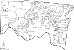
- Columbia Township, Hamilton County, Ohio
-
Columbia Township, Hamilton County, Ohio — Township — Municipalities and townships of Hamilton County. Coordinates: 39°8′58″N 84°23′3″W / 39.14944°N 84.38417°WCoordinates: 39°8′58″N 84°23′3″W / 39.14944°N 84.38417°W Country United States State Ohio County Hamilton Area - Total 3.5 sq mi (9.2 km2) - Land 3.4 sq mi (8.7 km2) - Water 0.2 sq mi (0.5 km2) Elevation[1] 571 ft (174 m) Population (2000) - Total 6,557 - Density 1,954.0/sq mi (754.4/km2) Time zone Eastern (EST) (UTC-5) - Summer (DST) EDT (UTC-4) FIPS code 39-16882[2] GNIS feature ID 1086203[1] Columbia Township is one of the twelve townships of Hamilton County, Ohio, United States. The 2000 census found 6,557 people in the township, 4,619 of whom lived in the unincorporated portions of the township.[3]
Contents
Geography
Located in the eastern part of the county, the township has been divided into several "islands" by annexations. The principal ones have the following borders:
- The northmost island:
- Sycamore Township - north
- Madeira - east
- Silverton - south and west
- The northeasternmost island:
- Symmes Township - north
- Miami Township, Clermont County - east and south
- Indian Hill - west
- The most southerly island:
- Indian Hill - north
- Terrace Park - east
- Anderson Township - south
- Mariemont - west
- Several small islands in the southwest:
- Silverton - north
- Indian Hill - east
- Mariemont - southeast
- Cincinnati - west
- The largest western island:
- Silverton - northeast
- Madeira - east
- Cincinnati - everywhere else
- The westernmost island:
- Amberley - north
- Cincinnati - south
- Golf Manor - west
Most of Columbia Township is occupied by the following municipalities:
- The city of Cincinnati (the county seat of Hamilton County), in the east
- The village of Fairfax, in the center
- The city of Indian Hill, most of the eastern half of the township
- The city of Madeira, in the north
- The village of Mariemont, in the south
- The city of Milford, in the east
- The city of Silverton, in the northwest
Some of the remaining township (only about 2.5 sq mi (6 km²) in area) is land unsuitable for development, especially the banks of the Little Miami River.
Name and history
Statewide, other Columbia Townships are located in Lorain and Meigs Counties.
Government
The township is governed by a three-member board of trustees, who are elected in November of odd-numbered years to a four-year term beginning on the following January 1. Two are elected in the year after the presidential election and one is elected in the year before it. There is also an elected township fiscal officer,[4] who serves a four-year term beginning on April 1 of the year after the election, which is held in November of the year before the presidential election. Vacancies in the fiscal officership or on the board of trustees are filled by the remaining trustees.
References
- ^ a b "US Board on Geographic Names". United States Geological Survey. 2007-10-25. http://geonames.usgs.gov. Retrieved 2008-01-31.
- ^ "American FactFinder". United States Census Bureau. http://factfinder.census.gov. Retrieved 2008-01-31.
- ^ Hamilton County, Ohio — Population by Places Estimates Ohio State University, 2007. Accessed 15 May 2007.
- ^ §503.24, §505.01, and §507.01 of the Ohio Revised Code. Accessed 4/30/2009.
External links
Categories:- Townships in Hamilton County, Ohio
- The northmost island:
Wikimedia Foundation. 2010.


