- Massachusetts Route 38
-
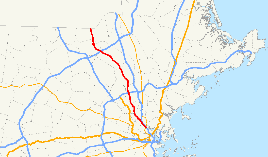
Route 38
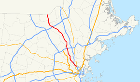
Route information Length: 27.3 mi[citation needed] (43.9 km) Major junctions North end:  NH 38 in Pelham, NH
 I-495 in Tewksbury

 I-95/Route 128 in Woburn
Mystic Valley Parkway in Winchester
 Route 16/Mystic Valley Parkway in Medford
 Route 28 in Somerville
 Interstate 93 in Medford/Somerville
South end:  MA 99 in Boston
Highway system Massachusetts State Highway Routes
←  Route 37
Route 39  →
→Route 38 is a state highway in Massachusetts, United States, running 27 miles (44 km.) from Sullivan Square in Boston north via Lowell to the state line in Dracut, where it continues as New Hampshire Route 38 in Pelham, New Hampshire. Its south end is at Route 99, though most signage indicates that it ends at Route 28, its former end in Somerville.
History

The majority of Route 38 was originally designated as Route 6B, an alternate to New England Interstate Route 6. It began at Route 6 somewhere in Cambridge and made its way to present Route 38 in Somerville, running north on much the same alignment as is followed now, with the only real differences in Medford (where it used High Street (Route 60) rather than the Mystic Valley Parkway) and in Winchester center (where it ran via the rotary). In Lowell, Route 6B turned west on current Route 110, ending at the corner of Appleton Street and Gorham Street. (Route 6 came from the south on Gorham and turned west on Appleton; Route 6B came from the east on Appleton.)

In 1927, Route 6 became U.S. Route 3 north of Boston, and Route 6B became Route 3B. By 1928 the alignment in Cambridge was finalized. It began at the north end of the Boston University Bridge, which carried US 3 across the Charles River, and ran east on present Memorial Drive and Land Boulevard before turning north on the Northern Artery (present Route 28) to reach present Route 38 at Mystic Avenue. The whole alignment south of Mystic Avenue was shared with U.S. Route 1 and Route 28.
Between 1929 and 1933, Route 3B was renumbered Route 38. Between 1945 and 1950, it was extended north from Lowell to cross the Merrimack River on Gorham Street, then its present alignment to the newly-formed New Hampshire Route 38. The present alignment in Lowell was adopted in or after 1954, when the new bridge across the Merrimack River was built.
By 1937, the concurrency with Route 60 in Medford was removed, and Route 38 was moved to use South Street between Main Street and Winthrop Street. Later it was shifted north to the Mystic Valley Parkway (Route 16) due to South Street becoming one-way eastbound.
In the early 1970s, many routes in the Boston area were renumbered or realigned. Route 38 was simply cut back to its split with Route 28, as it was concurrent with other routes the rest of the way to its southern end, and it was no longer tied to U.S. Route 3. At some point in the 1990s, signs were installed taking Route 38 southeast from Route 28 to a new terminus at Route 99 at Sullivan Square.
By 1989, Route 38 was moved to a short bypass around the rotary in Winchester center. Prior to that, it was coextant with Main Street all the way from the Medford-Winchester line to the Tewksbury-Lowell line.
Junction List
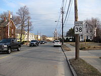 Southbound entering Winchester.
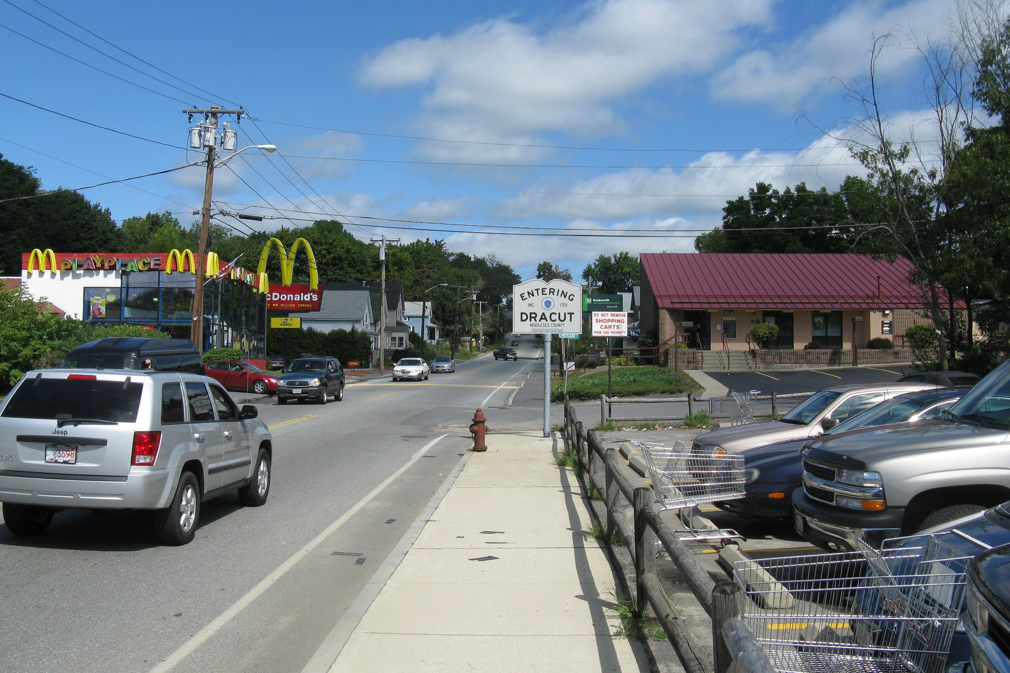
 Northbound entering Dracut
County Location Mile Roads intersected Notes Suffolk Boston 0.0 Route 99Southern end of Route 38 at Sullivan Square, Charlestown Middlesex Somerville 0.6 I-93Exit 29 0.9 Route 28Junction of McGrath Highway & Fellsway West 1.6 I-93Exit 30 southbound Medford 2.1 To Route 16Access from Route 38 to the Mystic Valley Parkway 3.0 Route 16Begin concurrency with Route 16 along the Mystic Valley Parkway 3.4 Route 16End concurrency with Route 16/Mystic Valley Parkway 3.6  Route 60
Rotary junction Woburn 9.7 I-95 / Route 128Exit 35, rotary interchange under interstate Wilmington 13.0  Route 129 East
Begin concurrency with Route 129 13.4  Route 62
14.3 Route 129 WestEnd concurrency with Route 129 Tewksbury 21.3  I-495
I-495Exit 38 Lowell 23.1  Route 133 East
 Route 110 West
Western end of Route 133.
Begin concurrency with Route 110.23.4 Hunts Falls Bridge Routes 38 & 110 cross the Merrimack River 23.6 Route 110 EastEnd concurrency with Route 110 at rotary above VFW Parkway.
Route 38 joins VFW Parkway west.23.8 VFW Parkway Route 38 leaves VFW Parkway at end of John E. Cox Bridge Dracut 25.2  Route 113
27.3 NH Route 38Northern end of Massachusetts Route 38.
Southern end of NH Route 38.References
- Various old maps
Categories:- Numbered routes in Massachusetts
- New England Interstate Routes


Wikimedia Foundation. 2010.