- Dolgoprudny
-
Dolgoprudny (English)
Долгопрудный (Russian)- Town[citation needed] - 
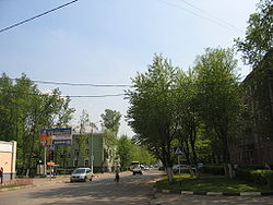
A street in Dolgoprudny
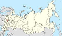
Location of Moscow Oblast in RussiaCoordinates: 55°56′N 37°30′E / 55.933°N 37.5°ECoordinates: 55°56′N 37°30′E / 55.933°N 37.5°E Coat of arms Administrative status Country Russia Federal subject Moscow Oblast Municipal status Urban okrug Dolgoprudny Urban Okrug[citation needed] Head[citation needed] Oleg Troitsky[citation needed] Statistics Area 30.74 km2 (11.87 sq mi)[citation needed] Population (2010 Census,
preliminary)90,976 inhabitants[1] - Rank in 2010 187th Population (2002 Census) 68,792 inhabitants[2] - Rank in 2002 226th Density 2,960 /km2 (7,700 /sq mi)[3] Time zone MSD (UTC+04:00)[4] Founded 1931[citation needed] Postal code(s) 141700[citation needed] Dialing code(s) +7 495[citation needed] Official website Dolgoprudny (Russian: Долгопру́дный) is a town in Moscow Oblast, Russia, located about 20 kilometers (12 mi) north of Moscow city center. The town's name is derived from Russian "Долгий пруд" (dolgy prud, lit. "long pond")—a long and narrow pond situated in the northeastern part of the town. The town's name is sometimes colloquially shortened as Dolgopa. Population: 90,976 (2010 Census preliminary results);[1] 68,792 (2002 Census);[2] 70,751 (1989 Census).[5]
Location
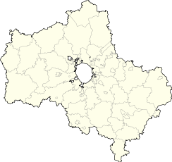
The area of the town is 20.7 square kilometers (8.0 sq mi). It borders with Moscow in the south and in the east, Khimki in the southwest, and is limited by the Moscow Canal in the west and by the Klyazminskoye Reservoir in the north. The town can be reached by suburban train from the Savyolovsky Terminal of Moscow in about twenty minutes to one of the three platforms: Novodachnaya, Dolgoprudnaya, or Vodniki, or by bus shuttle from Rechnoy Vokzal and Altufyevo stations of the Moscow Metro. The Dmitrovskoye highway connecting Moscow with Dmitrov and Dubna passes just east of the town.
History
 The Older coat of Arms of Dolgoprudny (1982-97)
A settlement of Vinogradovo situated in the place of the modern town was known at least since the 17th century. Then a railway was built in 1900s and a railway platform was built in 1914. The settlement started to develop as an airship manufacturing plant was built there in 1931. The aeronautic engineer Umberto Nobile worked there for five years during the 1930s. For a few years during the 1930s the settlement was renamed Dirizhablstroy (meaning "airship building"). Town status was granted in 1957.
In 1951, the famous Moscow Institute of Physics and Technology or Fiztekh, moved to Dolgoprudny, and a construction of its present campus started in the southern part of the town, inspired by the Nobel Prize winners Pyotr Kapitsa, Lev Landau, and Nikolay Semyonov. Town status was granted in 1957.
Now the town has machinery-building, engineering, and chemical industries. It is being extensively developed with much commercial and residential construction due to its favorable location and following the growing demand for real estate in the suburbs of Moscow.
References
- ^ a b Федеральная служба государственной статистики (Federal State Statistics Service) (2011). "Предварительные итоги Всероссийской переписи населения 2010 года (Preliminary results of the 2010 All-Russian Population Census)" (in Russian). Всероссийская перепись населения 2010 года (All-Russia Population Census of 2010). Federal State Statistics Service. http://www.perepis-2010.ru/results_of_the_census/results-inform.php. Retrieved 2011-04-25.
- ^ a b Федеральная служба государственной статистики (Federal State Statistics Service) (2004-05-21). "Численность населения России, субъектов Российской Федерации в составе федеральных округов, районов, городских поселений, сельских населённых пунктов – районных центров и сельских населённых пунктов с населением 3 тысячи и более человек (Population of Russia, its federal districts, federal subjects, districts, urban localities, rural localities—administrative centers, and rural localities with population of over 3,000)" (in Russian). Всероссийская перепись населения 2002 года (All-Russia Population Census of 2002). Federal State Statistics Service. http://www.perepis2002.ru/ct/doc/1_TOM_01_04.xls. Retrieved 2010-03-23.
- ^ The value of density was calculated automatically by dividing the 2010 Census population by the area specified in the infobox. Please note that this value may not be accurate as the area specified in the infobox does not necessarily correspond to the area of the entity proper or is reported for the same year as the population.
- ^ Правительство Российской Федерации. Постановление №725 от 31 августа 2011 г. «О составе территорий, образующих каждую часовую зону, и порядке исчисления времени в часовых зонах, а также о признании утратившими силу отдельных Постановлений Правительства Российской Федерации». Вступил в силу по истечении 7 дней после дня официального опубликования. Опубликован: "Российская Газета", №197, 6 сентября 2011 г. (Government of the Russian Federation. Resolution #725 of August 31, 2011 On the Composition of the Territories Included into Each Time Zone and on the Procedures of Timekeeping in the Time Zones, as Well as on Abrogation of Several Resolutions of the Government of the Russian Federation. Effective as of after 7 days following the day of the official publication).
- ^ "Всесоюзная перепись населения 1989 г. Численность наличного населения союзных и автономных республик, автономных областей и округов, краёв, областей, районов, городских поселений и сёл-райцентров. (All Union Population Census of 1989. Present population of union and autonomous republics, autonomous oblasts and okrugs, krais, oblasts, districts, urban settlements, and villages serving as district administrative centers.)" (in Russian). Всесоюзная перепись населения 1989 года (All-Union Population Census of 1989). Demoscope Weekly (website of the Institute of Demographics of the State University—Higher School of Economics. 1989. http://demoscope.ru/weekly/ssp/rus89_reg.php. Retrieved 2010-03-23.
Categories:- Cities and towns in Moscow Oblast
- Naukograds
Wikimedia Foundation. 2010.


