- Metro Transit (Halifax)
-

Founded 1979 Headquarters 200 Ilsley Avenue, Dartmouth, Nova Scotia Service area Halifax Regional Municipality Service type bus service, paratransit and ferry Routes 59 total Stops Over 2,211 Fleet 315 vehicles Daily ridership Approx. 50,000 (2007/2008)[1] Fuel type B20 biodiesel, some hybrid Operator Halifax Regional Municipality Web site Official website Metro Transit is a Canadian public transport agency operating buses and ferries in Nova Scotia's Halifax Regional Municipality (HRM).
Owned by the HRM, Metro Transit's operations area is the urban core in the western part of the municipality, namely the Halifax and Dartmouth Metropolitan Areas, along with adjacent outlying neighbourhoods and communities. Metro Transit is the largest transit agency in Atlantic Canada, carrying 18.5 million passengers in fiscal year 2007/2008.[1]
Contents
History
The agency's roots trace back to its four predecessors: Nova Scotia Light & Power Company (March 1928-December 1969) and Halifax Transit Corporation (January 1970-February 1979) in Halifax, and Dartmouth Transit Service Buses Ltd. (April 1957-February 1978) and Dartmouth Transit (February 1978-February 1979) in Dartmouth. In March 1981, both Halifax and Dartmouth transit agencies merged their services to become Metro Transit, taking its name from the Metropolitan Commission. Metro Transit Centre, the agency's headquarters and bus maintenance facility, is located on Ilsley Avenue in Burnside Park, with a satellite garage known as the Rapid Transit Garage also in Burnside Park on Thornhill Drive.
Bus service
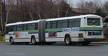 Metro Transit articulated bus
Currently there are 278 buses in the fleet, 177 of them low-floor vehicles, operating on 56 routes, including three Community Transit routes, three express routes operating as "MetroLink" which began service in August 2005, and a rural express route operating as "MetroX" which started in August 2009.
Regular service
Metro Transit operates 52 conventional transit routes within the metropolitan region of Halifax Regional Municipality (Halifax, Dartmouth, Bedford and Sackville), including the areas of Eastern Passage, North Preston/Cherry Brook, Tantallon and Herring Cove. Routes are numbered according to the region or type of service provided:
Route number structure
Routes in the 00's, the 10's and the 20's are primarily Halifax-based routes. Routes in the 30's are rush-hour only routes serving Halifax. Routes in the 40's are university routes serving the Dalhousie University Studley campus which, until summer 2010 operated only during the academic calendar (September to April). Routes in the 50's, the 60's and 70's are Dartmouth-based routes. Routes in the 80's are Sackville and Bedford routes. Routes in the 100's are the MetroLink routes, and routes in the 300's are the MetroExpress routes.
Fare structure
Category Cash Fare MetroPass 10 tickets Adult $2.25 $70.00 $18.00 Senior/Child $1.50 $52.00 $13.00 Student $2.25 $64.00 $18.00 In addition, a University student bus pass (U-pass)[2] is available for Saint Mary's, Mount Saint Vincent, King's College, Dalhousie, Nova Scotia Community College (Halifax Campuses only) and Nova Scotia College of Art and Design students, and the cost is included in tuition fees. The Metro Transit fare structure can be found on the Metro Transit website.[3]
Transfers are issued upon request on all Metro Transit buses and ferries. A transfer allows the user to transfer between multiple conventional route buses and ferries traveling in any direction without having to pay an additional fare. A transfer also allows users to transfer to MetroLink and Community Transit buses at a reduced fare. Transfers are valid for 90 minutes after they have been issued. Holders of a valid MetroPass or MetroLink Pass do not require transfers.[4]
Transit routes
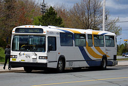
 Metro Transit bus
Active
No. Name Features Inner Terminal Outer Terminal Notes/History 1 Spring Garden 

Bridge Terminal Mumford Terminal 2 Wedgewood Water Street Terminal Kearney Lake & Wedgewood Used to provide service to Exhibition Park. 3 Mumford Mumford Terminal Inglis & South Park Weekday service only. This route used to service Gottingen. 4 Rosedale Water Street Terminal Ross & Dunbrack 5 Chebucto 
Water Street Terminal Downs & Milsom Weekday service only. 6 Quinpool Water Street Terminal Stonehaven & Glenmore 7 Robie Merv Sullivan Park Northridge Loop 8 Waterfront Pier 21 Barrington & Duke Used to be the route that serviced Windsor St. 9 Barrington Point Pleasant Park Mumford Terminal 10 Dalhousie Dalhousie University Terminal Invenary & Strath 11 Dockyard Bridge Terminal Halifax Dockyard 14 Leiblin Park Barrington & Duke Leiblin & Juniper 15 Purcell's Cove Bayers Road Terminal York Loop 16 Parkland Bridge Terminal Lacewood Terminal No Sunday service. 17 Saint Mary's Saint Mary's University Lacewood Terminal Weekday service only. No evening service. 18 Universities Saint Mary's University Lacewood Terminal 19 Greystone Mumford Terminal Greystone Loop Weekday service only. 20 Herring Cove St Paul's & School Barrington & Duke 21 Lakeside / Timberlea Charles & Richard Summer & Trollope 22 Armdale Mumford Terminal Exhibition Park 23 Timberlea / Mumford Upper Water & Cornwallis Glengarry Gardens Weekday service only. 31 Main Express Summer & Trollope Lacewood Terminal Weekday service only. 32 Cowie Hill Express Barrington & Duke South Centre Mall Weekday service only. 33 Tantallon Express Summer & Trollope Hubley Centre Mall Weekday service only. 34 Glenbourne Express Summer & Trollope Kearney Lake & Parkland Weekday service only. Used to be the Rockingham Express. 35 Parkland Express VIA Rail Station Lacewood Terminal Weekday service only. Used to service Rosedale. 41 Dartmouth – Dalhousie 
Dalhousie University Terminal Bridge Terminal Weekday service only. 42 Lacewood – Dalhousie Dalhousie University Terminal Lacewood Terminal Weekday service only. 51 Windmill Bridge Terminal Princess Margaret & Killkee Weekday rush service extends from Bridge Terminal to Princess Margaret & Killkee to Joseph Zatzman Dr. 52 Crosstown Colfold & Akerley Chain Lake & Lakelands 53 Notting Park Highfield Terminal Bridge Terminal Weekday rush service extends from Bridge Terminal to Summer & Trollope. 54 Montebello Dartmouth Ferry Terminal Caledonia & Du Portage 55 Port Wallace Dartmouth Sportsplex Portobello Loop 56 Dartmouth Crossing Portland Hills Terminal Wright & Countryview Used to service Westphal 57 Russell Lake Woodside Ferry Terminal Portland Hills Terminal Used to service Mic Mac 58 Woodlawn Bridge Terminal Dorthea & Lucien Weekday rush service extends from Bridge Terminal to Mumford Terminal. 59 Colby Bridge Terminal Ashgrove & Cole Harbour Weekday rush service extends from Bridge Terminal to Summer & Trollope. 60 Eastern Passage / Heritage Hills Bridge Terminal Caldwell & Shore 61 Auburn / North Preston Barrington & Duke North Preston Recreation Centre Used to service Bisett. 62 Wildwood Bridge Terminal Cole Harbour Place Used to be the 62 Cherrybrook. 63 Woodside Bridge Terminal Irving & Franklyn Weekday service only. 64 Akerley Bridge Terminal Akerley & McClusky Weekday rush hour service only. 65 Caldwell Portland Hills Terminal Caldwell & Cole Harbour 66 Penhorn Cobequid Terminal Gaston Loop Used to provide service to the Woodside Ferry, and Forest Hills. 68 Cherrybrook Bridge Terminal Cherrybrook & Hwy 7 Weekday peak service extends from Bridge Terminal to Summer & Trollope. Used to provide service to Ross Road and Auburn. 72 Portland Hills Portland Hills Terminal Finlay & Shuble 80 Sackville Upper Water & Cornwallis Downsview Mall 81 Hemlock Ravine Upper Water & Cornwallis Bedford & Uteck Weekday service only. Used to service Bedford 82 Millwood Cobequid Terminal Sackville Terminal Weekday peak service extends from Cobequid Terminal to Barrington & George 83 Springfield Sackville Terminal Springfield Estates 84 Glendale Express Summer & Trollope Sackville Terminal Weekday service only. 85 Downsview Express Summer & Trollope Sackville Terminal Weekday service only. Used to be the Bedford Express. 86 Basinview Express Summer & Trollope Hwy 1 & Rockmanor Weekday service only. Used to connect Bedford and Dartmouth. 87 Glendale Bridge Terminal Sackville Terminal Used to service Halifax and Connolly. 88 Bedford Commons Cobequid Terminal Sackville Terminal Used to service Atlantic Acres. 89 Bedford Lacewood Terminal Cobequid Terminal Weekday service only. 90 Larry Uteck Lower Water Street Terminal Larry Uteck Roundabout 159 Portland Hills Link 
Barrington & Duke Portland Hills Terminal Weekday service only. 165 Woodside Link Woodside Ferry Terminal Portland Hills Terminal Weekday service only. 185 Sackville Link Barrington & Duke Downsview Mall Weekday service only. 330 Tantallon 
Albemarle & Duke Tantallon Rink Park & Ride Weekday service only. Wheelchair – Uses Accessible Low Floor (ALF) buses only.
Rush Hour Service Only.
Designated Bike Route.
MetroLink Service (see MetroLink section below)
MetroX Service (see MetroX section below)
University routes that, until the summer of 2010 only operated during the university academic calendar year (September – April).Defunct
- 3 Gottingen (1927–1989)
- 8 Windsor (1963–1999)
- 11 Macdonald Bridge (1955–1988)
- 12 Flamingo (1970–2003)
- 16 Stanley Park (1995–1998)
- 19 Fotherby (1990–2000)
- 22 Exhibition Park (1993–2004)
- 26 Shuttle (1993–2008)
- 30 Glenforest (1975–1999)
- 34 Rockingham Express (1982–1990)
- 35 Rosedale (1995–2000)
- 40 Mumford – Dalhousie (2006–2006)
- 48 Highfield (1990–1999)
- 50 Portland Estates (1980–1996)
- 50 BIO (2001–2004)
- 56 Westphal (1980–1989)
- 57 Mic Mac (1980–1989)
- 61 Bisett (1980–1996)
- 66 Forest Hills – Woodside Ferry (1987–1989)
- 68 Auburn (1980–1995)
- 68 Ross Road (1995–2000)
- 71 Forest Hills Express (1982–1989)
- 81 Bedford (1980–1985)
- 85 Bedford Express (1980–1991)
- 86 Bedford – Dartmouth (1987–1988)
- 87 Connolly (1990–1997)
- 88 Atlantic Acres (1993–1994)
University routes that only operated during the university academic calendar year (September – April).Express service
 Main article: MetroLink (Halifax)
MetroLink is Metro Transit's BRT (Bus Rapid Transit) express bus service that operates Monday to Friday. The system consists of three limited-stop fully accessible express routes, connecting downtown Halifax's Scotia Square bus terminal, with the Portland Hills terminal in Cole Harbour on the Dartmouth side, and the Sackville Terminal in Lower Sackville. The third route links the Portland Hills Terminal to the Woodside ferry terminal in Dartmouth during morning and afternoon peak service times.
Rural express
 Main article: MetroExpress (Halifax)
MetroExpress, or MetroX for short is Metro Transit's rural express bus service. There is one MetroX route, running between Tantallon to Halifax. There are two other planned routes that will service the rural commutershed of HRM. All routes are to terminate at Scotia Square in downtown Halifax.[5]
Community transit
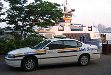 Metro Transit supervisor car on the waterfront in Dartmouth, with the Dartmouth ferry in the background
Metro Transit runs a Community Transit service, allowing residents in some suburban and rural communities access to the regular and express bus system operated by Metro Transit.
There are three Community Transit routes:[6]
- Porters Lake, offering Monday-Saturday service between Portland Hills Terminal in Dartmouth and the communities of East Preston, Lake Echo, Porters Lake and Grand Desert via Portland St, Cole Harbour Rd, Forest Hills Pkwy and Highway #7.
- Beaver Bank, offering weekday service between the new Sackville Terminal and Beaver Bank Villa in Beaver Bank via the Beaver Bank Road.
- Sambro, offering weekday service between South Centre Mall in Spryfield and the Ketch Harbour fire hall Ketch Harbour via the old Sambro road and hwy 349. This route uses the same buses as the Metro X service does.
Cash fare on all three routes is $2.25 (Adult/Student) $1.50 (Children/Senior 5–15). Tickets and transfers from other routes are accepted, Monthly bus passes and U-Passes are accepted. Transfers are issued on request on these routes that allow passengers to continue their travels on other Metro Transit routes.
Access-A-Bus
Metro Transit also provides Access-A-Bus service which is a dial-a-ride service for elderly and handicapped residents in the region. This service was created in 1981, the same year Metro Transit was formed.[7] There are approximately 20 Access-A-Bus vehicles[citation needed].
GoTime
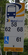 Bus stop sign on Alderney Drive.
GoTime is the name of Metro Transit's automated vehicle locater (AVL) system. The generation system (unveiled over the winter of 2007/2008) uses Global Positioning System (GPS) technology to track buses throughout the system, providing information on location and schedule adherence to the transit control centre. This information is also used to update Metro Transit's real time bus departure system available to the general public.
Concept
Each bus stop sign has a blue 4-digit GoTime number on it. A passenger can dial 480- plus the 4-digit number to hear an automated message telling them exactly when the next bus on each route servicing that stop will depart, based on the information calculated above. Also, GoTime monitors are placed at every transit terminal, and a few major stops, listing each of the routes that service that stop and when the next two buses on those routes will arrive at that stop. This information is continually updated as the central GoTime system recalculates bus departure times, using the data collected from the buses. In addition to this, each bus is equipped with an on board computer which continually updates the driver on exactly how many minutes ahead of or behind schedule they are, to ensure schedule adherence. A web-based component was developed to provide departure times information via the internet in both standard internet and mobile internet formats.
Technical difficulties and limitations
As of 2010 the system’s functionality was limited to just scheduled transit data (as opposed to live transit data) with information displays at terminals malfunctioning on a regular basis.[8] Metro Transit publicly announced the web-based GoTime system in the Winter of 2007–2008 utilizing a pamphlet distributed in busses that had an incorrect URL (http://halifax.ca/metrotransit/gotime) to the service. This component, which can be found at http://halifax.ca/gotime was never correctly or officially released to the public.
History
The new GPS-based system replaces an older system originally designed by the former City of Halifax between 1984 and 1987, one the earliest real-time passenger information and transit management systems in North America.[9] The previous generation system used wheel rotation sensors to calculate the distance traveled from the start of the route, which was then transmitted back to the transit control centre. This data allowed the system to calculate the buses position along its route, as well as exact departure times for each bus stop ahead of it. In addition to wheel sensors, door sensors were used to determine when the bus was at a stop, and a series of electronic transmitters mounted to power poles along each route allowed the system to further calculate the buses position along its route. As with the current-generation system, the previous system also had a call-in system where a user could call the 4-digit GoTime number on each bus stop and hear an automated message telling them when the next two buses on each route servicing that stop would depart, monitors at all terminals displaying real-time departure information, and on board computers displaying information to drivers on how far ahead or behind schedule they are.
The hardware to support the previous-generation GoTime system had been steadily deteriorating over time, as the last major overhaul to the system was completed in 1996. There is reference to funds being allocated in 1998 for a GoTime upgrade,[10] however, it is believed that the companies that were contracted to perform the upgrade, failed to do so when they each went bankrupt. Due to the instability of the system, it is believed that sometime between 2004 and 2005, the "real-time" functionality of the GoTime system was disabled, as phoning the system seemed only to tell the scheduled departure times, not actual departure times; the phone-in component used the words "scheduled to depart in" when real-time data was unavailable, and "will depart in" when the data was available.
Fleet
Current
Manufacturer Model Model Years Fleet Numbers No. Purchased No. Remaining in Service Notes/History GMDD TC40-102N Classic 1986 896 – 910 15 2 Renumbered from 996 – 1010 in 1987. MCI TC40-102N Classic 1987
1988
1989
1990921 – 928
929 – 940
941 – 947
948 – 9528
12
7
51
7
3
5Some of these retired due to lots of New Flyer D40LF's in service. MCI / NovaBus TC60-102N Articulated Classic 1992
1993701 – 707
708 – 7147
75
5In 1993, MCI was taken over by NovaBus in the middle of the 1993 order; as a result, 708 – 710 bear the MCI logo, while 711 – 714 bear the NovaBus logo. NovaBus discontinued the articulated Classic immediately following the fulfillment of this order. NovaBus TC40-102N Classic 1994
1995
1996953 – 966
967 – 974
975 – 98514
8
1113
8
11975 & 976 were test buses running on propane. The fuel provided less power than expected, and the engines were converted to diesel. NovaBus Nova LFS 1999
2000986 – 996
997 – 100011
411
4These were originally designated for use on low floor routes, but now are also commonly used on routes that are not designated as accessible, because the ramps do not function, and the buses do not kneel as they are supposed to. New Flyer Industries D30LF 1999 505 – 507 3 3 These buses operate on the Beaver Bank and Porters Lake Community Transit service. New Flyer Industries D40LF 2002
2004
2005
2005
2006
2007
2008
20091001 – 1032
1033 – 1060
1061 – 1082
600 – 619
1083 – 1107
1108 – 1130
1131 – 1153
1154 – 115932
28
22
20
25
23
23
632
28
22
20
25
23
23
6600 – 619 are branded for use on the MetroLink service, but are occasionally pressed into service on conventional routes.
600 – 619, 1083 – 1159 have air conditioning.New Flyer Industries DE60LFR Articulated 2009 715 – 716 2 2 715 – 716 are both hybrids. Glaval Bus Titan 2009 516 – 525 10 10 516 – 525 are branded for, and usually operate on, the MetroX and Sambro Community Transit service, but also occasionally provide service on conventional routes. NovaBus Nova LFS Articulated 2010
2010717 – 731
732 – 74115
1015
10717 – 731 were put into service on August 30, 2010.
732 – 741 were delivered December 2010 and entered service in February 2011 during the Canada Winter Games.Past
Manufacturer Model Model Years Fleet Numbers No. Purchased Notes/History GMDD T6H-5305 New Look 1969
1971801 – 819
820 – 82319
4Prior to 1981, these buses were owned by Halifax Transit Corporation GMDD T6H-4521 New Look 1969
1971401 – 455
133 – 13555
3Prior to 1981, 401 – 455 were owned by Halifax Transit Corp; 133 – 135 were owned by Dartmouth Transit Service GMDD TDH-3301 New Look 1971 130 – 131 2 Prior to 1981, these buses were owned by Dartmouth Transit Service GMDD TDH-3302N New Look 1973 137 1 Prior to 1981, this bus was owned by Dartmouth Transit Service GMDD T6H-4523N New Look 1973
1975
1976
1977138 – 139
143 – 144
145 – 147
148 – 1502
2
3
3Prior to 1981, these buses were owned by Dartmouth Transit Service GMDD T6H-5307N New Look 1981/82
1975
1978
1982510 – 515
824 – 835
836 – 856
857 – 8696
12
21
13Prior to 1981, 824 – 856 were owned by Halifax Transit Corp; 857 – 869 were bought after HTC and DTS merged into Metro Transit; 510 – 515 were purchased from BC Transit. 512 had an electronic sign. GMDD TC40-102N Classic 1983
1985
1987870 – 881
882 – 895
911 – 92012
14
10The 1983 buses originally had rollsigns, although some have since been converted to electronic destination signs. Orion Bus Industries 01.501 (Orion I) 1981 501 – 504 4 Purchased from the Toronto Transit Commission in 1990.
501, 502 & 504 were sold to Kings Transit, Nova ScotiaOrion Bus Industries 01.506 (Orion I) 1985 308 1 Purchased from the Pictou County Regional Transit Authority in 1996.
Sold to Kings Transit, Nova ScotiaSaab-Scania CN112A 1984 201 – 212 12 Assembled from 'completely knocked-down' kits by Tri-Star Industries of Yarmouth, NS; purchase subsidised by NS government in an attempt to create a provincial bus-building industry Ferries
 Halifax III
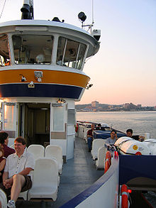 Close-up of HRM ferry
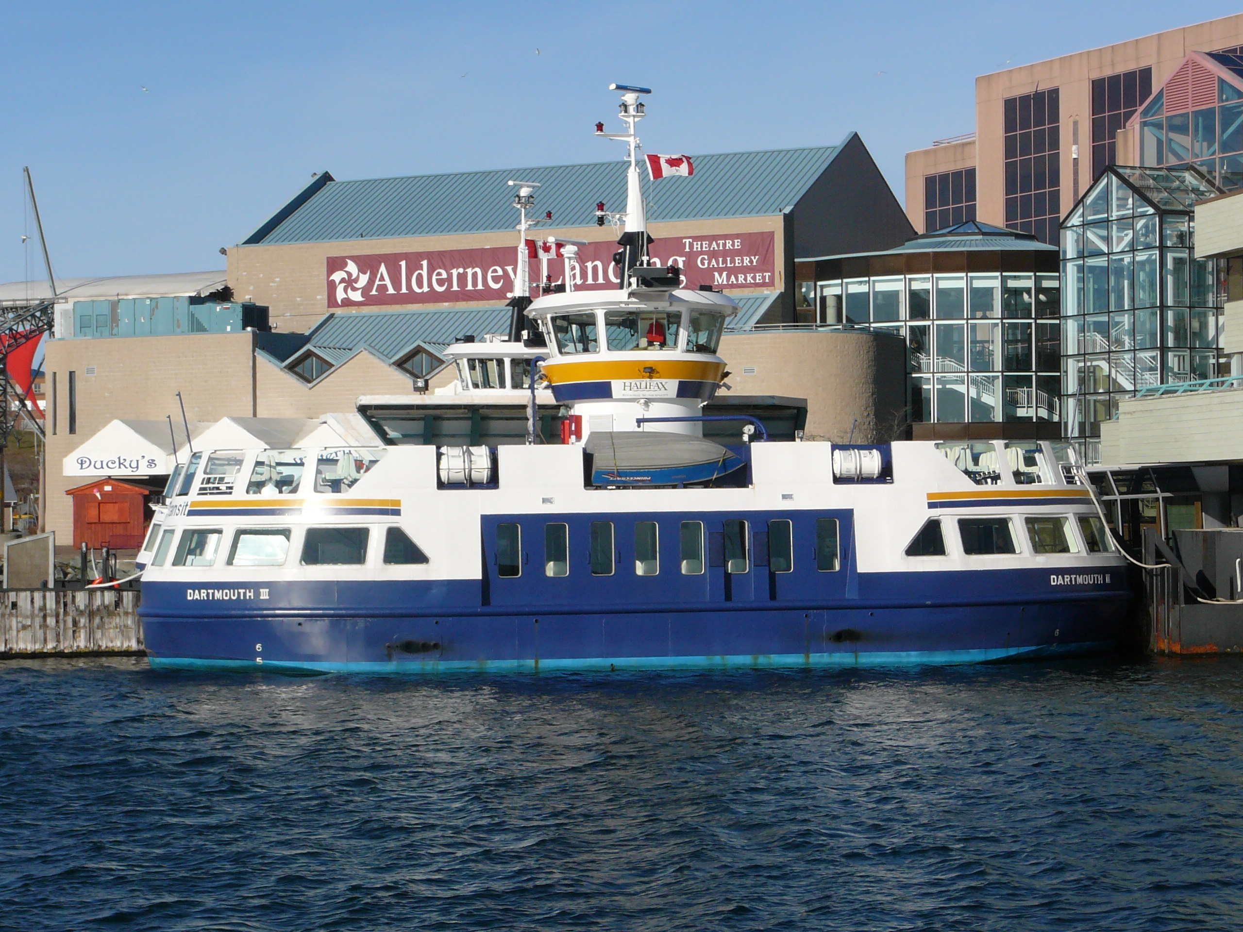
 Dartmouth III
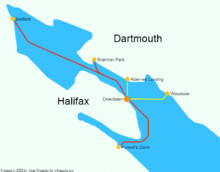 A map of Metro Transit ferry routes, both existing and possible new ones. (Note: Possible route to Eastern Passage is not included)
Current service
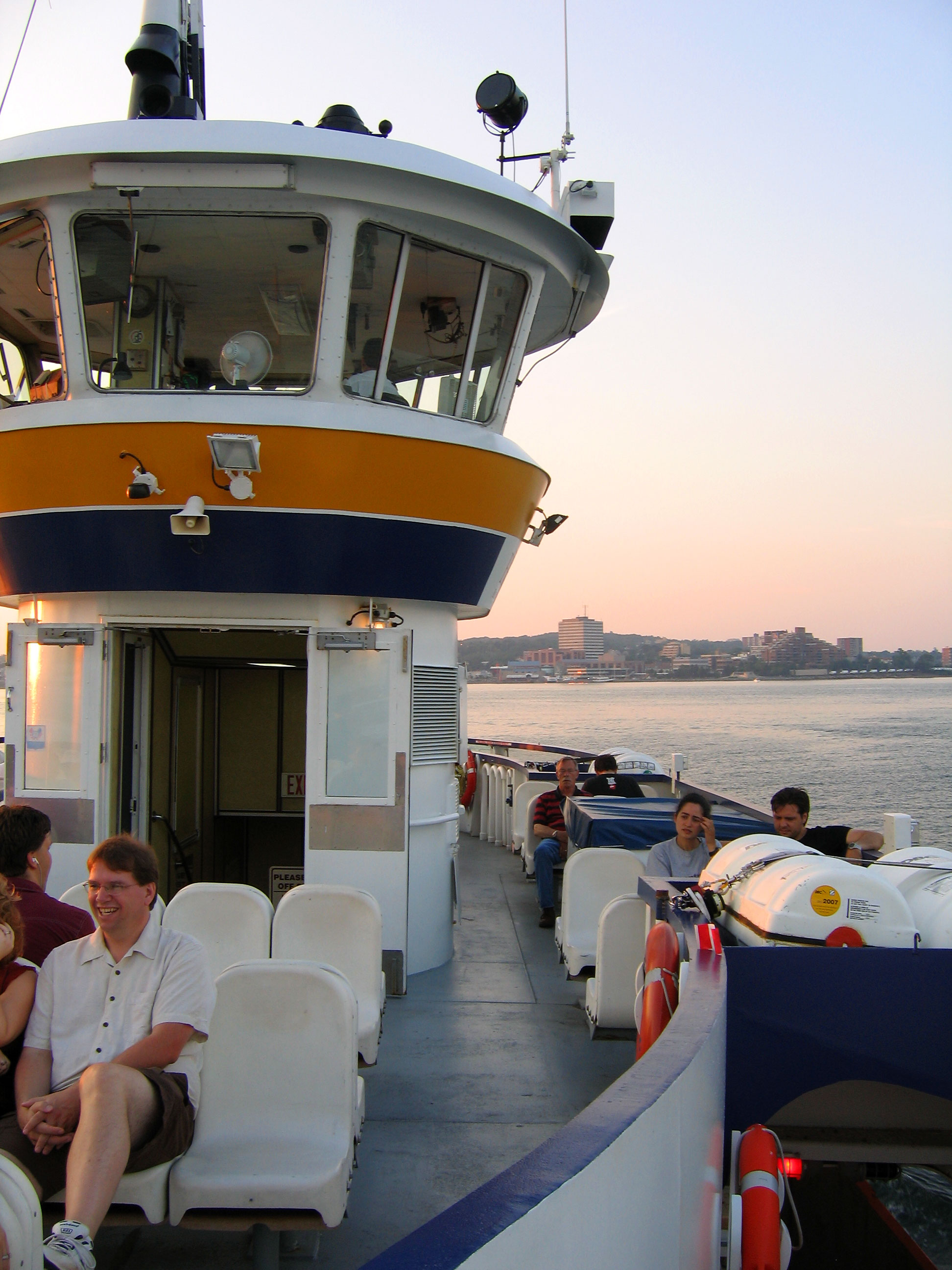
Metro Transit also provides two passenger ferry routes, one connecting downtown Halifax with Alderney Landing in Dartmouth (which operates daily using two vessels) and the other connecting downtown Halifax with Woodside (Monday through Friday only using one vessel). The ferry services are integrated with the bus services; the fares are identical, and transfers are accepted between the two systems. The harbour ferries are utilised by over 3,000 commuters daily[11] Each ferry carries up to 398 passengers. The characters of Phillip and Phillmore, the ferry twins from the children's TV show, Theodore Tugboat are modelled after these vessels.
Proposed high speed service
In recent years, following unfulfilled plans to implement commuter rail, the municipality has begun to plan several new high speed ferry routes on Halifax Harbour, including service to Purcell's Cove, Bedford, Eastern Passage and Shannon Park. These routes would be served by wave piercing catamarans capable of speeds of approximately 40 knots. Details have not been finalized, however it is likely that the downtown Halifax terminal would act as a hub, with all routes radiating outward. Studies and trials have been undertaken for a Bedford-Halifax route, which will likely be the first high speed service.
Fleet
Current
There are three ferries in operation:
- Dartmouth III – Built in 1979 in Pictou, Nova Scotia.
- Halifax III – Built in 1979 in Pictou.
- Woodside I – Built in 1986 in Pictou.
All three ferries are double-ended side-loading, and use two 230 hp Caterpillar model 3306 engines, each driving a model 12E/75 Voith-Schneider propeller.
Past
The Dartmouth to Halifax ferry service dates from 1752.[12] Following is a list of earlier ferries as far as is known.
- Dartmouth II – Built in 1956 in Lunenburg, Nova Scotia, retired in 1979.[13]
- Halifax II – Built in 1956 in Lunenburg, retired in 1979.[13]
- Scotian – Built in 1946 in Pictou, Nova Scotia, retired in 1955.[13]
- Governor Cornwallis – Built in 1941 in Dartmouth, Nova Scotia, retired in 1944 (destroyed by fire).[13]
- Dartmouth – Built in 1934 in Lauzon, Quebec, retired in 1957.[13]
- Halifax – Built in 1911, retired in 1956.[13]
- Chebucto – Built in 1906, retired in 1951.[13]
- Annex 2 – Built in 1878 in New Baltimore, New York, retired in 1909 (destroyed by fire).[13]
- Arcadia – Built in 1884 in Yarmouth, Nova Scotia, retired in 1891.[13]
- Dartmouth – Built in 1888 in Yarmouth, retired in 1935.[13]
- Chebucto – Built in 1878 in Dartmouth, retired in 1892.[13]
- Mic Mac – Built in 1878 in Dartmouth, retired in 1901.[13]
- Boxer – Built in 1838 in Dartmouth, retired in 1864.[13]
- Sir C. Ogle – Built in 1830 in Dartmouth, retired in 1894.[13]
- Sherbrooke – Built in 1816 in Dartmouth, retired in 1830.[13]
See also
References
- ^ a b Halifax Regional Municipality Transportation and Public Works – 2008/09 Business Plans and Budget
- ^ Metro Transit, U-Pass
- ^ Metro Transit, Tickets and Passes
- ^ Metro Transit, 2008 News Archive
- ^ Metro Transit, Metro Express page (with planning documents)
- ^ Metro Transit, Community Transit
- ^ Metro Transit, Access-a-bus
- ^ "How to Fix the City Scorecard"
- ^ Transport Canada,"GoTime: Real-time passenger information and transit management" Case study, July, 2007
- ^ HRM, Halifax Regional Council Minutes, June 30, 1998
- ^ Metro Transit, Dartmouth-Halifax Harbour Ferries
- ^ Metro Transit, Harbour Ferries
- ^ a b c d e f g h i j k l m n o Payzant, J. & Lewis, J (1979): Like A Weaver's Shuttle: A History of the Halifax-Dartmouth Ferries. Nimbus Publishing.
External links
- Metro Transit's official website
- Complete route map for Halifax-Dartmouth area.
- Complete route map for Bedford-Sackville area.
- Schedules, maps for individual routes, riders guide.
- hbus.ca Community-based trip-planning service for Halifax
Halifax Regional Municipality Government Services and agencies Articles of interest History • Metropolitan Halifax • Geography • Halifax Harbour • Education • Economy • Culture • Sports • Media • Transportation • Buildings and infrastructure • Communities • Halifax Explosion • Capital District • Port Authority • School Board • Halifax Harbour SolutionsCommunity areas Bedford • Chebucto Peninsula • Cole Harbour & Westphal • Cow Bay & Eastern Passage • Dartmouth • Eastern Shore East • Eastern Shore West • Mainland Halifax • Halifax Peninsula • Hammonds Plains, Upper Sackville & Beaver Bank • Lake Echo & Porters Lake • Lawrencetown • Musquodoboit Valley & Dutch Settlement • Preston & Cherrybrook • Prospect • St. Margaret's Bay • Timberlea, Lakeside, BeechvilleCoordinates: 44°41′34″N 63°35′4.4″W / 44.69278°N 63.584556°W
Categories:- Transportation in the Halifax Regional Municipality
- Transit agencies in Nova Scotia
- Bus transport in Nova Scotia
- Ferry companies of Nova Scotia
- Paratransit services in Canada
- Intermodal transport authorities in Canada


Wikimedia Foundation. 2010.