- Geography of the Halifax Regional Municipality
-
The Halifax Regional Municipality (HRM) in Nova Scotia, Canada has a widely varied geography.
Contents
Physical geography
HRM has an area of approximately 5,850 km², comparably larger than Prince Edward Island, and is approximately 165 km in length between its eastern and western-most extremities. HRM's shoreline "as the crow flies" is approximately 150 km in length, while its northern boundary is usually between 50–60 km inland. The coast, which is mostly rock with small isolated sand beaches in sheltered bays, is heavily indented by numerous inlets the largest of which are St. Margarets Bay, Halifax Harbour, Cole Harbour, Musquodoboit Harbour, Jeddore Harbour, Ship Harbour and Sheet Harbour. Given this fact, it takes approximately 3 hours to drive along the shore from Hubbards, located in the southwestern end of HRM, to Ecum Secum, 195 km (121 mi) away at the southeastern end.
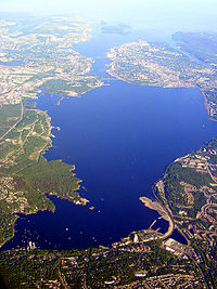
The Chebucto Peninsula, created by the indentations of St. Margarets Bay and Halifax Harbour (including the Bedford Basin), is a defining feature for the shape of the coastline at the western end of HRM, from which the Halifax Peninsula forms a sub-peninsula.
Despite the size of its landmass, the population of the municipality is heavily concentrated, with rural communities located along the Eastern Shore and South Shore or in the Musquodoboit Valley. The majority of residents are concentrated in the urban core surrounding Halifax Harbour/Bedford Basin and extending up the Sackville River valley and northeast of the harbour along the Highway 102 corridor.
Sable Island is part of HRM, despite being located 180 km (110 mi) offshore of neighbouring Guysborough County and approximately 300 km from HRM's urban core. HRM's boundary includes all of the former Halifax County, except for several First Nation reserves.
HRM's topography is quite varied, ranging from rocky shorelines to sandy beaches on the coast, to landscapes shaped by glaciation including exposed bedrock, numerous freshwater lakes, medium-sized rivers and streams, drumlins and low hills. The fertile valley along the Musquodoboit River in the northeastern part of HRM is the only agricultural district of note in the municipality. Aside from the settled communities and the urban area surrounding Halifax Harbour, the rest of the municipality's landscape mostly supports a dense combination of mixed Acadian or coniferous forests.
HRM's urban area is built on a series of hills and plateaus surrounding Halifax Harbour; the central part of the Halifax lies on a peninsula extending from the western side of the harbour and dominated by the drumlin which supported the Citadel Hill defensive works. The Dartmouth was clustered on the eastern side of the harbour directly opposite the Halifax peninsula, its defining geographic feature being a series of glacial lakes. Suburban growth around both cities included many existing mining (east of Dartmouth and the Shubenacadie Valley) and farming (in the Mosquito Valley and northwest of Halifax) and fishing (along the shores of the harbours and the Atlantic coast south of both former cities) communities.
Climate
Halifax Climate chart (explanation) J F M A M J J A S O N D 1510−91140−81344−412181119146108191110623149823151071911135136154811603−5Average max. and min. temperatures in °C Precipitation totals in mm Source: Environment Canada [1] Imperial conversion J F M A M J J A S O N D 5.932174.532175.338244.847334.757424.367514.273583.973594.266535.356436.146346.33723Average max. and min. temperatures in °F Precipitation totals in inches Halifax is marked by a humid continental climate (Köppen Dfb), but the area climate is heavily influenced by water temperatures in the adjacent Atlantic Ocean. Numerous local microclimates make weather somewhat unpredictable but the region is generally milder than inland areas having a continental climate (e.g. central Canada); HRM air temperatures average between -5°C (23°F) and 25°C (77°F).
Snow falls and melts alternately mainly from November through April, for a seasonal total of 152 centimetres (60 in).[1] Some, but usually very little, snow falls in May and October.[1] Halifax usually experiences several strong winter storms. In February 2004 a record of 95 centimetres (37 in) of snow fell in one such storm. The storm was nicknamed "White Juan", after the recent Hurricane Juan. Spring is cool and foggy, early autumn is often sunny and warm, and summer can range from hot and dry to cool and rainy. Hurricanes are fairly uncommon but do occur occasionally. There can be considerable variations between the weather near the Atlantic Ocean and the weather even several kilometres inland. This is partly caused by the effect of the Labrador Current, which transfers cold water from the Arctic along Nova Scotia's Atlantic coast in the spring and summer, while the Gulf Stream brings warmer water from the Gulf of Mexico along the coast during the fall and winter.
Precipitation stands at nearly 1,510 millimetres (59.4 in) annually, and is somewhat heavy year-round, though summer is drier.
The Halifax Regional Municipality is home to 6 weather stations operated by the Meteorological Service of Canada:
- Halifax International Airport
- Buoy 44258 Halifax Harbour[1]
- CFB Shearwater
- McNabs Island
- Sable Island
- Beaver Island
- Malay Falls
Climate data for Halifax, Nova Scotia (Halifax Citadel, 1971−2000) Month Jan Feb Mar Apr May Jun Jul Aug Sep Oct Nov Dec Year Record high °C (°F) 14.0
(57.2)16.0
(60.8)23.5
(74.3)26.1
(79.0)33.3
(91.9)34.0
(93.2)33.0
(91.4)33.9
(93.0)32.2
(90.0)24.0
(75.2)20.0
(68.0)16.7
(62.1)34.0
(93.2)Average high °C (°F) −0.2
(31.6)−0.1
(31.8)3.5
(38.3)8.4
(47.1)14.1
(57.4)19.4
(66.9)22.9
(73.2)23.0
(73.4)19.0
(66.2)13.1
(55.6)7.9
(46.2)2.6
(36.7)11.2 Average low °C (°F) −8.6
(16.5)−8.1
(17.4)−4.2
(24.4)0.8
(33.4)5.5
(41.9)10.5
(50.9)14.2
(57.6)14.8
(58.6)11.4
(52.5)5.9
(42.6)1.2
(34.2)−5.1
(22.8)3.2 Record low °C (°F) −26.1
(−15)−25
(−13)−21
(−5.8)−12
(10)−2.8
(27.0)1.7
(35.1)7.2
(45.0)6.1
(43.0)1.0
(33.8)−5
(23)−13.9
(7.0)−23.3
(−9.9)−26.1
(−15)Wind chill −40.4 −41.1 −33.9 −24.4 −10.9 −5.6 3.7 0.7 −3.6 −10.1 −23.9 −35.6 −41.1 Precipitation mm (inches) 150.7
(5.933)113.8
(4.48)134.4
(5.291)121.1
(4.768)119.4
(4.701)108.0
(4.252)105.9
(4.169)98.3
(3.87)107.1
(4.217)135.4
(5.331)153.7
(6.051)160.2
(6.307)1,508.0
(59.37)Rainfall mm (inches) 112.3
(4.421)76.2
(3)106.0
(4.173)111.3
(4.382)118.1
(4.65)108.0
(4.252)105.9
(4.169)98.3
(3.87)107.1
(4.217)134.4
(5.291)146.8
(5.78)131.7
(5.185)1,356.1
(53.39)Snowfall cm (inches) 38.4
(15.12)37.7
(14.84)28.4
(11.18)9.8
(3.86)1.2
(0.47)0
(0)0
(0)0
(0)0
(0)1.0
(0.39)6.9
(2.72)28.5
(11.22)151.9
(59.8)Avg. precipitation days (≥ 0.2 mm) 13.1 10.5 12.5 14.3 14.4 12.6 11.0 10.3 10.9 13.5 14.3 14.2 151.6 Avg. rainy days (≥ 0.2 mm) 8.3 5.8 9.6 12.9 14.3 12.6 11.0 10.3 10.9 13.3 13.6 10.8 133.4 Avg. snowy days (≥ 0.2 cm) 6.1 5.6 4.1 1.9 .2 0 0 0 0 .2 1.1 4.9 24.1 Source: Environment Canada [1] References
- ^ a b c d "Canadian Climate Normals 1971−2000: Canada's National Climate Archive". http://www.climate.weatheroffice.ec.gc.ca/climate_normals/results_e.html?Province=ALL&StationName=Halifax&SearchType=BeginsWith&LocateBy=Province&Proximity=25&ProximityFrom=City&StationNumber=&IDType=MSC&CityName=&ParkName=&LatitudeDegrees=&LatitudeMinutes=&LongitudeDegrees=&LongitudeMinutes=&NormalsClass=A&SelNormals=&StnId=6357&. Retrieved 2008−07−16.
Halifax Regional Municipality Government Services and agencies Articles of interest History • Metropolitan Halifax • Geography • Halifax Harbour • Education • Economy • Culture • Sports • Media • Transportation • Buildings and infrastructure • Communities • Halifax Explosion • Capital District • Port Authority • School Board • Halifax Harbour SolutionsCommunity areas Bedford • Chebucto Peninsula • Cole Harbour & Westphal • Cow Bay & Eastern Passage • Dartmouth • Eastern Shore East • Eastern Shore West • Mainland Halifax • Halifax Peninsula • Hammonds Plains, Upper Sackville & Beaver Bank • Lake Echo & Porters Lake • Lawrencetown • Musquodoboit Valley & Dutch Settlement • Preston & Cherrybrook • Prospect • St. Margaret's Bay • Timberlea, Lakeside, BeechvilleCategories:

Wikimedia Foundation. 2010.