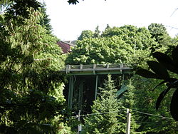
- North Queen Anne Drive Bridge
-
North Queen Anne Drive Bridge 
Crosses Wolf Creek Design deck arch Material steel and concrete Total length 238-foot (73 m) Opened 1936 Heritage status Seattle city landmark The North Queen Anne Drive Bridge is a deck arch bridge that spans Seattle's Wolf Creek. The 238-foot (73 m) long steel and concrete structure was built in 1936 to replace the previous wood-constructed crossing. It serves as a connection between the Queen Anne neighborhood and the George Washington Memorial Bridge that carries State Route 99. The arch is unusually high and uses a minimal amount of supporting members. It was designated a city landmark on December 28, 1981, because of its unique engineering style.[1][2]
An expansion joint suffered cracking and spalling during the 2001 Nisqually earthquake.[3] The bridge has been retrofitted to make it more earthquake-resistant.[4]
References
- ^ Wilma, David (April 17, 2001). "Seattle Landmarks: Queen Anne Drive Bridge (1936)". HistoryLink.org Online Encyclopedia of Washington State History. http://www.historylink.org/index.cfm?DisplayPage=output.cfm&file_id=3209. Retrieved April 4, 2011.
- ^ Crowley, Walt; Dorpat, Paul (1998). National Trust Guide, Seattle: America's Guide for Architecture and History Travelers. Preservation Press, J. Wiley & Sons. p. 251. ISBN 9780471180449.
- ^ McDonough, Peter W. (2002). The Nisqually, Washington, Earthquake of February 28, 2001: Lifeline Performance. American Society of Civil Engineers. pp. 76. ISBN 9780784406151.
- ^ Lange, Larry (August 2, 2007). "Steel-truss bridges get emergency look". Seattle Post-Intelligencer. http://www.seattlepi.com/default/article/Steel-truss-bridges-get-emergency-look-1245626.php. Retrieved April 4, 2011.
Bridges and tunnels in and around Seattle Road bridges: Alaskan Way Viaduct | Ballard Bridge | Cowen Park Bridge | East Channel Bridge | Evergreen Point Floating Bridge | First Avenue South Bridge | Fremont Bridge | George Washington Memorial Bridge (Aurora Bridge) | Homer M. Hadley Memorial Bridge (Third Lake Washington Floating Bridge) | Jose Rizal Bridge | Lacey V. Murrow Memorial Bridge (I-90 Floating Bridge) | Magnolia Bridge | Montlake Bridge | North Queen Anne Drive Bridge | Schmitz Park Bridge | Ship Canal Bridge | South Park Bridge | Spokane Street Bridge | 20th Avenue NE Bridge | University Bridge | West Seattle BridgeRail bridges/trestles: Tunnels: Battery Street Tunnel | Great Northern Tunnel | Mercer Island Lid | Downtown Seattle Transit Tunnel | Mount Baker Tunnel | Convention Center-Freeway Park Lid | Beacon Hill TunnelU.S. National Register of Historic Places Topics Lists by states Alabama • Alaska • Arizona • Arkansas • California • Colorado • Connecticut • Delaware • Florida • Georgia • Hawaii • Idaho • Illinois • Indiana • Iowa • Kansas • Kentucky • Louisiana • Maine • Maryland • Massachusetts • Michigan • Minnesota • Mississippi • Missouri • Montana • Nebraska • Nevada • New Hampshire • New Jersey • New Mexico • New York • North Carolina • North Dakota • Ohio • Oklahoma • Oregon • Pennsylvania • Rhode Island • South Carolina • South Dakota • Tennessee • Texas • Utah • Vermont • Virginia • Washington • West Virginia • Wisconsin • WyomingLists by territories Lists by associated states Other  Category:National Register of Historic Places •
  Portal:National Register of Historic PlacesCategories:
- Bridges in Seattle, Washington
- Bridges completed in 1936
- Landmarks in Seattle, Washington
- Road bridges in Washington (state)
- Bridge (structure) stubs
Wikimedia Foundation. 2010.
