- Medicine Wheel/Medicine Mountain National Historic Landmark
-
Medicine Wheel/Medicine Mountain National Historic Landmark
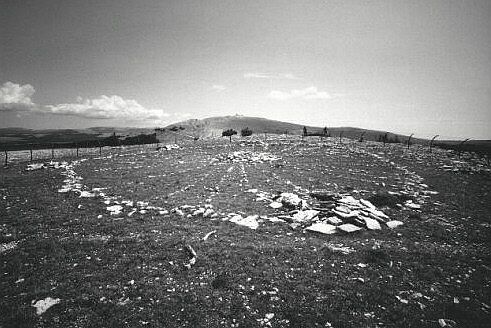
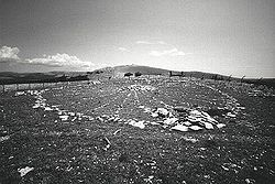 The Medicine Wheel in Big Horn County, Wyoming, USA
Nearest city: Kane, Wyoming Governing body: Forest Service NRHP Reference#: 69000184 Significant dates Added to NRHP: April 16, 1969[1] Designated NATIONAL HISTORIC LANDMARK: August 29, 1970[2] 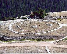 The Medicine Wheel in Bighorn National Forest, Wyoming
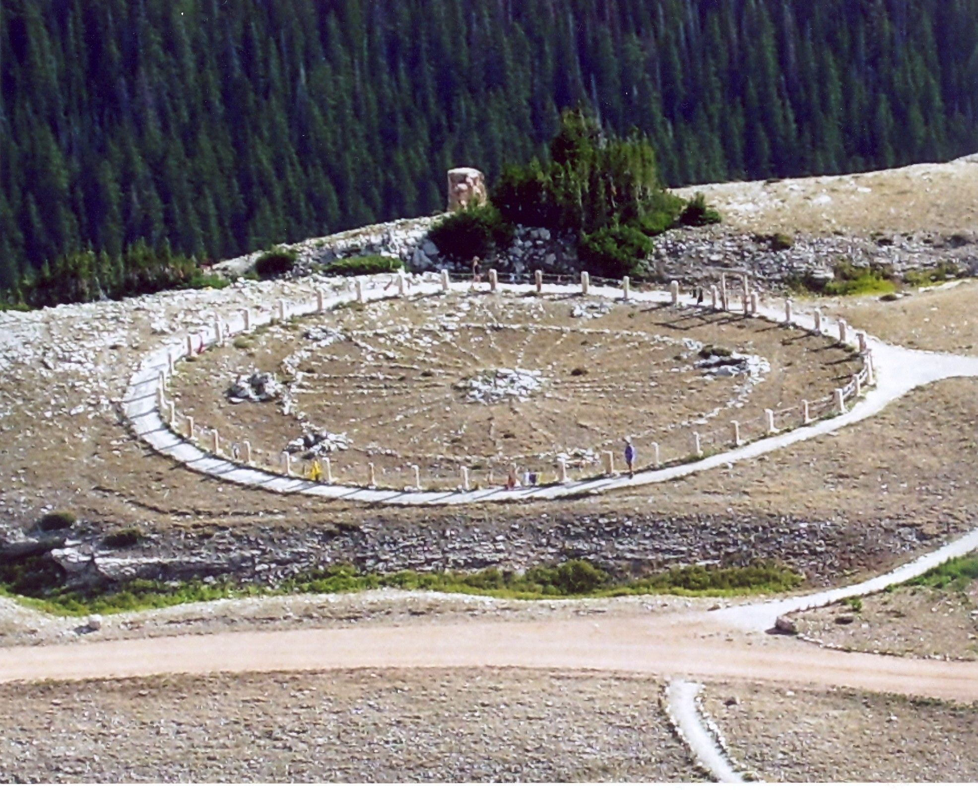
The Medicine Wheel/Medicine Mountain National Historic Landmark (formerly known as the Bighorn Medicine Wheel) is a medicine wheel located in the Big Horn Mountains of the U.S. state of Wyoming.
For centuries, the Bighorn Medicine Wheel has been used by Crow youth for fasting and vision quests. Native Americans also go to Bighorn to offer thanks for the creation that sustains them, placing a buffalo skull on the center cairn as a prayer offering. Prayers are offering here for healing, and atonement is made for harm done to others and to Mother Earth.[3]
The structure is located at an altitude of nearly 10,000 feet (3,000 m), near the summit of Medicine Mountain. It is a precolumbian structure, built from roughly loaf-sized stones gathered from the surrounding area. The structure consists of a circular rim, 25 yards (23 m) in diameter, 28 spokes extending from the rim to the center, and a series of seven cairns. Cairn O is at the center of the structure and is almost 10 feet (3.0 m) in diameter. Cairns A - F are at or near the rim, and are considerably smaller. Astronomer John Eddy investigated this structure in 1972 and made a number of important discoveries, publishing his findings in Astronomical Alignment of the Big Horn Medicine Wheel, Science 184 (1974): 1031-43. He found that cairns E and O were aligned in the direction of summer solstice sunrise, using cairn E for a backsight and cairn O as a foresight, and that cairns C and O were aligned in the direction of summer solstice sunset, using C as a backsight and O as a foresight. Further he found that cairn pairs FO, FA, and FB correspond to the rising points of the stars Sirius, Aldebaran, and Rigel, respectively. Observing the first yearly heliacal rising of these stars would have been an effective tool at predicting how many days remained before the summer solstice, as the first heliacal rise of a star occurs on the same date. Rising positions of stars change very slowly over the centuries, due to the Earth's precession, so the directions of these cairn pairs can be used to project at what date they aligned best with the rising points of these stars. The FA Aldebaran alignment would have worked best between AD 1200 and AD 1700. Further, precession changes the date of first helical rise: Although today the first heliacal rise of Aldebaran is a few days after the summer solstice, between AD 1200 and 1700, the first heliacal rise of Aldebaran would have been just before the summer solstice, allowing an observer to predict the coming of this event. Astronomer Jack Robinson has further proposed that cairn pair FD was used to observe the rising of the star Fomalhaut, which would have lined up with its rising point between AD 1050 and AD 1450, when Fomalhaut had its first heliacal rise roughly a month before the summer solstice. A carbon date for the Bighorn Medicine Wheel comes from a piece of wood found in cairn F, corresponding to an age of no more than 220 years, roughly in the middle of the 18th century. However, this date can only be considered as a minimum age, as the wood may have become lodged in the cairn after construction.
The site was declared a National Historic Landmark in 1970,[2] and renamed as the Medicine Wheel/Medicine Mountain National Historic Landmark in 2011.[4]
References
- ^ "National Register Information System". National Register of Historic Places. National Park Service. 2008-04-15. http://nrhp.focus.nps.gov/natreg/docs/All_Data.html.
- ^ a b "Medicine Wheel". National Historic Landmark summary listing. National Park Service. http://tps.cr.nps.gov/nhl/detail.cfm?ResourceId=841&ResourceType=Site. Retrieved 2011-07-16.
- ^ "Bighorn Medicine Wheel". Sacred Destinations. http://www.sacred-destinations.com/usa/bighorn-medicine-wheel. Retrieved 2011-07-16.
- ^ "Medicine Wheel landmark gets new boundary". Lovell Chronicle (Lovell, Wyoming: Lovellchronicle.com). 2011-07-07. http://www.lovellchronicle.com/2011/07/medicine-wheel-landmark-gets-new-boundary/. Retrieved 2011-07-16.
External links
- Medicine Wheel National Historic Landmark at the Wyoming State Historic Preservation Office
- A Report on the Medicine Wheel
- Medicine Wheel/Medicine Mountain NHL District
National Register of Historic Places in Big Horn County, Wyoming National Historic Landmark 
Historic districts Big Horn Academy Historic District | Black Mountain Archeological District (48BH900/902/1064/106 7/1126/1127/1128/1129) | Paint Rock Canyon Archeological Landscape District
Historic properties Bad Pass Trail | Basin Republican-Rustler Printing Building | Bear Creek Ranch Medicine Wheel (48BH48) | Bridger Immigrant Road-Dry Creek Crossing | EJE Bridge over Shell Creek | EJP County Line Bridge | EJZ Bridge over Shoshone River | Hanson Site | Hyart Theater | Lower Shell School House | M L Ranch | Medicine Lodge Creek Site | Rairden Bridge | US Post Office-Basin Main | US Post Office-Greybull Main
See also: National Register of Historic Places listings in Big Horn County, Wyoming and List of National Historic Landmarks in Wyoming U.S. National Register of Historic Places Topics Lists by states Alabama • Alaska • Arizona • Arkansas • California • Colorado • Connecticut • Delaware • Florida • Georgia • Hawaii • Idaho • Illinois • Indiana • Iowa • Kansas • Kentucky • Louisiana • Maine • Maryland • Massachusetts • Michigan • Minnesota • Mississippi • Missouri • Montana • Nebraska • Nevada • New Hampshire • New Jersey • New Mexico • New York • North Carolina • North Dakota • Ohio • Oklahoma • Oregon • Pennsylvania • Rhode Island • South Carolina • South Dakota • Tennessee • Texas • Utah • Vermont • Virginia • Washington • West Virginia • Wisconsin • WyomingLists by territories Lists by associated states Other  Category:National Register of Historic Places •
  Portal:National Register of Historic PlacesCategories:
- National Historic Landmarks in Wyoming
- Buildings and structures in Big Horn County, Wyoming
- Megalithic monuments
- Religious places of the indigenous peoples of North America
- Properties of religious function on the National Register of Historic Places in Wyoming
Wikimedia Foundation. 2010.