- Maple Street Covered Bridge
-
Maple Street Covered Bridge 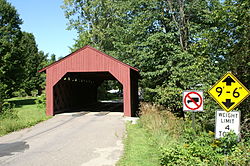
Carries Automobile Crosses Mill Brook Locale Fairfax, Vermont Maintained by Town of Fairfax ID number VT-06-02 Design Covered, Town lattice Material Wood Total length 56.8 ft (17.3 m) Width 17.3 ft (5.3 m) Number of spans 1 Load limit 4 tons Vertical clearance 9.5 ft (2.9 m) Constructed by Kingsbury and Stone Construction end 1865

Coordinates: 44°40′06″N 73°00′27″W / 44.66833°N 73.0075°WCoordinates: 44°40′06″N 73°00′27″W / 44.66833°N 73.0075°W NRHP Reference#: 74000215 Added to NRHP: November 5, 1974[1] The Maple Street Covered Bridge, also called the Lower Covered Bridge,[2] is a covered bridge that crosses Mill Brook off State Route 104 in Fairfax, Vermont. It was listed on the National Register of Historic Places in 1974.[1]
The bridge is of Town lattice design, built by Kingsbury and Stone.
Recent history
A major renovation was conducted in 1990-1991 by Jan Lewandoski. Debate is conducted to this day as to whether the bridge is now "backwards". When it was washed off its foundations by the Flood of 1927 it is unknown whether the bridge was put back on in the same direction as it was originally. Some say the eastern portal now faces west, and vice-versa.[3]
References
- ^ a b "National Register Information System". National Register of Historic Places. National Park Service. no date specified. http://nrhp.focus.nps.gov/natreg/docs/All_Data.html.
- ^ U.S. Geological Survey Geographic Names Information System: Lower Covered Bridge
- ^ Barna, Ed. Covered Bridges of Vermont. The Countryman Press, 1996. ISBN 0881503738
U.S. National Register of Historic Places Topics Lists by states Alabama • Alaska • Arizona • Arkansas • California • Colorado • Connecticut • Delaware • Florida • Georgia • Hawaii • Idaho • Illinois • Indiana • Iowa • Kansas • Kentucky • Louisiana • Maine • Maryland • Massachusetts • Michigan • Minnesota • Mississippi • Missouri • Montana • Nebraska • Nevada • New Hampshire • New Jersey • New Mexico • New York • North Carolina • North Dakota • Ohio • Oklahoma • Oregon • Pennsylvania • Rhode Island • South Carolina • South Dakota • Tennessee • Texas • Utah • Vermont • Virginia • Washington • West Virginia • Wisconsin • WyomingLists by territories Lists by associated states Other Categories:- Fairfax, Vermont
- Bridges completed in 1865
- Bridges on the National Register of Historic Places in Vermont
- Covered bridges in Vermont
- Truss bridges
- Wooden bridges in the United States
- Buildings and structures in Franklin County, Vermont
- Transportation in Franklin County, Vermont
- Visitor attractions in Franklin County, Vermont
- Road bridges in Vermont
- Vermont Registered Historic Places building and structure stubs


Wikimedia Foundation. 2010.