- Dry Fork Plantation
-
Dry Fork Plantation
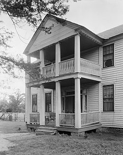 Front portico of Dry Fork in 1939

Nearest city: Coy, Alabama Coordinates: 31°54′6″N 87°21′38″W / 31.90167°N 87.36056°WCoordinates: 31°54′6″N 87°21′38″W / 31.90167°N 87.36056°W Built: 1834 Architect: Hezekiah; Tait, James, et al. Architectural style: Early Republic Governing body: Private NRHP Reference#: 99000250[1] Added to NRHP: February 26, 1999 Dry Fork Plantation is a historic plantation house in Coy, Alabama. The two-story wood-frame house was built between 1832 and 1834 in a vernacular interpretation of Federal style architecture.[1] It was built for James Asbury Tait by two slaves, Hezekiah and Elijah. The floor plan is centered on a hall that separates four rooms, two on each side, on both floors. Tait recorded in his daybook that the house required 25,000 board feet (59 m3) of lumber, the roof was covered with 6,000 wooden shingles, and the chimneys and foundation required 12,000 bricks, made from clay on the plantation. Dry Fork is one of the oldest houses still standing in Wilcox County and remains in the Tait family.[2] It was added to the National Register of Historic Places on February 26, 1999.[1]
References
- ^ a b c "National Register Information System". National Register of Historic Places. National Park Service. 2008-04-15. http://nrhp.focus.nps.gov/natreg/docs/All_Data.html.
- ^ "Dry Fork". Wilcox Area Chamber of Commerce. http://www.wilcoxareachamber.org/history/dryfork.htm. Retrieved 2008-10-14.
National Register of Historic Places in Wilcox County, Alabama Historic districts William King Beck House | Furman Historic District | Oak Hill Historic District | Pine Apple Historic District | Snow Hill Normal and Industrial Institute | Wilcox County Courthouse Historic District

Other properties Ackerville Baptist Church of Christ | Tristram Bethea House | Dry Fork Plantation | Hawthorne House | Liberty Hall | Liddell Archeological Site | Prairie Mission | Tait-Ervin House | Wilcox Female Institute
U.S. National Register of Historic Places Topics Lists by states Alabama • Alaska • Arizona • Arkansas • California • Colorado • Connecticut • Delaware • Florida • Georgia • Hawaii • Idaho • Illinois • Indiana • Iowa • Kansas • Kentucky • Louisiana • Maine • Maryland • Massachusetts • Michigan • Minnesota • Mississippi • Missouri • Montana • Nebraska • Nevada • New Hampshire • New Jersey • New Mexico • New York • North Carolina • North Dakota • Ohio • Oklahoma • Oregon • Pennsylvania • Rhode Island • South Carolina • South Dakota • Tennessee • Texas • Utah • Vermont • Virginia • Washington • West Virginia • Wisconsin • WyomingLists by territories Lists by associated states Other Categories:- National Register of Historic Places in Wilcox County, Alabama
- Houses on the National Register of Historic Places in Alabama
- Buildings and structures completed in 1834
- Federal architecture in Alabama
- Plantations in Alabama
- Houses in Wilcox County, Alabama
- Alabama Registered Historic Place stubs


Wikimedia Foundation. 2010.