- List of county routes in Erie County, New York (289–320)
-
County routes in Erie County, New York (289–320) CR 289 • CR 290 • CR 294 • CR 295 • CR 297 • CR 299 • CR 301 • CR 303 • CR 306 • CR 307 • CR 308 • CR 309 • CR 310 • CR 313 • CR 315 • CR 316 • CR 317 • CR 319 Route 289
County Route 289
Location: Williamsville Length: 0.55 mi (0.89 km) County Route 289 is a short north–south route in the Village of Williamsville, within the Town of Amherst. This route travels from its southern end at Wehrle Dr. (CR 290) to its north end at an intersection with NY 5 (Main St.) and CR 195 (Evans St.)
County Location Mile[1] Destinations Notes Erie Williamsville 0.0  CR 290
0.55 
 NY 5 / CR 195
1.000 mi = 1.609 km; 1.000 km = 0.621 mi Route 290
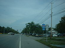
County Route 290
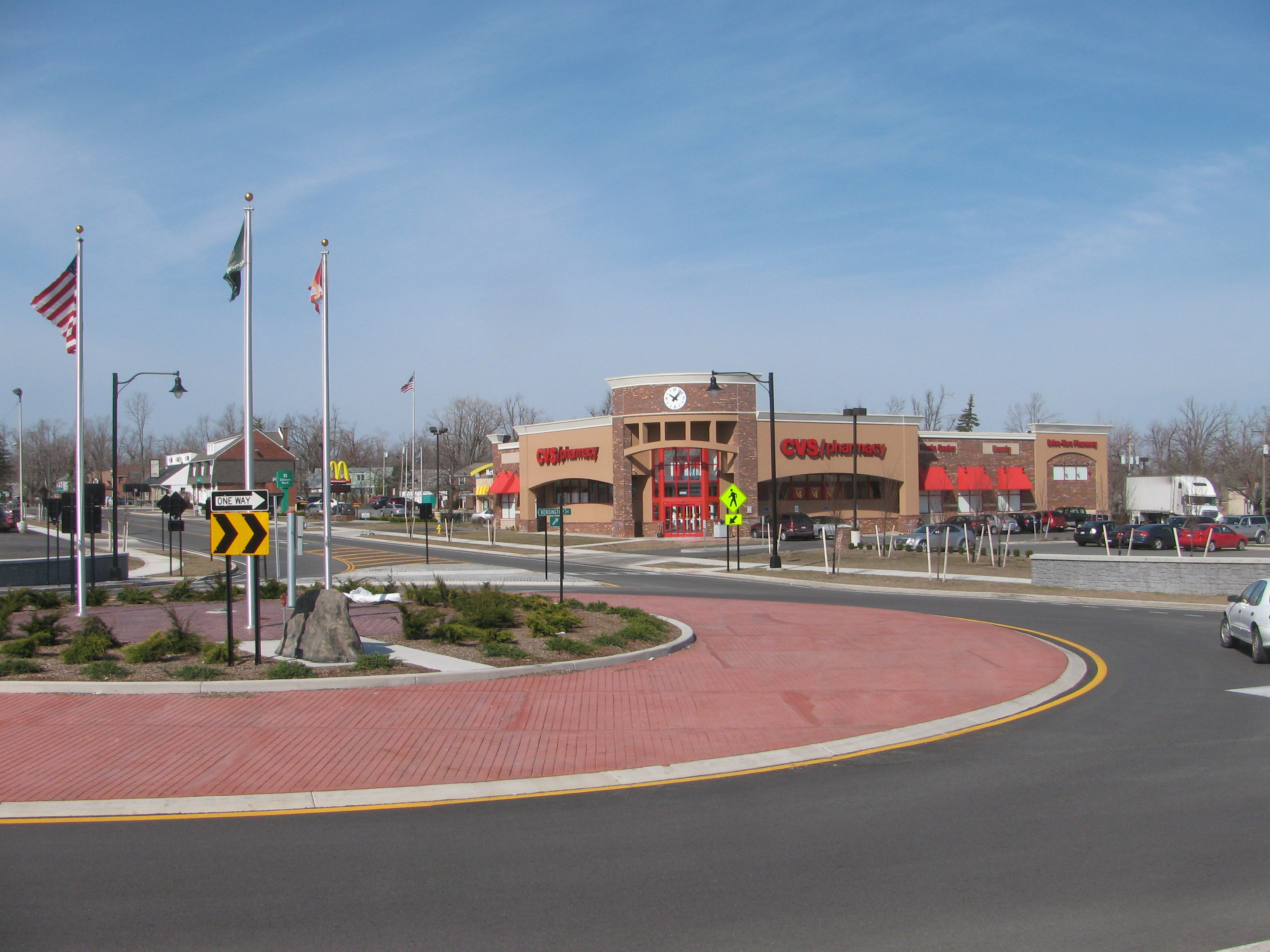
Location: Amherst Length: 4.97 mi[1] (8.00 km) County Route 290 is a well traveled east–west route in the southern part of Amherst. This route is entirely within Amherst. Its west end is at a traffic circle with CR 208 (Kensington Ave.) and NY 240 (Harlem Rd.). As the route heads east it passes in the middle or through the Interstate 90-Interstate 290 interchange. The next major intersection is at Union Rd. (NY 277), then Cayuga Rd. (CR 245), and Aero Dr. (CR 324), and Garrison Rd. (CR 289), Youngs Rd. (CR 554) and finally reaches its eastern terminus at Transit Rd. (NY 78).
 Western terminus at Harlem Road (NY 240) and Kensington Avenue (CR 208) traffic circle in Amherst
County Location Mile[1] Destinations Notes Erie Amherst 0.0 
 NY 240 / CR 208
Traffic circle 1.5  NY 277
Williamsville 2.0  CR 245
2.4  CR 324
2.8  CR 289
3.5  CR 554
4.97 
 NY 78 / CR 275
1.000 mi = 1.609 km; 1.000 km = 0.621 mi Route 294
County Route 294
Location: Amherst Length: 4.4 mi[1] (7.1 km) County Route 294 is a well traveled north–south route in the town of Amherst. This route is entirely within Amherst. Its southern end is at NY 324 (Sheridan Dr.) and NY 277 (North Forest Rd. (continues)). From there it heads north and crosses Maple Rd. (CR 192) and passes Heim Rd. (CR 173), crosses NY 263 (Millersport Hwy.) as it heads north towards its north end at CR 45 (Dodge Rd.)
County Location Mile[1] Destinations Notes Erie Amherst 0.0  NY 277 / NY 324
1.1  CR 192
Getzville 2.7  NY 263
3.0 John James Audubon Parkway Amherst 4.4  CR 45
CR 451.000 mi = 1.609 km; 1.000 km = 0.621 mi Route 295
County Route 295 Location: Amherst Length: 2.1 mi[1] (3.4 km) County Route 295 is a well traveled east–west route in the town of Amherst, a northeast suburb of Buffalo. This route is entirely within Amherst. Its west end is at CR 45 (Dodge Rd.) and travels south from that intersection and turns east just past a local middle school. The route then is east–west in direction and travels to its east end at NY 78 (Transit Rd.) on the Amherst-Clarence town line.
County Location Mile[1] Destinations Notes Erie Amherst 0.0 CR 450.7 Youngs Road 2.1 NY 781.000 mi = 1.609 km; 1.000 km = 0.621 mi Route 297
County Route 297
Location: Amherst Length: 2.6 mi[1] (4.2 km) County Route 297 is an east–west route in the town of Amherst, a northeast suburb of Buffalo. This route lies entirely in Amherst and travels from CR 87 (Hopkins Rd.), across NY 263 (Millersport Hwy.), across CR 186 (New Rd.) west towards its terminus at NY 78 (Transit Rd.) near CR 68 (Stahley Rd.)
County Location Mile[1] Destinations Notes Erie West Amherst 0.0  CR 87
CR 87Amherst 0.6 NY 2630.8  CR 186
Swormville 2.6  NY 78 / CR 68
1.000 mi = 1.609 km; 1.000 km = 0.621 mi Route 299
County Route 299
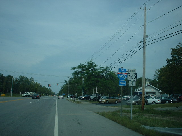
Location: Amherst Length: 6.4 mi[1] (10.3 km) County Route 299 is a heavily traveled east–west route in the town of Amherst, a northeast suburb of Buffalo. This route is entirely in Amherst and crosses many locations in town from West Amherst to Getzville to Swormville. Route 299 begins at an intersection with US 62 (Niagara Falls Blvd.) in Amherst, (West end). It is known as East Robinson Rd., but then picks up the name North French Rd. shortly after you enter the Town of Amherst at an intersection. The road travels east from there intersecting CR 301 (Sweet Home Rd.), NY 270 (Campbell Blvd.), I-990 (Lockport Expwy.), NY 263 (Millersport Hwy.), CR 87 (Hopkins Rd.), CR 45 (Dodge Rd.), then to its east end at an intersection with NY 78 (Transit Rd.) and CR 282 (County Rd.) at the Amherst-Clarence town line. (In Swormville, a hamlet in the eastern part of Amherst and the western part of Clarence).
 North on NY 263 (Millersport Hwy) at CR 299 in Amherst
County Location Mile[1] Destinations Notes Erie West Amherst 0.0  US 62
US 62Getzville 2.8  NY 270
3.2  I-990
I-990Exit 4 (I-990) 3.8 NY 263Swormville 6.4 NY 781.000 mi = 1.609 km; 1.000 km = 0.621 mi Route 301
County Route 301
Location: Amherst Length: 2.4 mi[1] (3.9 km) County Route 301 is a well traveled north–south route in the town of Amherst, a northeast suburb of Buffalo. This route is entirely in Amherst. Route 301 begins at an intersection with CR 232 (N. Ellicott Creek Rd.) and the northern terminus of unsigned NY 952T in Amherst. CR 301 travels north from there intersecting CR 45 (Dodge Rd.), CR 299 (North French Rd.), then its northern terminus at CR 2 (Tonawanda Creek Rd.) in West Amherst. Former New York State Route 356 was routed on Sweet Home Rd. from N. Ellicott Creek Rd. where it was routed from the west and to Dodge Rd. where it turned to go east.
Sweet Home Road extends from CR 130 to CR 2 and consists of two county routes and a reference route: CR 171 from CR 130 to CR 192, NY 952T from CR 192 to CR 232, and CR 301.
County Location Mile[1] Destinations Notes Erie Amherst 0.0  CR 232 / Sweet Home Road (NY 952T)
0.3 CR 45West Amherst 0.9  CR 301
2.4  CR 2
CR 21.000 mi = 1.609 km; 1.000 km = 0.621 mi Route 303
County Route 303
Location: Tonawanda Length: 1.0 mi[1] (1.6 km) County Route 303 is a well traveled north–south route in the town of Tonawanda, north of Buffalo. This route lies entirely within Tonawanda. Its south end is at the Tonawanda city line near NY 425, just north of I-290, from there it travels north through the Town of Tonawanda just east of the City of Tonawanda to its north end at Raintree Pkwy. & Paradise Ln. (The rest of Colvin Blvd. in the Town of Tonawanda that lies south of the NY 425/I-290/CR 130 intersection is numbered CR 118).
County Location Mile[1] Destinations Notes Erie Tonawanda City Line 0.0 Colvin Boulevard Town of Tonawanda 0.9  CR 580
Formerly NY 356 1.0 Raintree Parkway & Paradise Lane 1.000 mi = 1.609 km; 1.000 km = 0.621 mi Route 306
County Route 306 Location: Tonawanda Length: 0.5 mi[1] (0.80 km) County Route 306 is a short east–west route in the Town of Tonawanda, just south of I-290. This route is entirely in Tonawanda. Route 306 runs from its west end at NY 265 (Military Rd.) to its east end at NY 384 (Delaware Ave.) and has only one intersection, almost in the center of the route. On the north side of this intersection there is an exit ramp from I-290 east and an entrance ramp to I-290 west. On the south is Elmwood Ave. (CR 119 north end).
County Location Mile[1] Destinations Notes Erie Tonawanda (town) 0.0  NY 265
0.2 
 I-290 / CR 119
Exit 1 (I-290) 0.5  NY 384
1.000 mi = 1.609 km; 1.000 km = 0.621 mi Route 307
County Route 307
Location: Tonawanda-Amherst/Buffalo City Line Length: 3.6 mi[1] (5.8 km) County Route 307 is an east–west route from the Tonawanda/Buffalo/Kenmore line through the Village of Kenmore then through the southeast part the Town of Tonawanda to its east end at NY 5 (Main St.) at the Buffalo city line at the Buffalo/Amherst line. CR 307 forms the southern border of Tonawanda and north border of Buffalo.
Kenmore Avenue is numbered as three separate county routes along its path: CR 189 in the town of Tonawanda from Grand Island Boulevard (unsigned NY 950C) to the Buffalo city line, CR 550 in the city of Buffalo from the Tonawanda town line to Military Road (NY 265), and CR 307.
County Location Mile[1] Destinations Notes Erie Tonawanda (town) 0.0 NY 265Kenmore 0.5 CR 1191.0 NY 384Amherst-Buffalo Line 3.6 NY 51.000 mi = 1.609 km; 1.000 km = 0.621 mi Route 308
County Route 308
Location: Grand Island Length: 4.0 mi[1] (6.4 km) County Route 308 is a north–south route entirely in the Town of Grand Island. Route 308 runs from its south end at the South Parkway Northbound Ramp near Grand Island Blvd. (NY 324) to its north end at CR 11 (East River Rd.) Along its route it intersects CR 75 (Whitehaven Rd.), and CR 309 (Huth Rd.)
County Location Mile[1] Destinations Notes Erie Grand Island 0.0 South Parkway 1.2  CR 75
CR 753.2  CR 309
4.0  CR 11
CR 111.000 mi = 1.609 km; 1.000 km = 0.621 mi Route 309
County Route 309
Location: Grand Island Length: 1.1 mi[1] (1.8 km) County Route 309 is a short east–west route entirely in the Town of Grand Island. Route 309 runs from its west end at CR 249 (Baseline Rd.) to its east end at CR 308 (Stony Point Rd.) Intersections along this route include local Grand Island Roads.
County Location Mile[1] Destinations Notes Erie Grand Island 0.0  CR 249
1.1  CR 308
1.000 mi = 1.609 km; 1.000 km = 0.621 mi Route 310
County Route 310 Location: Grand Island Length: 1.8 mi[1] (2.9 km) County Route 310 is an east–west roadway entirely in the Town of Grand Island. Route 310 runs from its west end at West River Pkwy, and its service road West River Road, east intersecting I-190 and NY 324 (Grand Island Blvd.) before ending at its east end at CR 249 (Baseline Rd.)
County Location Mile[1] Destinations Notes Erie Grand Island 0.0 West River Parkway (NY 957C) 0.55  I-190
I-190Exit 20 (I-190) 0.68 NY 3241.80 CR 2491.000 mi = 1.609 km; 1.000 km = 0.621 mi Route 313
County Route 313 Location: Cheektowaga-Amherst Length: 1.7 mi[1] (2.7 km) County Route 313 is a north–south route mainly in the Town of Cheektowaga. Its south end is at Genesee St. (unsigned NY 952A). From there it heads north and has major intersections with Maryvale Dr. and Cleveland Dr. (CR 141) before it comes to its north ends at CR 290 (Wehrle Dr.) in Amherst, just across the town line.
County Location Mile[1] Destinations Notes Erie Cheektowaga 0.0 Genesee Street (NY 952A) 0.5 Maryvale Drive 1.4  CR 141
Amherst 1.7 CR 2901.000 mi = 1.609 km; 1.000 km = 0.621 mi Route 315
County Route 315 Location: Cheektowaga Length: 0.8 mi[1] (1.3 km) County Route 315 is an east–west route mainly in the Town of Cheektowaga. Its west end is at the Buffalo city line with Cheektowaga. At that end there is an exit off I-190 to South Ogden St. and this is done by the way of Dingens St. This route has intersections with local roads until its eastern terminus at Harlem Rd. (NY 240).
County Location Mile[1] Destinations Notes Erie Buffalo 0.0 Buffalo city line 0.0 I-190Exit 1 (I-190) Cheektowaga 0.8 NY 2401.000 mi = 1.609 km; 1.000 km = 0.621 mi Route 316
County Route 316
Location: Cheektowaga-Depew Length: 5.3 mi[1] (8.5 km) County Route 316 is an east–west roadway mainly in the Town of Cheektowaga but also into the Village of Depew where this route has its end. Its west end is at Genesee St. (unsigned NY 952A) at an area of the town called "Pine Hill". From there it heads east and has major intersections with Harlem Rd. (NY 240), Union Rd. (NY 277), Dick Rd. (CR 317) at the Cheektowaga/Depew village line. This route then has its eastern terminus at Transit Road (NY 78).
County Location Mile[1] Destinations Notes Erie Cheektowaga 0.0 Genesee Street (NY 952A) 0.3 NY 2401.9 NY 2773.15  CR 317
Depew 5.3 NY 781.000 mi = 1.609 km; 1.000 km = 0.621 mi Route 317
County Route 317
Location: Cheektowaga Length: 1.9 mi[1] (3.1 km) County Route 317 is a well traveled north–south route that is mainly in the Town of Cheektowaga, howvever from its south end at Broadway (NY 130) in Cheektowaga to just north of George Urban Blvd., Dick Rd. forms the western Depew village line. Just north from its southern terminus at Broadway, Dick Rd. intersects Walden Avenue (unsigned NY 952Q). North from Walden, Dick Rd. intersects George Urban Blvd. (CR 316). Then near its north end there is a signalized intersection with a ramp from the eastbound Kensington Expressway (NY 33). This is only to stop traffic flow on Dick Rd. to allow traffic from the eastbound Kensington to exit onto Dick Rd., traffic on Dick Rd. cannot turn at this intersection, only continue on Dick Road. Just north past this intersection, Dick Rd. comes to an end at an intersection with Genesee St. (unsigned NY 952A and former NY 33B) and Cayuga Rd. (CR 245).
County Location Mile[1] Destinations Notes Erie Cheektowaga 0.0  NY 130
0.3 Walden Avenue (NY 952Q) Cheektowaga-Depew line 1.1  CR 316
Cheektowaga 1.7  NY 33
NY 331.9 CR 245 / Genesee Street (NY 952A)Genesee Street was formerly NY 33B 1.000 mi = 1.609 km; 1.000 km = 0.621 mi Route 319
County Route 319 Location: Cheektowaga-Depew Length: 1.4 mi[1] (2.3 km) County Route 319 is an east–west route in the Town of Cheektowaga and the Village of Depew. Route 319 begins as Indian Rd, at its west end at Como Park Blvd. (CR 523). The route heads north shortly until an intersection with Rowley Rd. Route 319 then heads east and continues on Rowley Rd. as Indian Rd. continues north. Route 319, now Rowley Rd., has intersections with local Town and Village Roads until its east end at Borden Rd. (CR 322).
County Location Mile[1] Destinations Notes Erie Cheektowaga 0.0  CR 523
Depew 1.4  CR 322
1.000 mi = 1.609 km; 1.000 km = 0.621 mi References
External links
County routes in Erie County, New York Categories:- County routes in Erie County, New York
Wikimedia Foundation. 2010.