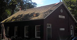
- Conduit Road Schoolhouse
-
Conduit Road Schoolhouse

Location: 4954 MacArthur Boulevard, NW
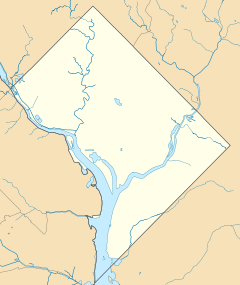
Washington, D.C.Coordinates: 38°55′17″N 77°5′59″W / 38.92139°N 77.09972°WCoordinates: 38°55′17″N 77°5′59″W / 38.92139°N 77.09972°W Built: 1874 Architectural style: vernacular Governing body: District of Columbia NRHP Reference#: 73000220 [1] Added to NRHP: November 30, 1973 The Conduit Road Schoolhouse is an historic school, located at 4954 MacArthur Boulevard, Northwest, Washington, D.C., in the Palisades neighborhood.
History
It was built as a one room schoolhouse, on Conduit Road. It replaced a school of 1864, which burned down. It closed on 1928, and served as a branch of the public library. In 1965, it was saved for use as the Children's Museum.[2]
See also
References
- ^ "National Register Information System". National Register of Historic Places. National Park Service. 2008-04-27. http://nrhp.focus.nps.gov/natreg/docs/All_Data.html.
- ^ http://pdfhost.focus.nps.gov/docs/NRHP/Text/73000220.pdf
U.S. National Register of Historic Places Topics Lists by states Alabama • Alaska • Arizona • Arkansas • California • Colorado • Connecticut • Delaware • Florida • Georgia • Hawaii • Idaho • Illinois • Indiana • Iowa • Kansas • Kentucky • Louisiana • Maine • Maryland • Massachusetts • Michigan • Minnesota • Mississippi • Missouri • Montana • Nebraska • Nevada • New Hampshire • New Jersey • New Mexico • New York • North Carolina • North Dakota • Ohio • Oklahoma • Oregon • Pennsylvania • Rhode Island • South Carolina • South Dakota • Tennessee • Texas • Utah • Vermont • Virginia • Washington • West Virginia • Wisconsin • WyomingLists by territories Lists by associated states Other Categories:- Buildings and structures completed in 1765
- Schools on the National Register of Historic Places in Washington, D.C.
Wikimedia Foundation. 2010.

