- Senator George Sellar Bridge
-
Senator George Sellar Bridge 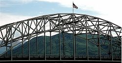
Crosses Columbia River Locale East Wenatchee, Washington / West Wenatchee, Washington Maintained by State of Washington Design Tied-arch bridge Total length 1,208 feet (368 m) Longest span 480 feet (150 m) Clearance below 85 feet (26 m)[1] Opened 1950 Replaces Columbia River Bridge (Wenatchee, Washington) Coordinates 47°24′36″N 120°17′41″W / 47.41°N 120.29472°WCoordinates: 47°24′36″N 120°17′41″W / 47.41°N 120.29472°W 

Nearest city: Wenatchee, Washington Area: less than one acre Built: 1950 Governing body: State MPS: Bridges of Washington State MPS NRHP Reference#: 95000623[2] Added to NRHP: May 24, 1995 The Senator George Sellar Bridge, also known as the Columbia River Bridge at Wenatchee, Washington was built in 1950 to carry U.S. Route 2 across the Columbia River. The steel suspended tied-arch bridge has a main span of 480 feet (150 m) with 224-foot (68 m) anchor arms. The suspended portion of roadway comprises 352 feet (107 m) and is 54 feet (16 m) wide, carrying four lanes with a median divider strip at a height of 180 feet (55 m) above mean water level. The 1950 bridge replaced a bridge built in 1908 at the same location. The new bridge was recognized by the American Institute of Steel Construction as the most beautiful bridge of 1950 for spans over 400 feet (120 m) in length.[3]
The bridge's engineer was R. W. Finke. The contractor was the General Construction Company of Seattle, using steel fabricated by the American Bridge Company. The bridge rests on two concrete piers in the river, with the central arch between them, and cantilever spans extending to concrete abutments high on the riverbanks.[3] Now named the Senator George Sellar Bridge after a Washington state senator, the bridge carries Washington State Route 285 since the construction of the Richard Odabashian Bridge for Route 2 farther north. An additional lane was added in 2009-2010.[4] The bridge was placed on the National Register of Historic Places on May 24, 1995.[2]
References
- ^ "National Register of Historic Places Registration Form: Columbia River Bridge at Wenatchee". National Park Service. https://fortress.wa.gov/dahp/wisaard/documents/RN/0/0/418.pdf. Retrieved 2011-09-01.
- ^ a b "National Register Information System". National Register of Historic Places. National Park Service. 2010-07-09. http://nrhp.focus.nps.gov/natreg/docs/All_Data.html.
- ^ a b Krier, Robert H.; Barber, J. Byron; Bruce, Robert; Holstine, Craig (December 12, 1991). "National Register of Historic Places Registration Form: Columbia River Bridge at Wenatchee". National Park Service. https://fortress.wa.gov/dahp/wisaard/documents/RN/0/0/418.pdf. Retrieved 1 September 2011.
- ^ "George Sellar Bridge to Open for Pedestrians". Manson Village Tribune. September 22, 2009. http://mansontribune.com/component/content/article/1174-george-sellar-bridge-to-open-for-pedestrians.html. Retrieved 1 September 2011.
U.S. National Register of Historic Places Topics Lists by states Alabama • Alaska • Arizona • Arkansas • California • Colorado • Connecticut • Delaware • Florida • Georgia • Hawaii • Idaho • Illinois • Indiana • Iowa • Kansas • Kentucky • Louisiana • Maine • Maryland • Massachusetts • Michigan • Minnesota • Mississippi • Missouri • Montana • Nebraska • Nevada • New Hampshire • New Jersey • New Mexico • New York • North Carolina • North Dakota • Ohio • Oklahoma • Oregon • Pennsylvania • Rhode Island • South Carolina • South Dakota • Tennessee • Texas • Utah • Vermont • Virginia • Washington • West Virginia • Wisconsin • WyomingLists by territories Lists by associated states Other Crossings of the Columbia River Upstream
Old Wenatchee BridgeSenator George Sellar Bridge Downstream
Rock Island Railroad BridgeCategories:- National Register of Historic Places in Washington (state)
- Bridges on the National Register of Historic Places in Washington (state)
- Tied arch bridges
- Bridges completed in 1950
- Buildings and structures in Chelan County, Washington
- Buildings and structures in Douglas County, Washington
- Bridges over the Columbia River
- Road bridges in Washington (state)
- Washington Registered Historic Place stubs


Wikimedia Foundation. 2010.