Columbia River Crossing

Columbia River Crossing

The Columbia River Crossing is a joint megaproject between the United States Oregon and Washington departments of transportation to address problems with US Interstate 5 where it crosses the Columbia River. Founded in 2005, it looks to replace the existing Interstate Bridge and other associated changes south of SR-500. "Project partners" include the Federal Highway Administration and the Federal Transit Administration, cities of Vancouver and Portland, the Southwest Washington Regional Transportation Council, Metro, and transit agencies C-TRAN and Trimet. Other agencies are involved as part of "task forces".

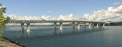
Concept drawing for a possible deck truss bridge, seen from the southeast.

A draft environmental impact statement was published in May of 2008, with a final EIS published in the Federal Register on September 23, 2011. The full buildout as of May 2011 has a range of probable cost of $3.1 to $3.6 billion for five miles of highway and transit work, to include a double-deck truss bridge with ten lanes for auto traffic on the top deck, with public transportation, bicycles and pedestrians below. Construction is expected to begin no sooner than 2013 and to last five to seven years.

External links


Wikimedia Foundation. 2010.

Игры ⚽ Поможем сделать НИР

Look at other dictionaries:

  • Columbia River Bridge (Bridgeport, Washington) — Columbia River Bridge at Bridgeport U.S. National Register of Historic Places …   Wikipedia

  • Columbia River — Coordinates: 46°14′39″N 124°3′29″W / 46.24417°N 124.05806°W / 46.24417; 124.05806 …   Wikipedia

  • List of crossings of the Columbia River — This is a list of bridges and other crossings of the Columbia River from the Pacific Ocean upstream to its source. Contents 1 Crossings 1.1 Oregon Washington 1.2 Washington 1.3 …   Wikipedia

  • Saskatchewan River Crossing, Alberta — Superimpose base = AB towns highways.png base width = 200px base caption = Alberta roads and towns float = Dot yellow.svg float width = 10px float caption = Saskatchewan River Crossing x = 51 y = 188 Saskatchewan River Crossing in Alberta… …   Wikipedia

  • Historic Columbia River Highway —     Historic Columbia River Highway …   Wikipedia

  • Columbia Slough — Coordinates: 45°38′36″N 122°46′07″W / 45.64333°N 122.76861°W / 45.64333; 122.76861 …   Wikipedia

  • Columbia (fleuve) —  Pour les articles homonymes, voir Columbia. Cet article possède un homophone, voir Colombia. Columbia (Columbia River, Wimahl, Nch’i Wàna) …   Wikipédia en Français

  • river — river1 riverless, adj. riverlike, adj. /riv euhr/, n. 1. a natural stream of water of fairly large size flowing in a definite course or channel or series of diverging and converging channels. 2. a similar stream of something other than water: a… …   Universalium

  • Columbia Valley AVA — This article refers to the wine appellation in the United States. For the Columbia Valley in British Columbia, Canada, see Columbia Valley Columbia Valley AVA (wine region) …   Wikipedia

  • Columbia Valley (Lower Mainland) — This article is for the valley and farming community south of Cultus Lake, British Columbia. For the region in the East Kootenay region of British Columbia see Columbia Valley. For the wine region in the United States see Columbia Valley AVA. For …   Wikipedia

Share the article and excerpts

Direct link
Do a right-click on the link above
and select “Copy Link”