- Chestnut Street Bridge (Detroit)
-
Chestnut Street Bridge
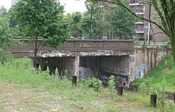 Chestnut Street bridge from the northeast
Location: Detroit, Michigan Coordinates: 42°20′41″N 83°2′3″W / 42.34472°N 83.03417°WCoordinates: 42°20′41″N 83°2′3″W / 42.34472°N 83.03417°W Built: 1929 Architect: Grand Trunk Western Railroad Architectural style: Other Governing body: Local MPS: Highway Highway Bridges of Michigan MPS NRHP Reference#: 00000115[1] Added to NRHP: February 18, 2000 The Chestnut Street Bridge is located where Chestnut Street passes over the Dequindre Cut (formerly owned by the Grand Trunk Western Railroad) in Detroit, Michigan. It was listed on the National Register of Historic Places in 2000.[1]
Contents
History
By the 1920s, there were over 400 industries operating on Detroit's east side. However, the combination of the city's haphazard streetplan, the expansion of large factories, and the substantial network of rail tracks conspired to slow traffic within the city, particularly in the east-west direction.[2] In 1923, the city of Detroit and Grand Trunk railroad began a plan to build 22 grade separations; both parties agreed to share the cost.[2]
One of the tracks to be regraded was the line paralleling St. Aubin. These tracks ran from the northwest, where they connected with a network of other lines, to the southeast, where the tracks turned to parallel the river and supplied a number of large factories, including the Detroit-Michigan Stove Plant, the United States Rubber Company Plant, and the Parke-Davis Laboratories. The tracks terminated at the Brush Street Depot in downtown Detroit.[2]
By March 1930, 16 of the crossings of what now is known as the "Dequindre Cut" were finished, including the Chestnut Street bridge.[2] The nearby Antietam Avenue Bridge was completed soon thereafter. In 1964, the Antietam Avenue Bridge and the Chestnut Street Bridge were teamed as a one-way pair.[2] In the 1980s, the railway was abandoned,[3] and ownership changed hands.[4]
As of 2008, the Dequindre Cut is being turned into a rail trail.[3]
Significance
The Dequindre Cut is in good condition, and the course of the Cut and how it relates to the street grid is apparent from the Antietam Street bridge. The bridge is good evidence of the grade separation effort early in the twentieth century.[2]
References
- ^ a b "National Register Information System". National Register of Historic Places. National Park Service. 2008-04-15. http://nrhp.focus.nps.gov/natreg/docs/All_Data.html.
- ^ a b c d e f Staff (May 16, 2002). "Chestnut – Grand Trunk Railroad". Historic Bridges. Michigan Department of Transportation. http://www.michigan.gov/mdot/0,1607,7-151-9620_11154_11188-29422--,00.html.
- ^ a b "Walter Wasacz". Dequindre Cut: The Missing Link. Model D. http://www.modeldmedia.com/features/dequindre.aspx.
- ^ "Trail Development Assistance Response Team" (PDF). Abandoned Rail Corridor Inventory and Assessment, Final Report. GreenWays Initiative: Planning for Detroit's Rail-Trails. October 2002. pp. 25–30. http://www.railtrails.org/resources/documents/resource_docs/Detroit_Plan.pdf.
External links
- Chestnut Street Bridge from HistoricBridges.org: multiple photographs.
City of Detroit Architecture · Culture · Detroit River · Economy · Freeways · Government · History · Historic places · International Riverfront · Media · Music · Neighborhoods · Parks and beaches · People · Skyscrapers · Sports · Theatre · Tourism · Transportation

U.S. National Register of Historic Places Topics Lists by states Alabama • Alaska • Arizona • Arkansas • California • Colorado • Connecticut • Delaware • Florida • Georgia • Hawaii • Idaho • Illinois • Indiana • Iowa • Kansas • Kentucky • Louisiana • Maine • Maryland • Massachusetts • Michigan • Minnesota • Mississippi • Missouri • Montana • Nebraska • Nevada • New Hampshire • New Jersey • New Mexico • New York • North Carolina • North Dakota • Ohio • Oklahoma • Oregon • Pennsylvania • Rhode Island • South Carolina • South Dakota • Tennessee • Texas • Utah • Vermont • Virginia • Washington • West Virginia • Wisconsin • WyomingLists by territories Lists by associated states Other Industrial landmarks in metropolitan Detroit City Antietam Avenue Bridge • Cass Motor Sales • Chestnut Street Bridge • Crescent Brass and Pin Company Building • Detroit Edison Company Willis Avenue Station • Dry Dock Complex • Edwin S. George Building • Globe Tobacco Building • Graybar Electric Company Building • Michigan Bell and Western Electric Warehouse • Milwaukee Junction • New Amsterdam Historic District • Stroh River Place (Parke-Davis Plant) • Riverwalk Hotel (Parke-Davis Laboratory) • Piquette Avenue Industrial Historic District • Piquette Plant • Frederic M. Sibley Lumber Company Office Building • Frederick Stearns Building • Russell Industrial Center • Stuber-Stone Building • West Jefferson Avenue – Rouge River Bridge

Suburban Ford River Rouge Complex • Ford Valve Plant • The Henry Ford • Willow Run
Categories:- Bridges in Detroit, Michigan
- Bridges on the National Register of Historic Places in Michigan
- Railway-related listings on the National Register of Historic Places
- Bridges completed in 1929
- Railroad bridges in Michigan

Wikimedia Foundation. 2010.