- Mi'ilya
-
Mi'ilya Hebrew transcription(s) – Hebrew מִעִלְיָא – ISO 259 Miˁilyaˀ – Also spelled Malia (unofficial) Arabic transcription(s) – Arabic معليا 
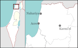
LogoCoordinates: 33°1′30.57″N 35°15′34.41″E / 33.0251583°N 35.2595583°ECoordinates: 33°1′30.57″N 35°15′34.41″E / 33.0251583°N 35.2595583°E District North Founded Prior to 1160[1] Government – Type Local council (from 1957) Area – Total 1,365 dunams (1.4 km2 / 0.5 sq mi) Population (2009)[2] – Total 2,800 Mi'ilya (Arabic: معليا, Hebrew: מִעִלְיָא) is an Arab local council in the western Galilee in the North District of Israel. Its name during the Kingdom of Jerusalem era in Galilee was Castellum Regis.[1] All of its inhabitants are Christians.
Contents
History
Archaeological excavations in Mi'ilya gives indication of inhabitation from the Late Bronze Age and Iron Age, as well as Hellenistic, Roman, Byzantine, Crusader, Mamluk and Ottoman periods.[3]
The Arab geographer, Al-Dimashqi, noted the "fine castle", and that close it was a very pleasant valley, where musk-pears and large citrons were grown.[4]
In 1596, Mi'ilya appeared in Ottoman tax registers as being in the Nahiya of Akka of the Liwa of Safad. It had a population of 15 Muslim households and 2 Christian households and paid taxes on wheat, barley, olives, and goats or beehives.[5]
In 1881 Mi'ilya was described as being a large and well-built village of stone, containing 450 Christians, surrounded by olives and arable land.[6]
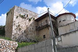
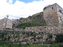
King's castle
The King's castle in Mi'ilya dates back at least to 1160, when King Baldwin III of Jerusalem granted title to it to a certain John of Haifa and his heirs. In 1182, Baldwin IV granted it to his uncle, Jocelyn III. At this time it was called "The new castle in the mountains of Acre". By 1187, the castle fell to Saladin. Later, in the early 1200, ownership passed to the Teutonic Knights. However, the importance of the castle of Mi'ilya was by this time superseded by the Montfort Castle.[7]
Modern history
At the time of the 1931 census of Palestine, Mi'ilya had 138 occupied houses and a population of 553 Christians, 25 Muslims and 1 Druse.[8] By 1945, this had increased to 790 Christians and 110 Muslims.[9]
After the 1948 Arab-Israeli war, Mi'ilya was incorporated into the newly established State of Israel. It was recognized as a local council in 1957.
See also
References
- ^ a b Ellenblum, 2003, p. 41.
- ^ "Table 3 - Population of Localities Numbering Above 2,000 Residents and Other Rural Population". Israel Central Bureau of Statistics. 2010-06-30. http://www.cbs.gov.il/population/new_2010/table3.pdf. Retrieved 2010-10-30.
- ^ Porat, 2009, Mi‘ilya, the Church Square Preliminary Report
- ^ leStrange, 1890, p.495
- ^ Wolf-Dieter Hütteroth and Kamal Abdulfattah (1977), Historical Geography of Palestine, Transjordan and Southern Syria in the Late 16th Century, Erlanger Geographische Arbeiten, Sonderband 5. Erlangen, Germany: Vorstand der Fränkischen Geographischen Gesellschaft, p. 194
- ^ Conder and Kitchener, 1881, p.149
- ^ Pringle, 1998, p. 30
- ^ E. Mills, ed. (1932), Census of Palestine 1931. Population of Villages, Towns and Administrative Areas, Jerusalem: Government of Palestine, p. 102
- ^ Government of Palestine, Village Statistics 1945.
Bibliography
- Abu-‘Uqsa, Hanaa (2005): Mi‘ilya Final Report Hadashot Arkheologiyot – Excavations and Surveys in Israel, No. 117.
- Conder, Claude Reignier and H.H. Kitchener (1881): The Survey of Western Palestine: memoirs of the topography, orography, hydrography, and archaeology. London:Committee of the Palestine Exploration Fund. vol 1
- Ellenblum, Ronnie (2003), Frankish Rural Settlement in the Latin Kingdom of Jerusalem, Cambridge University Press, ISBN 0521521874, 9780521521871, http://books.google.com/books?id=9kgdbzbUMMwC
- leStrange, Guy (1890), Palestine Under the Moslems: A Description of Syria and the Holy Land from A.D. 650 to 1500, Committee of the Palestine Exploration Fund, http://www.archive.org/details/palestineundermo00lestuoft, London,
- Porat, Leea (2009): Mi‘ilya, the Church Square Preliminary Report Hadashot Arkheologiyot – Excavations and Surveys in Israel, No. 121.
- Pringle, Denys (1998), The Churches of the Crusader Kingdom of Jerusalem: A Corpus, Cambridge University Press, ISBN 0521390370, http://books.google.com/?id=2Y0tA0xLzwEC
- Smithline, Howard (2008): Mi‘iliya Final Report Hadashot Arkheologiyot – Excavations and Surveys in Israel, No. 120.
External links
- Mi'ilya, statistics on land and population at Palestine Remembered
Crusader sites in Israel State of Israel Abu Ghosh • Achziv • Acre • Arsuf • Ashkelon • Ateret Fortress • Azor • Bayt 'Itab • Beit Guvrin • Beit She'an • Belvoir • Burgata • Caesarea • Cafarlet • Château Pèlerin • Destroit • Givat Titora • Ein Hemed • Jerusalem • Khirbat Rushmiya • Margaliot • Mi'ilya • Migdal Afek • Montfort • Qalansawe • Qaqun • Qastal • Qula • Safed • Taibe • Tel Afek • Tel Hanaton • Tel Tzafit • Tel Tzova • Tel Yavne • Tiberias • Tzippori • Umm Khalid • Yehiam
Categories:- North District (Israel)
- Local councils in Israel
- Arab localities in Israel
- Arab Christian localities in Israel
- Castles of the Teutonic Knights
Wikimedia Foundation. 2010.


