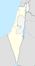
- Bu'eine Nujeidat
-
Bu'eine Nujeidat Hebrew transcription(s) – Hebrew בועיינה-נוג'ידאת – ISO 259 Buˀéine - Nuǧeidaˀt Arabic transcription(s) – Arabic بعينة-نجيدات Coordinates: 32°48′26.68″N 35°22′2.2″E / 32.8074111°N 35.367278°ECoordinates: 32°48′26.68″N 35°22′2.2″E / 32.8074111°N 35.367278°E District North Government – Type Local council (from 1980) Area – Total 7,058 dunams (7.1 km2 / 2.7 sq mi) Population (2006) – Total 7,900 Bu'eine Nujeidat is an Arab local council in the North District of Israel. Made up of two villages, Bu'eine and Nujeidat, they merged in 1987 and were recognized as one local council in 1996. According to the Israel Central Bureau of Statistics (CBS), the population of 7,900 inhabitants (2006) is majority Muslim with a growth rate of 2.3%.
Bu'eine was an Arab village, its name derived from the nearby ancient village of Beit Anat. Nujeidat was also an Arab village, established by soldiers from Nejd who came to fight with Saladin's army in the 12th century. Known as the Arab al-Nujeidat or the "Arabs of Nejd", they gave their tribal name to the village.
See also
Bibliography
- Hadawi, Sami (1970), Village Statistics of 1945: A Classification of Land and Area ownership in Palestine, Palestine Liberation Organization Research Center, http://www.palestineremembered.com/Articles/General-2/Story3150.html p.62
Categories:- North District (Israel)
- Local councils in Israel
- Arab localities in Israel
- Israel geography stubs
Wikimedia Foundation. 2010.

