- Mas'ade
-
Mas'ade
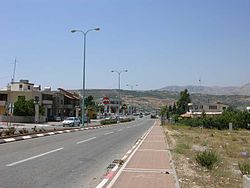
مسعدةMain road with Hermon slopes in the background Country  Israel
  Syria . Occupied in 1967 by Israel, which applied Israeli law there, but still claimed by Syria.
Israeli District North District Israeli Subdistrict Golan Syrian Governorate Quneitra Governorate Syrian District Quneitra District Mas'ade (Arabic: مسعدة, Hebrew: מַסְעַדֶה) is a Druze village in the Golan Heights. It covers an area of 11,985 dunams, and has a population of 3,200. It was given the status of a local council in 1982.
Near Mas'ade are Lake Ram and Odem Forest.
Mas'ade is located at the intersection of Route 99, which leads west to Kiryat Shmona, and Route 98, which leads north to Mount Hermon and south to the Kinneret.
Quneitra Governorate Cities 

Towns and villages Al ‘Al · Beer Ajam · Buq'ata · Ein Qiniyye · Ghajar · Jubata ez-Zeit · Majdal Shams · Mas'ade · ShaytaCoordinates: 33°13′59.26″N 35°45′27″E / 33.2331278°N 35.7575°E
Categories:- North District (Israel)
- Druze localities in Israel
- Quneitra Governorate
- Israel geography stubs
- Syria geography stubs
Wikimedia Foundation. 2010.

