- Dieppe maps
-
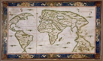
 World map, by Guillaume Brouscon, 1543.
The Dieppe maps are a series of world maps produced in Dieppe, France, in the 1540s, 1550s and 1560s. They are large hand-produced maps, commissioned for wealthy and royal patrons, including Henry II of France and Henry VIII of England. The Dieppe school of cartographers included Pierre Desceliers, Johne Rotz, Guillaume Le Testu, Guillaume Brouscon and Nicholas Desliens.
Contents
Existing Dieppe maps
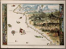 Jave La Grande's east coast: from Nicholas Vallard's atlas, 1547. This is part of an 1856 copy of one of the Dieppe Maps. Copy held by the National Library of Australia.
The Dieppe Maps known to have existed into modern times include the following [1][2][3]
- Johne Rotz, Boke of Idrography, 1542. British Library, London
- Guillaume Brouscon, world chart, 1543, Huntington Library, Los Angeles, California
- Pierre Desceliers, "Royal" world chart, 1546. John Rylands Library, University of Manchester
- Anonymous, "Harleian" or "Dauphin" world chart. c1547. British Library, London
- Anonymous, made for Nicholas Vallard, portolan atlas, c1547. Huntington Library, Los Angeles, California
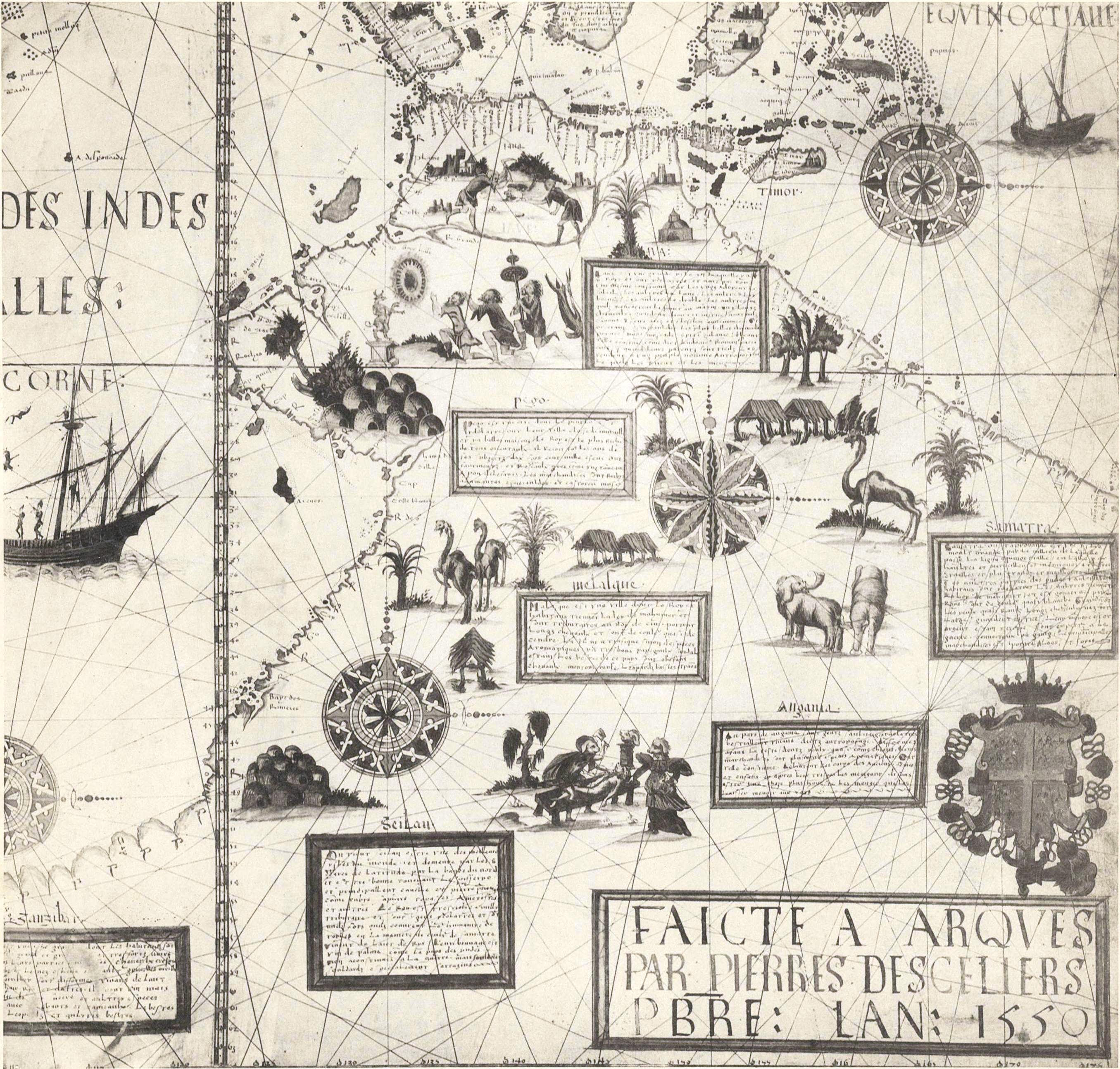
- Pierre Desceliers, world chart, 1550. British Library, London
- Pierre Desceliers, world chart, 1553. Vienna (Destroyed)
- Guillaume Le Testu, Cosmographie Universelle, 1555. Bibliothèque du Service historique de l‘Armée de Terre, Paris
- Anonymous, portolan atlas -attributed to Pierre Desceliers, world chart. c1555. Morgan Library, New York
- Guillaume Le Testu, world chart, 1566. Bibliothèque Nationale de France, Paris
- Nicholas Desliens, world chart, c1541-1561. Dresden (Destroyed)
- Nicholas Desliens, world chart, 1566. Bibliothèque Nationale de France, Paris
- Nicholas Desliens, world chart, 1567. National Maritime Museum, Greenwich
- Attributed to Nicholas Desliens, world chart, c1568. National Maritime Museum, Greenwich
Sarah Toulouse has published a more detailed and comprehensive list of 37 charts and atlases made between 1542 and 1635 and belonging to the Dieppe or Norman school of marine cartography.[4]
The Dieppe School of mapmaking
Because many of the inscriptions on the Dieppe maps are written in French, Portuguese or Gallicised Portuguese, it has often been assumed that the Dieppe school of mapmakers were working from Portuguese sources that no longer exist. It has been assumed that Portuguese cartographers were bribed for information of the latest discoveries, despite the official Portuguese Politica de sigilo (policy of silence). The Cantino map of 1502 (not a Dieppe school map) shows evidence of second hand Portuguese sources, and this has been taken by some as supporting evidence for this assumption.[5]
A common feature of most of the Dieppe world maps (see Vallard 1547, Desceliers 1550) are the compass roses and navigational rhumb lines, suggestive of a sea-chart. However, they are best understood as works of art, clearly intended to be spread out on a table, and containing information on the latest discoveries, side by side with mythological references and illustrations. For example, the Desceliers 1550 map carries descriptions of early French attempts to colonise Canada, the conquests of Peru by the Spanish and the Portuguese sea-trade among the Spice Islands. On the same map can be found descriptions of legendary Cathay, king Prester John in Ethiopia, and the race of Amazons in Russia.[6] Other Dieppe maps also carry fictitious features such as the Marco Polo inspired Zanzibar/Îles des Geanz. (see Vallard 1547, Rotz 1542 and Dauphin c1536-42). As with other maps made before the 17th century, the Dieppe maps show no knowledge of longitude. While latitude could be marked in degrees as observed by astrolabe or quadrant, easting could only be given in distance.[7] Mercator's projection first appeared in 1568-9, a development too late to influence the Dieppe cartographers.
Most of the Dieppe maps depict a large land mass entitled Jave la Grande, between what is now Indonesia and Antarctica. In the English-speaking world particularly, academic and popular interest in the Dieppe maps over the last 150 years has focused largely on this feature of the maps. This is because Jave la Grande is thought by some writers to provide clues of a possible Portuguese exploration of Australia's coasts in the 1520s. However, the most recent academic writings on the Dieppe maps by Carile(1997), Brunelle (2007) and King (2009) have suggested the maps need to be considered in their entirety, and consideration needs to be given to what they reveal about various influences on the mapmakers, as well as French aspirations. This group of writers argue that the maps are not necessarily literal records of voyages of exploration.
The Dieppe maps as evidence of French territorial aspirations
Gayle K. Brunelle's work
 World map of Nicolas Desliens, 1566.
Professor Gayle K. Brunelle of California State University has argued that, although the Dieppe school of cartographers was active for only a generation—from about 1535 to 1562—the cartographers associated with it were acting as propagandists for French geographic knowledge and territorial claims in the New World. The decades when the Dieppe school was flourishing were also the decades in which French trade with the New World was at its 16th century height, in terms of the North Atlantic fish trade, the still fledgling fur trade, and, most important for the cartographers, the rivalry with the Portuguese for control of the coasts of Brazil and the supplies of lucrative Brazilwood. Brunelle says that the Dieppe cartographers accessed cartographic skills and geographic knowledge from Portuguese mariners, pilots, and geographers working in France, at the same time as they were producing maps meant to emphasize French dominion over the New World, both in Newfoundland and in Brazil, that the Portuguese also claimed. She noted that, in design and decorative style the Dieppe school maps represented a blending of the latest geographical and nautical knowledge circulating in Europe (and the portolan style of depicting coastlines), with older conceptualizations of world geography deriving from Ptolemy and mediaeval cartographers and explorers such as Marco Polo. Renaissance mapmakers such as those based in Dieppe relied heavily on each other's work, as well as on maps from previous generations, and thus their maps represented a mixture of old and new data and even differing conceptualizations of space, often coexisting uneasily in the same map.[8]
Other writers on French world views and the Dieppe Maps
The Dieppe maps all depict the southern continent, Terra Australis, incorporating a huge promontory extending northward called "Jave la Grande". According to the French geographer Numa Broc, Terra Australis found its most inspired illustrator in pilot-cartographer of Le Havre, Guillaume Le Testu.[9] Le Testu's Cosmographie Universelle, the sumptuous atlas he presented in 1556 to Coligny, Grand Admiral of France, constituted a veritable encyclopaedia of the geographic and ethnographic knowledge of the time. French historian Frank Lestringant has said: "The nautical fiction of Le Testu fulfilled the conditions of a technical instrumentality, while giving to King Henry II and his minister, Admiral Coligny, the… anticipatory image of an empire that awaited to be brought into being".[10] In the Cosmographie twelve vividly coloured charts are devoted to a survey of the fictitious continent Terra Australis. In these charts, Le Testu drew the outlines of an enormous Austral continent which covered the southern part of the globe and filled a considerable part of the Indian Ocean. This imaginary land derived from the Antichthone of the Greeks and had already been reactivated, notably by the mathematician and cosmographer Oronce Fine (1531) and by Le Testu's predecessors of the Dieppe school. According to the Portuguese historian Paolo Carile, the attitude of Le Testu reveals a cultural conflict between the old cosmographic beliefs and the demands of an empirical concept of geographical and ethnographical knowledge, influenced by the rigour of his Calvinist faith. Carile notes that while on the iconographic side Le Testu depicts an Austral Continent with strangely tropical conditions incorporating beasts drawn from fantasy and old legends, on the other side he nullifies these leaps of imagination by his admission that the land shown as part of the Terra Australis was still unknown and what was marked out on his map was based solely on imagination and surmise.[11]
Dependence of the Dieppe school on the cosmography of Oronce Fine and Johannes Schoener
The cartographers of the Dieppe school incorporated into their world maps the cosmographic concepts of Oronce Fine, the first Professor of Mathematics at the Collège Royal in Paris (now the Collège de France). His 1531 world map was published in 1532 in the Novus Orbis Regionum ac Insularum. Fine’s cosmography was derived from that of the German mathematician, Johannes Schoener.[12] In his study of Schöner‘s globes, Franz von Wieser, found that the derivation of Fine’s mappemonde from them was “unverkennbar” (“unmistakeable”).[13] Lucien Gallois noted in 1890, as Franz von Wieser had done before him, the undeniable “ressemblance parfaite” (“perfect resemblance”) between Fine’s 1531 mappemonde and Schoener’s 1533 globe.[14] Schoener’s globe of 1523 also closely resembled Fine’s mappemonde, proving that Schoener's cosmographic concepts pre-dated those of Fine. Albert Anthiaume wrote in 1911:
“ Whence had the Norman cartographers drawn the idea of this continent [la Terre Australe]? From the bicordiform mappemonde of Oronce Fine (1531), which he in turn had borrowed, according to Gallois, from Schoener....Most of the Norman cartographers, and particularly Le Testu, knew the works of Oronce Fine.[15]
” One place name in particular on the Dieppe maps, the baie bresille on northwest coast the 1542 Rotz map’s Lande of Java, which appears as Baye bresille on the Harleian, Baye bresill on the Desceliers and Baie Braecillie on Le Testu’s Grande Jave of 1556, illustrates the reliance of their makers on the Schoener/Fine cosmography. Armand Rainaud noted in 1893 that this appellation, “without doubt comes from the globes of Schoener and the maps of Oronce Fine”.[16] On Fine’s 1531 mappemonde, BRASIELIE REGIO is shown as part of the Terra Australis lying to the east of Africa and to the south of Java, just where Schoener located BRASIELIE REGIO on his 1523 globe, and where the Dieppe maps locate their Baye Bresille.[17]
Another indication of this reliance is given by the placement of CATIGARA (Kattigara) on the western coast of South America on the mid-1540s Harleian mappemonde and on Le Testu’s 1556 map of western South America: the same location it occupied on Fine’s 1531 mappemonde and on Schoener’s 1523 and 1533 globes. Kattigara (or Cattigara) was understood by the 2nd century Alexandrian geographer Claudius Ptolemy to be a port and emporium on the eastern side of the Sinus Magnus, or Great Gulf, the actual Gulf of Thailand.[18] The 1507 Waldseemüller map shows Catigara in this location. Following the 1519-1521 circumnavigation of the world by the expedition led by Ferdinand Magellan and completed after his death in the Philippines by Sebastian de Juan Sebastián Elcano, Schoener identified the Pacific Ocean with Ptolemy’s Sinus Magnus, which he labelled on his 1523 globe, SINUS MAGNUS EOV[um] MARE DE SUR (the Great Gulf, Eastern Sea, South Sea”).[19] The eastern side of the Sinus Magnus, which Schoener took to be the peninsula of India Superior (Indochina) where Cattigara was located, was therefore identified by him with South America, which on his 1533 globe bears the inscription, America, Indiae superioris et Asiae continentis pars (“America, a part of India Superior and of the Asian continent”). Cattigara was accordingly located on Schoener’s 1523 and 1533 globes on the western coast of South America. CATIGARA occupied the same location on Fine’s mappemonde, as it also did on the Dieppe school maps, the mid-1540s Harleian mappemonde and Le Testu’s 1556 map of western South America.
La Popelinière and French colonial expansion
 Globe by Jacques de Vau de Claye (1583) showing "Terre Australle".
The extent of French knowledge concerning Terra Australis in the mid-16th century is indicated by Lancelot Voisin de La Popelinière, who in 1582 published Les Trois Mondes, a work setting out the history of the discovery of the globe. In Les Trois Mondes, La Popelinière pursued a geopolitical design by using cosmographic conjectures which were at the time quite credible, to theorize a colonial expansion by France into the Austral territories. His country, eliminated from colonial competition in the New World after a series of checks at the hands of the Portuguese and Spanish, could only thenceforward orient her expansion toward this "third world". He declared: "to the ambition of the French is promised the Terre Australe, a territory which could not but be filled with all kinds of goods and things of excellence".[20] Taking up an earlier proposal by André d'Albaigne and inspired by Le Testu's description of Terra Australis, La Popelinière described in eloquent terms this unknown "third world" which would complete the Old World and the New World. He wrote;
“ "it is a land extending towards the South, or Midi, to thirty degrees from the Equator, of much greater extent than the whole of America, only discovered by Magellan when he passed through the strait that is the passage between the Austral land and the southern quarter of Americato go to the Moluccas... We know nothing of so fine, so great a country, which can have no less of wealth nor other properties than the Old and New Worlds".[21] ” It is noteworthy that La Popelinière believed that only Ferdinand Magellan had actually sighted the southern continent, in the shape of Tierra del Fuego. He was apparently ignorant that Francis Drake sailed through open sea to the south of Tierra del Fuego in 1578, proving it to be an island and not, as Magellan had supposed, part of Terra Australis. La Popelinière, the would be colonist, gave no indication that he thought that anyone, French, Portuguese or otherwise, had visited the part of Terra Australis shown on the Dieppe maps as "Jave la Grande".
Debates over the theory of Portuguese discovery of Australia
 Map detail of Terre Australe by Desceliers, 1550.
Discussion of the Dieppe maps in contemporary Australia is exclusively confined to the Jave la Grande feature.[22] In the media, the maps are sometimes mistakenly described as Portuguese [23][24][25] and they are often cited as evidence James Cook did not "discover Australia".[26][27]
The first writer to put these maps forward as evidence of Portuguese discovery of Australia was Alexander Dalrymple in 1786, in a short note to his Memoir Concerning the Chagos and Adjacent Islands.[28] Dalrymple was intrigued enough to publish 200 copies of the Dauphin map.[29]
Since then a number of other writers have contributed to the debate about the "Jave La Grande" landmass that appears on the Dieppe maps. These include;
19th and early 20th century writers
- R. H. Major, in 1859, then Keeper of Maps in the British Museum, who wrote Early Voyages to Terra Australis, arguing "Java La Grande" was Australia's west and east coastline.[30]
- James R. McClymont was of the opinion that the placement of "Jave la Grande" on the Dieppe maps was a theoretical construct and not the result of an actual discovery of Australia. In 1892, he drew attention to the similarity of the "Jave la Grande" of the Dieppe maps with the outline of the coasts of South America and noted the placement on it of American place names such as Baye bresill, and adduced this as proof of "the complete absence of all connection between the theory of a Terra Australis and the geographical fact of the Australian continent". His lament was that, "to this day a confusion exists between these distinct phenomena, which blurs the outlines of early Australian history". McClymont cited the Franco-Portuguese navigator and cosmographer Jean Alfonse who, in his work of 1544, La Cosmographie, identified Java Minor (Sumatra) as an island but Java Major (Java) as part of the continent of Terra Australis, which extended as far as the Antarctic Pole and the Strait of Magellan. Based on a faulty reading of Marco Polo, Alfonse wrote in La Cosmographie: "La Grand Jave is a land that goes as far as under the Antarctic Pole and from the Terre Australle in the west to the land of the Strait of Magellan on the eastern side. Some say that it is islands but from what I have seen of it, it is a continent [terre ferme]…That which is called Jave Mynore is an island, but la Grand Jave is terra firma." [31]
- George Collingridge wrote The Discovery of Australia in 1895 [32] and reproduced a number of the "Jave La Grande" sections of several Dieppe maps for English speaking audiences. He also argued "Jave La Grande" was substantially Australia's coastline. Collingridge produced a shorter version of this book for use in New South Wales schools; The First Discovery of Australia and New Guinea in 1906.[33] It was not used.
- Edward Heawood, Librarian of the Royal Geographical Society, London, noted in 1899 that the argument for the coasts of Australia having been reached early in the 16th century rested almost entirely on the fact that "early in the sixteenth century a certain unknown map-maker drew a large land, with indications of definite knowledge of its coasts, in the quarter of the globe in which Australia is placed". He pointed out that "a difficulty arises from the necessity of supposing at least two separate voyages of discovery, one on each coast, though absolutely no record of any such exists". He concluded: "the slight reliance to be placed on the French maps with respect to outlying parts of the world, and the influence still exercised by the old writers, is shown by their delineation of Japan, the insertion of an Isle des Géants in the Southern Indian oceans, and of Catigara on the west coast of South America, as also by the fictitious coast-line of a southern continent... This should surely make us hesitate to base so important assumption as that of a discovery of Australia in the 16th century on their unsupported testimony".[34] Heawood subsequently said he thought there was an “extraordinarily slight foundation” for the idea of a discovery of Australia early in the 16th century, “considering the vagueness of the delineation of the southern land, and the fact that this is not limited to the position of Australia, but stretches completely round the southern hemisphere, in some (including the earliest) of the maps”. That it came farthest north where Australia happened to be was merely due to the arbitrary junction with Java, of which the southern coast was then unknown, and which from Marco Polo’s time had been thought t be of enormous extent. Heawood noted that the Pierre Desceliers mappemondes of 1536 and 1550 bore a picture of cannibals on Jave la Grande, which appeared to have been copied from a similar tableau on the island of Java on Martin Waldseemüller’s 1516 Carta Marina.[35] Heawood concluded that this seemed to add strength to the argument for a hypothetical origin for Jave la Grande, Waldseemüller’s representation of Java with its cannibals on the Carta Marina serving as the first stage in the process of its evolution”.[36]
- In 1902, the historian Charles de La Roncière argued for a French origin of the Dieppe maps: "Besides spices and other valuable merchandise, the Parmentier expedition (of 1529) brought back vague ideas on Australia or Jave-la-Grande, which left traces in the contemporary Dieppe cartography".[37]
- Ernest Scott, first Professor of History at the University of Melbourne, wrote on the significance of Dieppe Maps in several books between 1916 and 1929. He argued that while intriguing, the Dieppe maps alone could not be accepted as evidence the Portuguese had a knowledge of Australia in the 16th century.[38]
- In 1922, Professor G.A. Wood argued that to see similarities between Australia's coasts and Jave La Grande of the Dieppe maps was to study the maps in the wrong spirit. They should be seen "not as prosaic records of historical facts, but as brilliant geographical romances." However, he stated that he would not be surprised if the Portuguese had some knowledge of North Western Australia.[39]
Contemporary writers
 Nicolas Desliens, detail of "Java la Grande", 1566.
- In 1963, Professor Andrew Sharp suggested that the Dieppe cartographers had mistakenly reassembled original unscaled Portuguese charts of Java, resulting in "Jave La Grande"[40]
- In 1977, lawyer Kenneth McIntyre wrote The Secret Discovery of Australia. Portuguese ventures 200 years before Captain Cook. This book achieved widespread publicity in Australia. It remains the best known of the books attempting to prove that Jave La Grande is Australia. McIntyre attributed discrepancies in "Java la Grande" to the difficulties of accurately recording positions without a reliable method of determining longitude, and the techniques used to convert maps to different projections.
- Roger Herve, former Keeper of Maps at the Bibliothèque Nationale de France, Paris, argued that "Jave La Grande" showed evidence of Portuguese and Spanish discoveries of Australia and New Zealand between 1521 and 1528. Chance Discoveries of Australia and New Zealand by Portuguese and Spanish Navigators between 1521 and 1528 was first published in English in 1983.[41]
- In the 1980s, Helen Wallis, then Curator of Maps at the British Library, suggested that the French 1529 voyage to Sumatra of Jean Parmentier and his brother may have collected information that found its way onto the Dieppe Maps. While admitting the evidence for this was circumstantial, she suggested that perhaps a Dieppe cartographer such as Jean Rotz may have accompanied the expedition.[42] Wallis also observed: "The place-name interpretations of Bill Richardson are ingenious, but the concept of Java-la-Grande as a composite of southern Java and Indochina is in my view far-fetched and not proven".[43][44]
- In 1980, the French geographer Numa Broc commented on Wallis's suggestion: "Unfortunately, the accounts of sailors such as the Parmentier brothers or of Jean Alfonse are couched in much too imprecise terms for it to be possible to decide [whether they reached Australia].[45]
- In his exhaustive work on Luis Váez de Torres, Queensland historian Captain Brett Hilder suggested "Jave La Grande" as depicted on the Dieppe maps was simply a mythical continent.[46]
- In 1984, Brigadier (ret’d) Lawrence Fitzgerald wrote Java La Grande (sic)[47] In this book he compared the coastlines of "Jave la Grande" as shown on the Dauphin (1536–42) and Desceliers (1550) maps with the modern Australian coastline, arguing the Dieppe mapmakers had incorrectly assembled Portuguese charts. He also suggested some of the Dieppe map illustrations found on "Jave la Grande" may relate to Australia.
- In 1421: The Year China Discovered the World, published in 2002, English writer Gavin Menzies suggested the "Jave La Grande" landform of the Dieppe maps relates to discoveries of Chinese explorer Zheng He and his admirals. Menzies suggested the Dieppe mapmakers worked from Portuguese charts of Australia, which were in turn copied from Chinese sources.
- In his 2004 survey of mapping of the Pacific, Thomas Suarez suggests Jave La Grande is most likely a "whimsy sparked by medieval texts, which suggested a vast Java..." He also points out that some Dieppe chartmakers such as Pierre Desceliers on his 1546 world chart, "accompany it with an inscription stating that it has never been discovered."[48]
- In 2007, journalist Peter Trickett's book Beyond Capricorn[49] was published. This stated that an assembly error had been made by cartographers working on the Vallard Atlas of 1547, and that if part of it (see 1856 copy above right) was rotated 90 degrees, it became an accurate map of the Australian coasts, and New Zealand's north island. He also suggested some of the illustrations and embellishments on "Jave La Grande" may relate to Australia. Some media publicity at the time of the book's release incorrectly suggested the Vallard map is not well known.[50]
- Associate Professor William A. R. (Bill) Richardson was former reader in Portuguese and Spanish at Flinders University, South Australia. Since 1983 Richardson has written more than 20 articles on the "Jave La Grande" question for academic journals. Richardson has also criticized Gavin Menzies assertion the Dieppe maps provide clues as to a possible Chinese discovery of Australia.[51] In 2006 his book Was Australia charted before 1606? The Jave La Grande inscriptions was published. Richardson devotes much of this book to considering the "Jave La Grande" connection to Australia and in particular the information that toponymy (the study of placenames) can provide in identification. His conclusion is that "Jave La Grande" is unmistakably connected to the coast of south-west Java and the southern coast of Vietnam.[52] In 2007 he also criticized Trickett's book.[53]
- Emeritus Professor Victor Prescott has claimed Richardson "brilliantly demolished the argument that Java la Grande show(s) the east coast of Australia."[54] However, Australian historian Alan Frost has recently written that Richardson's argument is "so speculative and convoluted as not to be credible".[55]
- Writing in The Globe in 2009, Robert J. King argued that Jave la Grande is a theoretical construction, an artifact of 16th century cosmography. He points out that the geographers and map makers of the Renaissance struggled to bridge the gap from the world-view inherited from Graeco-Roman antiquity, as set out in Claudius Ptolemy's Geography, and a map of the world that would take account of the new geographical information obtained during the Age of Discoveries. The Dieppe world maps reflected the state of geographical knowledge of their time, both actual and theoretical. Accordingly, Java Major, or Jave la Grande, was shown as a promontory of the undiscovered antarctic continent of Terra Australis. King argues that Jave la Grande on the Dieppe maps represents one of Marco Polo's pair of Javas (Major or Minor), misplaced far to the south of its actual location and attached to a greatly enlarged Terra Australis: it does not represent Australia discovered by unknown Portuguese voyagers.[56]
See also
- France-Asia relations
- France Antarctique
- Guillaume Le Testu
- Jave la Grande
- Theory of Portuguese discovery of Australia
- Regio Patalis
- André d'Albaigne
Notes
- ^ Richardson, W.A.R. (2006). Was Australia charted before 1606? The Jave La Grande inscriptions. Canberra, National Library of Australia, P.96, ISBN 0 64227642 0
- ^ McIntyre, K.G. (1977) The Secret Discovery of Australia, Portuguese ventures 200 years before Cook, p.207. Souvenir Press, Menindie ISBN 028562303 6
- ^ Herve, R. (1983). Translated by John Dunmore. Chance Discovery of Australia and New Zealand by Portuguese and Spanish Navigators between 1521 and 1528. Palmerston North, New Zealand. The Dunmore Press, P 19. ISBN 0 86469013 4. Herve provides a slightly different list of Dieppe Maps
- ^ Toulouse, Sarah, "Marine Cartography and Navigation in Renaissance France", in The History of Cartography, Volume 3, Cartography in the European Renaissance, University of Chicago Press, 2007, ISBN 9780226907321, p. 1551-1568
- ^ Richardson, W.A.R. (2006) P.5
- ^ Showcases :: Pierre Desceliers' World Map
- ^ McIntyre, K.G. (1977) P.147-8.
- ^ Gayle K. Brunelle, "Dieppe School", in David Buisseret (ed.), The Oxford Companion to World Exploration, New York, Oxford University Press, 2007, pp.237-238.
- ^ Numa Broc, "De l’Antichtone à l’Antarctique", Cartes et figures de la Terre, Paris, Centre Georges Pompidou, 1980, pp.136-49.
- ^ Frank Lestringant, "La «France antarctique» et la cartographie prémonitoire d'André Thevet (1516-1592) ", Mappemonde, 1988, no.4, pp.2-8.
- ^ Paolo Carile, "Les récits de voyage protestants dans l’Océan Indien au XVIIe siècle: entre utopie et réalisme", Ana Margarida Faleão et al. (eds.), Literatura de Viagem: Narrativa, História, Mito, Lisboa, Edições Cosmos, 1997, pp. 47-58, n.b. p.52.
- ^ Henry Harrisse, The Discovery of North America, London, 1892 (reprinted Amsterdam, N. Israel, 1961), p.583.
- ^ Franz von Wieser, Magalhães-Strasse und Austral-Continent. Auf den Globen Johannes Schöner. Beitrage zur Geschichte der Erdkunde im xvi. Jahrhundert, Innsbruck, 1881 (reprinted Amsterdam, Meridian, 1967), p.67.
- ^ Lucien Gallois, Les Géographes allemands de la Renaissance, Paris, Leroux, 1890, (repr. Amsterdam, Meridian, 1963), p.92; Franz von Wieser, Magalhães-Strasse und Austral-Continent auf den Globen Johannes Schöner, Innsbruck, 1881, p.65.
- ^ Albert-Marie-Ferdinand Anthiaume, "Un pilote et cartographe havrais au XVIe siècle: Guillaume Le Testu", Bulletin de Géographie Historique et Descriptive, Paris, Nos 1-2, 1911, pp.135-202, n.b. p.176.
- ^ “qui provient sans doute des globes de Schoener et des cartes d’Oronce Finé”, Armand Rainaud, Le Continent Austral: Hypotheses et Découvertes, Paris, Colin, 1893 (repr. Amsterdam, Meridian Pub. Co., 1965), p.291.
- ^ Fine’s 1531 mappemonde was published in 1532 in the Novus Orbis Regionum ac Insularum. A hi-resolution image of it can be found at: http://image.sl.nsw.gov.au/cgi-bin/ebindshow.pl?doc=crux/a127;seq=7
- ^ J.W. McCrindle, Ancient India as described by Ptolemy, London, Trubner, 1885, revised edition by Ramachandra Jain, New Delhi, Today & Tomorrow’s Printers & Publishers, 1974, p.204: “By the Great Gulf is meant the Gulf of Siam, together with the sea that stretches beyond it toward China”; Albert Herrmann, “Der Magnus Sinus und Cattigara nach Ptolemaeus”, Comptes Rendus du 15me Congrès International de Géographie, Amsterdam, 1938, Leiden, Brill, 1938, tome II, sect. IV, Géographie Historique et Histoire de la Géographie, pp.123-8.
- ^ F.C. Wieder (ed.), Monumenta Cartographica, The Hague, Martinus Nijhoff, 1925, Vol.I, pp.1-4, “The Globe of Johannes Schöner, 1523-1524”, and Plates 1-3.
- ^ Anne-Marie Beaulieu (ed.), Les Trois Mondes de La Popelinière, Geneve, Droz, 1997, p.50.
- ^ Anne-Marie Beaulieu (ed.), Les Trois Mondes de La Popelinière, Geneve, Droz, 1997, Art.14, p.412.
- ^ see an Australian schools junior secondary curriculum example at http://www.jaconline.com.au/downloads/sose/2004-07-09-discover.pdf
- ^ http://www.woodentallships.com/australia/portuguese.htm
- ^ http://www.eniar.org/news/cook.html
- ^ http://radio.sbs.com.au/language.php?page=info&language=Portuguese
- ^ http://www.news.com.au/story/0,23599,21421880-2,00.html
- ^ http://www.guardian.co.uk/world/2007/mar/22/uk.australia
- ^ cited in McIntyre,K.G. (1977) P.327+
- ^ Richardson, W. A. R (2006) P.33
- ^ Major's book can be viewed at http://gutenberg.net.au/ebooks06/0600361h.html
- ^ James R. McClymont, "The Theory of an Antipodal Southern Continent during the Sixteenth Century", Report of the Fourth Meeting of the Australasian Association for the Advancement of Science, Hobart, January 1892, Hobart, the Association, 1893, pp.442-462, downloadable at www.archive.org/stream/papersandprocee07tasmgoog/papersandprocee07tasmgoog_djvu.txt; James R. McClymont, "A Preliminary Critique of the Terra Australis Legend", Papers and Proceedings of the Royal Society of Tasmania for 1890, Hobart, 1890, pp.43-52, n.b. p.50; James R. McClymont, Essays on Historical Geography, London, Quaritch, 1921, pp.16-18; Georges Musset (ed.), Receuil de Voyages et de Documents pour servir à l’Histoire de la Géographie, XX, La Cosmographie, Paris, 1904, f.147r. p.388-9; Pierre Margry, Les Navigations Françaises et la Révolution Maritime du XIVe au XVIe Siécle, Paris, Librairie Tross, 1867, pp.316-7.
- ^ Collingridge, G. (1895). The Discovery of Australia Reprinted facsimile edition (1983) Golden Press, NSW ISBN 0 85558956 6
- ^ http://gutenberg.net.au/ebooks05/0501051h.html
- ^ Edward Heawood, "Was Australia Discovered in the Sixteenth Century?", The Geographical Journal, Vol. 14, No. 4, October 1899, pp.421-426.
- ^ J. A. J. de Villiers, “Famous Maps in the British Museum”, The Geographical Journal, Vol. 44, No. 2, August 1914, pp.168-184, page 178.
- ^ Frederic Kenyon and Edward Heawood, “Famous Maps in the British Museum: Discussion”, The Geographical Journal, Vol. 44, No. 2 (Aug., 1914), pp. 184-188, page 187.
- ^ "L’Armateur Jean Ango et la Liberté des Mers", Le Correspondant, 25 Février 1902, pp.718-41, p.733.
- ^ Scott, E. (1928) A Short History of Australia. p.5, 5th Edition, Oxford University Press. Also see Scott, E (1929) Australian Discovery by Sea, at http://gutenberg.net.au/ausdisc/ausdisc0-contents.html
- ^ G.A. Wood (1922) The Discovery of Australia. P.56-83. Reissued 1969, revised by J. C. Beaglehole, Macmillan Company of Australia, South Melbourne.
- ^ Sharp, A. (1963) The Discovery of Australia. Clarendon Press, Oxford ASIN: B0026H7W3I
- ^ Herve, R. (1983)Chance Discoveries of Australia and New Zealand by Portuguese and Spanish Navigators between 1521 and 1528 Dunmore Press, Palmerston North, New Zealand. ISBN 0864690134
- ^ Wallis, H. "The Dieppe Maps" in The Globe: Journal of the Australian Map Curator's Circle Canberra, No. 17, 1982. p23-51.
- ^ Helen Wallis, "Java-la-Grande and Australia", Unfolding Australia, The Globe, Special Issue No.37, 1992, pp.I-12 to I13.
- ^ See also; Helen Wallis, "Did the Portuguese Discover Australia?" in History Today, 29 February 1988 [1]
- ^ Numa Broc, "De l’Antichtone à l’Antarctique", Cartes et Figures de la Terre, Paris, Centre Georges Pompidou, 1980, pp.136-49.
- ^ Hilder, B. (1980) The Voyage of Torres p.11. University of Queensland Press, St. Lucia. ISBN 0 7022 1275x
- ^ Fitzgerald, L.(1984). Java La Grande The Publishers, Hobart ISBN 0 94932500 7. It is unclear why he preferred the modern spelling Java rather than Jave.
- ^ Suarez, T.(2004) Early Mapping of the Pacific P.78+. Periplus Editions, Singapore. ISBN 0794600921
- ^ Trickett, P (2007). Beyond Capricorn. How Portuguese adventurers discovered and mapped Australia and New Zealand 250 years before Captain Cook. East St. Publications. Adelaide. ISBN 9 78097511459 9. (Also published in Portuguese as Para além de Capricórnio, Lisboa, Caderno, 2008)
- ^ See http://news.ninemsn.com.au/article.aspx?id=255927 for example
- ^ Richardson, W. A. R. "Gavin Menzies Cartographic fiction. The case of the Chinese 'discovery' of Australia" The Globe, Number 56, 2004. See http://www.1421exposed.com/html/imaginography.html
- ^ Richardson, W.A.R.(2006) p.93
- ^ Richardson, W.A.R. Yet Another Version of the Portuguese 'Discovery' of Australia [online]. "The Globe",Issue 59; 2007; p 59-60. Availability: [2] ISSN: 0311-3930. [cited 09 Jan 09]
- ^ "1421 and all that Junk" by Victor Prescott, Australian Hydrographic Society [3]
- ^ Alan Frost, "Jave la Grande", in David Buisseret (ed.), The Oxford Companion to World Exploration, New York, Oxford University Press, 2007, p.423.
- ^ Robert J. King, "The Jagiellonian Globe, a Key to the Puzzle of Jave la Grande", The Globe: Journal of the Australian Map Circle, no.62, 2009, pp.1-50.
External links
- State Library of Victoria copy of the Dauphin Map
- The National Library of Australia's Gateway site on exploration of Australia
- Images of the Vallard atlas (1547) at the Huntington Library
- Desceliers map (1550) at the British Library
- Copy of Deceliers map (1550) at State Library of Victoria
- Desliens map(1566) reproduction at the National Library of Australia
- Rotz world map(1542) at Gavin Menzies' website
- The Goans get tough and the mystery remains by Phillip Knightly, Sydney Morning Herald, April 14, 2007
Categories:- History of Australia before 1788
- Maps
- 16th-century works
- Exploration of Australia


Wikimedia Foundation. 2010.