- Ordos City
-
"Ordos" redirects here. For other uses, see Ordos (disambiguation).
Ordos
Mongolian:

Ордос
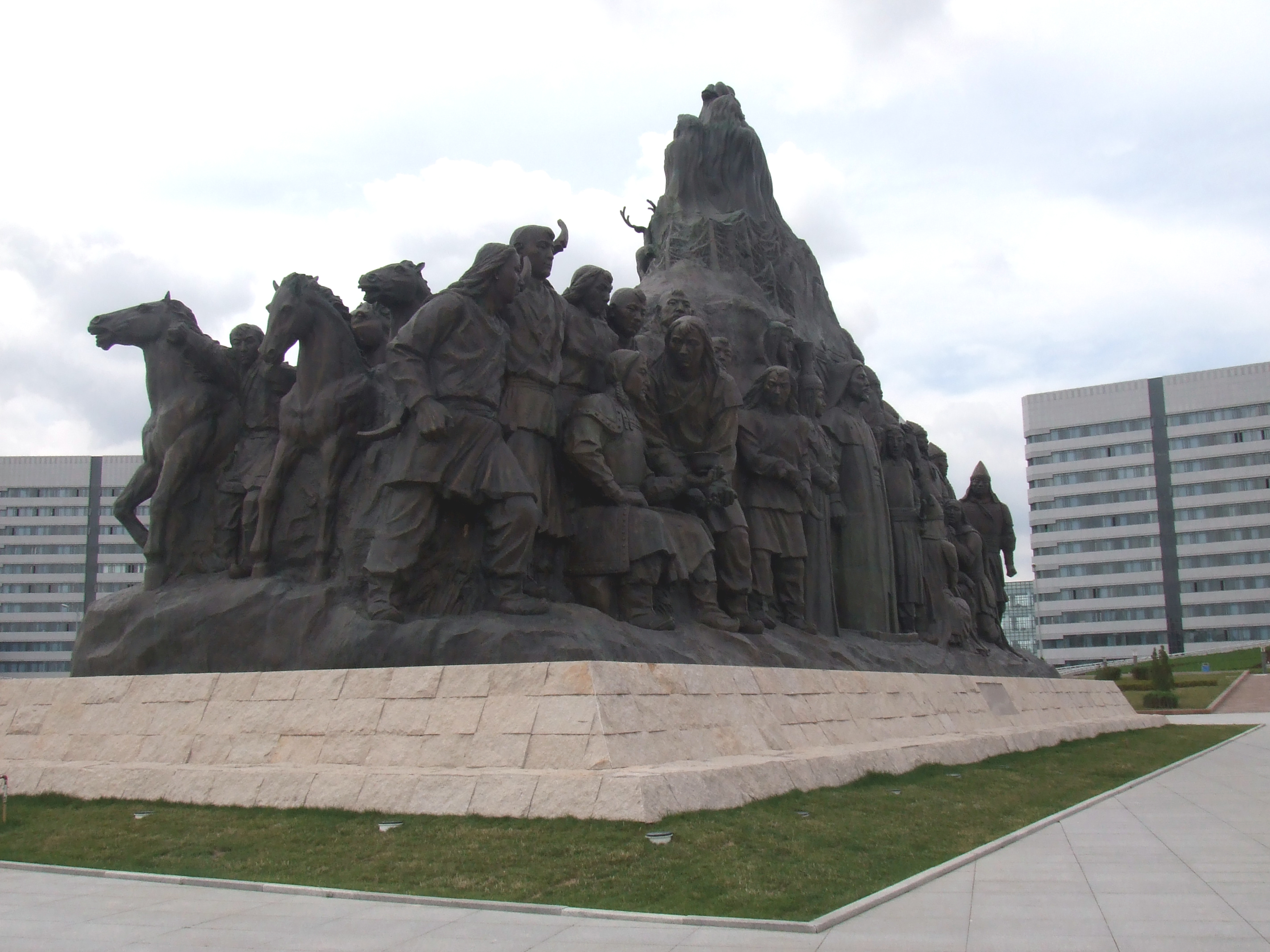
Chinese: 鄂尔多斯— Prefecture-level city — 鄂尔多斯市 Sculpture in Ordos City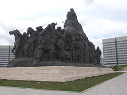 Ordos City (red) in Inner Mongolia (orange) and China
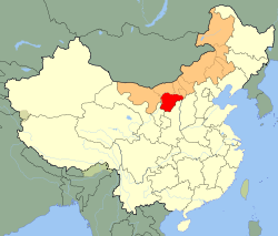 Location in Inner Mongolia
 Ordos
OrdosCoordinates: 39°36′N 109°47′E / 39.6°N 109.783°ECoordinates: 39°36′N 109°47′E / 39.6°N 109.783°E Country People's Republic of China Region Inner Mongolia City seat Dongsheng District Area - Total 87,000 km2 (33,590.9 sq mi) Elevation 1,305 m (4,281 ft) Highest elevation 2,149 m (7,051 ft) Lowest elevation 850 m (2,789 ft) Population (2009) - Total 1,548,000 - Density 17.8/km2 (46.1/sq mi) Time zone China Standard (UTC+8) GDP CNY 115.90 billion ($US 16.85 billion)[1] GDP per capita CNY 75,161 ($US 10,885) Website http://www.ordos.gov.cn/ Ordos City Chinese name Traditional Chinese 鄂爾多斯 Simplified Chinese 鄂尔多斯 Transcriptions Mandarin - Hanyu Pinyin È'ěrduōsī Mongolian name Mongolian
Ордос хотOrdos (Mongolian: Ордос,
, Ordos; Chinese: 鄂尔多斯; pinyin: È'ěrduōsī) is one of the twelve major subdivisions of Inner Mongolia, China. It is located within the Ordos Loop of the Yellow River. Although mainly rural, Ordos is administered as a prefecture-level city. The administrative seat is at Dongsheng.The area had been administered as Yekhe Juu League (Chinese: 伊克昭盟; pinyin: Yikezhao Meng) since the 17th century, and was redesignated a prefecture-level city and renamed to Ordos on 26 February 2001. "Ordos" means "palaces" in the Mongolian language;[2] the name is sometimes claimed to be related to the eight white yurts of Genghis Khan.[3] Linguistically, the Ordos dialect of Mongolian is quite different from neighboring Chakhar. Ordos is known for its lavish government projects, including the new Ordos City, a city of exquisite buildings and abundant infrastructure seldom used by residents.[4] It will be hosting 2012 Miss World Final.
Contents
Geography and climate
Ordos's prefectural administrative region occupies 86,752 square kilometres (33,495 sq mi) and covers the bigger part of the Ordos Desert, although the urban area itself is relatively small. The region borders the prefectures of Hohhot to the east, Baotou to the northeast, Bayan Nur to the north, Alxa League to the northwest, Wuhai to the west, the Ningxia Hui Autonomous Region to its southwest, and the provinces of Shaanxi and Shanxi to the south.
The area of Ordos Shi can roughly be divided into a hilly area in the east, high plateaus in the west and center, sandy deserts in the north and south, and plains at the southern bank of the Yellow river. The highest elevation, at 2,149 metres (7,051 ft), is located in the west, the lowest point, at 850 m (2,790 ft), is in the east.
There are two large deserts within the territory of Ordos Shi, namely the Kubuqi Desert (库布其沙漠) in the north, and the Maowusu Desert (毛乌素沙漠) in the south. The Kubuqi Desert occupies 19.2% of Ordos, or 16,600 km2 (6,400 sq mi), while the Maowusu Desert takes up 28.8% of the area, or 25,000 km2 (9,700 sq mi).
Ordos features a cold semi-arid climate (Köppen BSk), marked by long, cold and very dry winters, very warm, somewhat humid summers, and strong winds, especially in spring. The annual precipitation is 300 to 400 millimetres (11.8 to 15.7 in) in the eastern part of the prefecture, and 190 to 350 mm (7.5 to 13.8 in) in the western part. Most of the rain falls between July and September, with very little snow in winter.
Climate data for Ordos (1971−2000) Month Jan Feb Mar Apr May Jun Jul Aug Sep Oct Nov Dec Year Average high °C (°F) −4.8
(23.4)−1.3
(29.7)5.2
(41.4)14.1
(57.4)20.8
(69.4)25.0
(77.0)26.7
(80.1)24.5
(76.1)19.4
(66.9)12.6
(54.7)4.0
(39.2)−2.9
(26.8)11.9 Average low °C (°F) −14.7
(5.5)−11.5
(11.3)−5.4
(22.3)1.9
(35.4)8.4
(47.1)13.0
(55.4)15.8
(60.4)14.3
(57.7)8.8
(47.8)2.1
(35.8)−5.9
(21.4)−12.3
(9.9)1.2 Precipitation mm (inches) 2.1
(0.083)4.4
(0.173)10.8
(0.425)11.4
(0.449)25.8
(1.016)44.8
(1.764)105.7
(4.161)105.5
(4.154)44.7
(1.76)19.4
(0.764)5.3
(0.209)1.3
(0.051)381.2
(15.008)Avg. precipitation days (≥ 0.1 mm) 2.1 2.9 4.3 3.4 5.9 8.7 12.2 11.9 8.1 4.4 2.6 1.9 68.4 Source: Weather China Economy
Ordos is one of the richest regions of China. With a nominal per-capita GDP of US$14,500 in 2008, it is ranked ahead of the capital city of China, Beijing. It is extremely rich in natural resources, having one sixth of the coal reserve in China. The pillars of its economy are textile (wool), coal mining, petrochemicals, electricity generation and production of building materials.
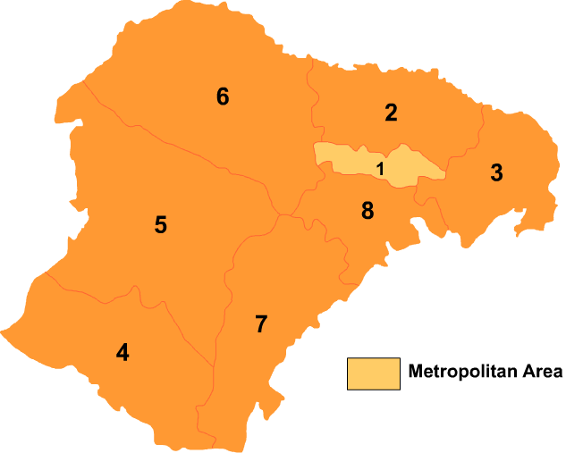
Administrative Subdivisions
Ordos Shi is divided into one district and seven banners:
Map 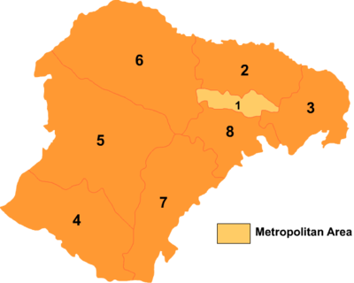
# Name Hanzi Hanyu Pinyin Population (2004 est.) Area (km²) Density (/km²) 1 Dongsheng District 东胜区 Dōngshèng Qū 230,000 2,137 108 2 Dalad Banner 达拉特旗 Dálātè Qí 330,000 8,192 40 3 Jungar Banner 准格尔旗 Zhǔngé'ěr Qí 270,000 7,535 36 4 Otog Front Banner 鄂托克前旗 Ètuōkè Qián Qí 70,000 12,318 6 5 Otog Banner 鄂托克旗 Ètuōkè Qí 90,000 20,064 4 6 Hanggin Banner 杭锦旗 Hángjǐn Qí 130,000 18,903 7 7 Uxin Banner 乌审旗 Wūshěn Qí 100,000 11,645 9 8 Ejin Horo Banner 伊金霍洛旗 Yījīnhuòluò Qí 140,000 5,958 23 Kangbashi New Area, Empty Real Estate Development
A large, and largely uninhabited urban real estate development has been constructed 25 km. from the city of Dongsheng. Intended to house a million people, it remains largely uninhabited.[5] Intended to have 300,000 residents by 2010, government figures claimed it had 28,000, which the New York Times is skeptical of.[6] It has been the subject of several well publicized articles, some profusely illustrated.[7] The Daily Mail has documented Ordos/Kangbashi and other similar urban developments in China.[8]
Demographics
In the 2000 census, there were 1,369,766 inhabitants:
ethnic group population share Han 1,207,971 88.19% Mongols 155,845 11.38% Manchu 2,905 0.21% Hui 1,861 0.14% Tibetans 1,023 0.07% See also
- Ordos culture
- Ordos International Circuit
- New South China Mall and Chenggong, examples of other underused developments
- List of cities in the People's Republic of China by population
- List of cities in the People's Republic of China by GDP per capita
References
- ^ [1]
- ^ http://www.ordos.gov.cn/zjeedx/sqgk/ 市情概况
- ^ W. R. Carles, "Problems in Exploration II. Ordos", in The Geographical Journal, Vol. 33, No. 6 (Jun., 1909)", p. 669
- ^ Al-Jazeera (2009-11-09). "China's Empty City" (video). YouTube. http://www.youtube.com/watch?v=0h7V3Twb-Qk.
- ^ Time Photos of Ordos/Kangbashi, Time Photos Website 2011
- ^ http://www.nytimes.com/2010/10/20/business/global/20ghost.html?pagewanted=all
- ^ "China's Ghost Town". AlJazeera. 10 November 2009. http://www.youtube.com/watch?v=0h7V3Twb-Qk. Retrieved 2010-12-21.
- ^ The Ghost Towns of China...The Daily Telegraph 18 Dec 2010
External links
Inner Mongolia topics Hohhot (capital) General Geography Education Culture Music of Mongolia • Mongolian language • Mongolian script • Northeastern Mandarin • Plain Blue BannerCuisine Visitor attractions Inner Mongolia Autonomous Region county-level divisions Hohhot (capital) Hohhot: Huimin District · Xincheng District · Yuquan District · Saihan District · Togtoh County · Wuchuan County · Horinger County · Qingshuihe County · Tumed Left Banner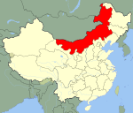 Inner Mongolia in China
Baotou: Kundulun District · Donghe District · Qingshan District · Shiguai District · Baiyun Mining District · Jiuyuan District · Guyang County · Tumed Right Banner · Darhan Muminggan United Banner
Wuhai: Haibowan District · Hainan District · Wuda District
Chifeng: Hongshan District · Yuanbaoshan District · Songshan District · Ningcheng County · Linxi County · Ar Horqin Banner · Bairin Left Banner · Bairin Right Banner · Hexigten Banner · Ongniud Banner · Harqin Banner · Aohan Banner
Tongliao: Horqin District · Huolin Gol City · Kailu County · Hure Banner · Naiman Banner · Jarud Banner · Horqin Left Middle Banner · Horqin Left Back Banner
Ordos: Dongsheng District · Dalad Banner · Jungar Banner · Otog Front Banner · Otog Banner · Hanggin Banner · Kangbashi · Uxin Banner · Ejin Horo Banner
Hulunbuir: Hailar District · Manzhouli City · Zalantun City · Yakeshi City · Genhe City · Ergun City · Arun Banner · New Barag Right Banner · New Barag Left Banner · Old Barag Banner · Oroqin (Autonomous) · Evenk (Autonomous) · Morin Dawa Daur (Autonomous)
Bayan Nur: Linhe District · Wuyuan County · Dengkou County · Urat Front Banner · Urat Middle Banner · Urat Rear Banner · Hanggin Rear Banner
Ulanqab: Jining District · Fengzhen City · Zhuozi County · Huade County · Shangdu County · Xinghe County · Liangcheng County · Chahar Right Front Banner · Chahar Right Middle Banner · Chahar Right Back Banner · Siziwang Banner
Xilin Gol: Xilinhot City · Erenhot City · Duolun County · Abag Banner · Sonid Left Banner · Sonid Right Banner · East Ujimqin Banner · West Ujimqin Banner · Taibus Banner · Bordered Yellow Banner · Plain and Bordered White Banner · Plain Blue Banner
Hinggan: Ulan Hot City · Arxan City · Tuquan County · Horqin Right Front Banner · Horqin Right Middle Banner · Jalaid Banner
Alxa: Alxa Left Banner · Alxa Right Banner · Ejin Banner■ = Prefecture-level city ■ = League
See also: List of Inner Mongolia County-level divisionsMajor cities along the Yellow River Provinces and Autonomous regions Cities(from upper reaches to lower reaches)
Gansu Ningxia Inner Mongolia Shanxi Shaanxi Henan Shandong Categories:- Cities in Inner Mongolia


Wikimedia Foundation. 2010.