- Manzhouli
-
Manzhouli
满洲里— Sub-prefecture-level city — 满洲里市 Manzhouli Center Location in China
 Manzhouli
Coordinates: 49°36′N 117°26′E / 49.6°N 117.433°ECoordinates: 49°36′N 117°26′E / 49.6°N 117.433°E Country China Region Inner Mongolia Prefecture Hulunbuir Area – Total 696.3 km2 (268.8 sq mi) Population – Total 300,000 – Density 430.8/km2 (1,115.9/sq mi) Time zone China Standard (UTC+8) Postal code 021400 Area code(s) 0470 Website http://www.manzhouli.gov.cn/ Manzhouli (simplified Chinese: 满洲里; traditional Chinese: 滿洲里; pinyin: Mǎnzhōulǐ; Mongolian: Манжуур / Manǰuur, Russian: Маньчжу́рия / Маньчжоули́) is a sub-prefecture-level city located in Hulunbuir prefecture-level city, Inner Mongolia Autonomous Region of the People's Republic of China (PRC). It is the PRC's busiest land port of entry. It has an area of 696.3 square kilometres (268.8 sq mi) and a population of more than 300,000 (in 2010).
Contents
Geography
Manzhouli is located in the western part of the Hulunbuir prefecture-level city. To the east, south and west it borders New Barghu Left Banner and New Barghu Right Banner, also in Hulunbuir, and Russia to the north, with which it shares a border 54 kilometres (34 mi) long. The Russian townlet of Zabaykalsk is situated immediately north of Abagaitu Islet and Manzhouli.
Manzhouli is located on the Hulunbuir grasslands. Lake Hulun to its immediate south is the PRC's fifth largest freshwater lake with an area of 2,600 square kilometres (1,000 sq mi) and an average depth of just 5 metres (16 ft).
Climate
Climate data for Manzhouli Month Jan Feb Mar Apr May Jun Jul Aug Sep Oct Nov Dec Year Average high °C (°F) −19
(−2)−14
(7)−4
(25)9
(48)18
(64)24
(75)26
(79)23
(73)17
(63)7
(45)−6
(21)−16
(3)5.4
(41.8)Average low °C (°F) −31
(−24)−29
(−20)−19
(−2)−6
(21)2
(36)10
(50)14
(57)11
(52)3
(37)−6
(21)−19
(−2)−28
(−18)−8.2
(17.3)Rainfall mm (inches) 1
(0.04)2
(0.08)3
(0.12)11
(0.43)20
(0.79)54
(2.13)108
(4.25)75
(2.95)36
(1.42)6
(0.24)2
(0.08)2
(0.08)320
(12.6)Avg. rainy days 4 4 4 5 7 11 15 13 9 5 5 6 88 Sunshine hours 186 196 248 270 279 300 279 279 240 217 180 155 2,829 Source: World Climate Guide Administration
Manzhouli is divided into ten subdistricts and one town. Six of the subdistricts of Manzhouli are grouped into a district. Technically however, only a prefecture-level city (half a level higher than Manzhouli) can have districts, so Manzhouli's lone district is not officially listed.
History
In ancient times the area was inhabited by many tribes that lived in Manchuria, including the Donghu, the Xiongnu, the Xianbei, the Khitan, the Jurchen, and the Mongols. From the early Qing Dynasty onwards the Argun River, which originates in this area, became the border between the China and Russia.
In 1901, the China Far East Railway was completed in accordance with the Sino-Russian Secret Treaty of 1896, linking Siberia, Manchuria, and the Russian Far East. A settlement then formed around Manchzhuriya Station, the first stop within Manchuria for Russians. It was the beginning of the modern city of Manzhouli and the name of Manzhouli came from Russian Manchzhuriya (Маньчжурия i.e. Manchuria).
In 1905, Manzhouli was designated a trading center in the Sino-Japanese Treaty of 1905, greatly boosting Manzhouli's growth. In 1908 the Manzhouli customs was set up. Under the Republic of China, Manzhouli came under the jurisdiction of the province of Hsingan. In 1927, Manzhouli was designated as a city. Although with Hsingan and surrounding areas, Manzhouli came under Japanese control in 1931, and was part of the Empire of Manchukuo from 1932-1945. It became part of Inner Mongolia under the People's Republic of China from 1946.
In 1992, Manzhouli became one of the first land border cities opened up by the People's Republic of China. It has since experienced somewhat of a boom as a center of border trade between China and Russia.[1]
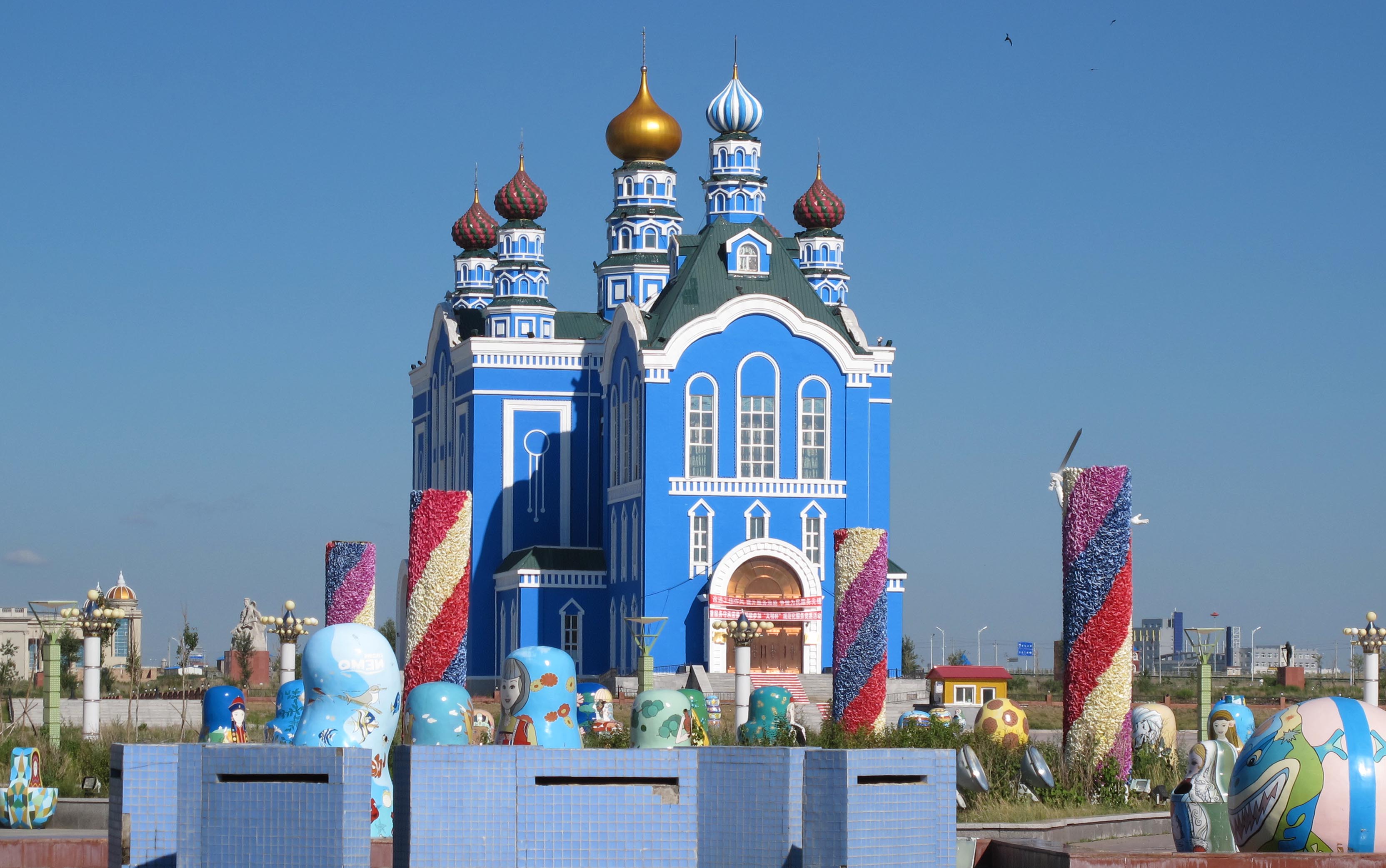
 Matryoshka Square
Culture
Manzhouli Ice & Snow Festival takes place every winter from some time in February to early March. This is a smaller version of Harbin's Ice and Snow Festivals.
Economy
Manzhouli is China's busiest land port of entry, and is responsible for 60% of all imports from and exports to Eastern Europe.
Demographics
95% of Manzhouli's population is Han Chinese. The remainder are Mongol, Manchu, or of other ethnicities.
Transportation
Railway
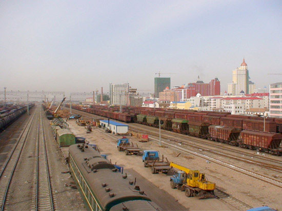
 Trains being loaded and unloaded just south of the Russian border. The Chinese 1,435 mm (4 ft 8 1⁄2 in) gauge changes here to the Russian 1,524 mm (5 ft) .
Trains from Beijing to Moscow on the Trans-Manchurian branch of the Trans-Siberian Railway pass through here. There are also tourist lines to Chita, Krasnokamensk, Irkutsk, and Ulan Ude.
A break of gauge multi-modal transshipment facility is being completed in 2008 across the Russian border in Zabaikalsk.
Air
Manzhouli Airport is located in the western part of the city. Passengers can fly to Beijing and the Inner Mongolia's capital city Hohhot from the airport.
Highway
- By China National Highway 301 linked to Inner Mongolia and Heilongjiang cities.
Sister cities
Manzhouli is twinned with the following sister cities.[2]
City State Country Chita  Zabaykalsky Krai
 Russia
Krasnokamensk Zabaykalsky Krai RussiaUlan-Ude  Buryatia Russia
References
- ^ Siberia's black market logging (BBC News, 2008-04-09)
- ^ Sister cities
External links
- Manzhouli : Where the Clock Always Strikes Nine Manzhouli: Photos and observations
- Manzhouli : City of the Plain Pictures and Stories of a trip to Manzhouli at www.pocopico.com
- Official Site (Simplified Chinese)
- Information Portal (Simplified Chinese)
- St. Jonah of Manchuria (Russian Orthodox Saint who lived and died in Manzhouli)
- Post codes of Inner Mongolia (English)
Inner Mongolia Autonomous Region county-level divisions Hohhot: Huimin District · Xincheng District · Yuquan District · Saihan District · Togtoh County · Wuchuan County · Horinger County · Qingshuihe County · Tumed Left Banner Inner Mongolia in China
Baotou: Kundulun District · Donghe District · Qingshan District · Shiguai District · Baiyun Mining District · Jiuyuan District · Guyang County · Tumed Right Banner · Darhan Muminggan United Banner
Wuhai: Haibowan District · Hainan District · Wuda District
Chifeng: Hongshan District · Yuanbaoshan District · Songshan District · Ningcheng County · Linxi County · Ar Horqin Banner · Bairin Left Banner · Bairin Right Banner · Hexigten Banner · Ongniud Banner · Harqin Banner · Aohan Banner
Tongliao: Horqin District · Huolin Gol City · Kailu County · Hure Banner · Naiman Banner · Jarud Banner · Horqin Left Middle Banner · Horqin Left Back Banner
Ordos: Dongsheng District · Dalad Banner · Jungar Banner · Otog Front Banner · Otog Banner · Hanggin Banner · Kangbashi · Uxin Banner · Ejin Horo Banner
Hulunbuir: Hailar District · Manzhouli City · Zalantun City · Yakeshi City · Genhe City · Ergun City · Arun Banner · New Barag Right Banner · New Barag Left Banner · Old Barag Banner · Oroqin (Autonomous) · Evenk (Autonomous) · Morin Dawa Daur (Autonomous)
Bayan Nur: Linhe District · Wuyuan County · Dengkou County · Urat Front Banner · Urat Middle Banner · Urat Rear Banner · Hanggin Rear Banner
Ulanqab: Jining District · Fengzhen City · Zhuozi County · Huade County · Shangdu County · Xinghe County · Liangcheng County · Chahar Right Front Banner · Chahar Right Middle Banner · Chahar Right Back Banner · Siziwang Banner
Xilin Gol: Xilinhot City · Erenhot City · Duolun County · Abag Banner · Sonid Left Banner · Sonid Right Banner · East Ujimqin Banner · West Ujimqin Banner · Taibus Banner · Bordered Yellow Banner · Plain and Bordered White Banner · Plain Blue Banner
Hinggan: Ulan Hot City · Arxan City · Tuquan County · Horqin Right Front Banner · Horqin Right Middle Banner · Jalaid Banner
Alxa: Alxa Left Banner · Alxa Right Banner · Ejin BannerChina–Russia border crossings Categories:- Cities in Inner Mongolia
- China–Russia border crossings


Wikimedia Foundation. 2010.