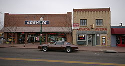
- Arvada Downtown
-
Arvada Downtown

Location: Arvada, Colorado Coordinates: 39°48′03″N 105°04′48″W / 39.8009°N 105.0801°WCoordinates: 39°48′03″N 105°04′48″W / 39.8009°N 105.0801°W Architect: Harry James Manning Architectural style: Early Commercial, Queen Anne, Modern NRHP Reference#: 98000854 Added to NRHP: July 15, 1998 Arvada Downtown, also known as Olde Town Arvada (5JF1278), is a historic district in Arvada, Colorado bounded by Ralston Road, Teller Road, Grandview Avenue and Yukon Street. It was listed on the National Register of Historic Places in 1998.
See also
U.S. National Register of Historic Places Topics Lists by states Alabama • Alaska • Arizona • Arkansas • California • Colorado • Connecticut • Delaware • Florida • Georgia • Hawaii • Idaho • Illinois • Indiana • Iowa • Kansas • Kentucky • Louisiana • Maine • Maryland • Massachusetts • Michigan • Minnesota • Mississippi • Missouri • Montana • Nebraska • Nevada • New Hampshire • New Jersey • New Mexico • New York • North Carolina • North Dakota • Ohio • Oklahoma • Oregon • Pennsylvania • Rhode Island • South Carolina • South Dakota • Tennessee • Texas • Utah • Vermont • Virginia • Washington • West Virginia • Wisconsin • WyomingLists by territories Lists by associated states Other  Category:National Register of Historic Places •
  Portal:National Register of Historic PlacesCategories:
- Historic districts in Colorado
- Arvada, Colorado
- Neighborhoods in Colorado
- National Register of Historic Places in Colorado
Wikimedia Foundation. 2010.

