- Newhaven, Edinburgh
-
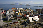
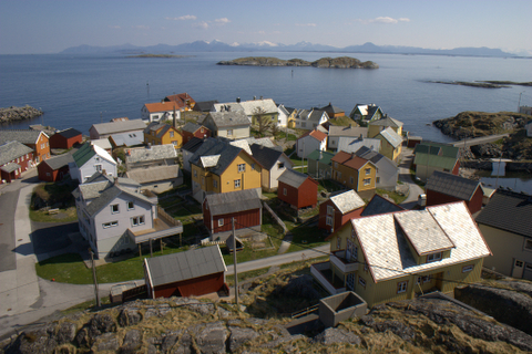
 Newhaven harbour in overcast sunlight
Newhaven is a district in the City of Edinburgh, Scotland, between Leith and Granton. Formerly a village and harbour on the Firth of Forth, it currently has approximately 5,000 inhabitants.
Newhaven is a conservation area, about 2 miles (3.2 km) north of the city centre. Newhaven is one of 40 Conservation Areas in Edinburgh. The Newhaven Conservation Area was designated in 1977.[1]
It has a very distinctive building form, typical of many Scottish fishing villages, with a 'forestair' leading to accommodation at first floor level. The lower ground floor was used for storing nets.
Victoria Primary School, established in the 1850s, is a historic building in Newhaven Main Street, and is the oldest local authority Primary School still in use within in the City of Edinburgh. It has a school roll of around 145 children.
The new Western Harbour development extends north into the Firth of Forth from Newhaven. It is also the home of Next Generation Sports Centre (now named David Lloyd Newhaven Harbour), where the tennis player Andy Murray regularly played as a youngster.
Contents
History

 'His Faither's Breeks', a Newhaven boy, by Robert Adamson and David Octavius Hill, 1843-1847; from the collection of the National Galleries of Scotland
The village lies at the line of a prehistoric raised beach.
It was part of the North Leith Parish being North of the river. It was once a thriving fishing village and a centre for shipbuilding. King James IV had wanted to build a Scottish navy, but the existing port of Leith had proved unsuitable for large warships. In 1504 he created Newhaven (literally meaning new harbour) as a custom-built port, specifically to build the warship Michael (popularly called the "Great Michael"). The ship was built between 1507 and 1511. The site of the original harbour is the current open space at Fishmarket Square.
Many of the founding families came from across the North Sea bringing their shipbuilding and rope making skills and customs and dress with them. As a result the town was well documented in photographs with many of the earliest photos being taken of the people in the area.[2]
The Society of Free Fishermen of Newhaven dates from at least 1572 and was one of the oldest friendly societies in Scotland.[3] It survived until 1989. Many of the Forth shipping pilot boats were based here.
The village was once connected by the Edinburgh, Leith and Newhaven Railway to Edinburgh and Leith, but it was shut down in 1956.
Between 1572 and 1890, Newhaven was a major oyster port. It also played a role in the whaling industry, marked by the name "Whale Brae" at the northmost end of Newhaven Road. A lighthouse was built on the harbour wall in 1869. Newhaven's harbour is now dwarfed by the enlarged Leith Harbour. The once thriving Victorian Fishmarket is now converted into a smaller fishmarket (still in use), and a Loch Fyne restaurant. The Newhaven Heritage Museum which used to occupy a small section of the old fishmarket closed in 2007. It is to be converted to a retail fishmonger, linked to the adjacent fishmarket.
The village also played its part in the birth of photography. David Octavius Hill and Robert Adamson did many studies of the fishwives of Newhaven.
Newhaven was redeveloped by Edinburgh's planners in the 1950s and 1960s under the control of both the city architect (for the demolition elements) and Ian Lindsay and Partners (for the reconstruction). The Main Street was almost wholly obliterated but rebuilt in replica on its north side. The south side was rebuilt as three storey flats in a typically bland 1960s style. Other redevelopment in the area, at Great Michael Rise and on Laverockbank Crescent, was by eminent Scottish modern architect Sir Basil Spence.
A 16th century armorial panel on the south side of the main street appears to come from Trinity Mains Farm, a farm estate linked to Trinity House in Leith, bearing the same crest as that building. The farm gave its name to the adjacent suburb of Trinity. The panel is copied in part on a plaque on the local primary school.
The upper section of the village contained larger villas, looking down over the more crowded village of fishing cottages. Park Road holds the original whalemasters house (no.13) looking down onto the harbour below.
Notable inhabitants
Jimmy Campbell also played for the Scottish football team in the late 19th century
Tennis player Andy Murray trained here.
Glasgow musician Tony Donaldson has a house in Newhaven.
Transport
Newhaven is served by several buses: 7 and 11 going direct to the city centre, 16 linking to Leith and from there again to the city centre.
Newhaven was part of the early 20th century tram route until 1956.
A new tramstop for the area, Newhaven tram stop, was proposed to serve the area as part of Edinburgh Trams. This section is no longer on the primary route for completion in the first phase.
Notes
References
- Newhaven: A Fishing Village ElectricScotland.com. Retrieved 20 April 2009.
External links
Coordinates: 55°58′46.29″N 3°11′35.54″W / 55.979525°N 3.1932056°W
History of fishing History - History of fishing
- Traditional fishing boats
- Chasse-marée
- Cornwall
- Scottish east coast fishery
- Garum
- Ancient Hawaiian aquaculture
- Migratory Fishery of Labrador
- Munster pilchard fishery 1570-1750
- Fishery Protection Squadron
- Cod-fishing in the North atlantic
- Pearling in WA
- Scania Market
- Harold Innis and the cod fishery
- Fishing stage
Conflicts Disasters Historic fishing villages and communities Fishing villages - Akwidaa
- Algajola
- Ardglass
- Bethsaida
- Bolungarvík
- Cadgwith
- Catalan Bay
- Clovelly
- Cullercoats
- Dunmore East
- Findon
- Gilleleje
- Grip
- Gümüşlük
- Hovden
- Huanchaco
- Kaunolu Village
- Ladner
- Lamorna
- Marsaxlokk
- Moskenes
- Newhaven
- Nyksund
- Old Perlican
- Ona
- Peggys Cove
- Pittenweem
- Po Toi O
- Polperro
- Port Isaac
- Portmahomack
- Portavogie
- Portofino
- St. Abbs
- Red Bay
- Reine
- Saint Malo
- Sa Riera
- Sayulita
- Sigri
- Staithes
- Steveston
- Súðavík
- Suðureyri
- Tai O
- Tilting
- Udappu
- Vernazza
- Walraversijde
- more...
Communities - Fishing
- Index of fishing articles
- List of fishing topics by subject
- Fisheries glossary
Categories:- Ports and harbours of Scotland
- Fishing villages


Wikimedia Foundation. 2010.