- Dalmeny
-
For other uses, see Dalmeny (disambiguation).
Coordinates: 55°58′59″N 3°22′12″W / 55.983°N 3.370°W
Dalmeny Scottish Gaelic: Dail Mheinidh, Dail M'Eithne 
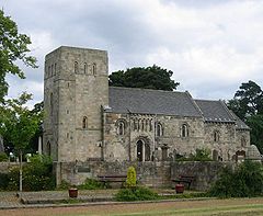
Dalmeny Kirk, one of the finest Norman churches in Scotland
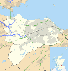
 Dalmeny shown within Edinburgh
Population 9,867 (2001) OS grid reference NT1477 Parish Dalmeny Council area Edinburgh Lieutenancy area Edinburgh Country Scotland Sovereign state United Kingdom Post town EDINBURGH Postcode district EH30 Dialling code 0131 Police Lothian and Borders Fire Lothian and Borders Ambulance Scottish EU Parliament Scotland List of places: UK • Scotland • Edinburgh Dalmeny (Scottish Gaelic: Dail Mheinidh) is a suburban village and civil parish in Edinburgh, Scotland. It is located on the south side of the Firth of Forth, 1 mile (1.6 km) east-southeast of South Queensferry and 8.3. miles (13.4 km) west-northwest of central Edinburgh; it falls under the local governance of the City of Edinburgh Council.
The name Dalmeny is either of Cumbric origin Din Meini "stony fort" cf. the earlier form Dunmanye (1562)[1], most likely referring to Castle Craig above the town, or potentially of Scottish Gaelic origin, being now Dail Mheinnidh or Dail M'Eithne in the modern language. This may refer to an ancient ecclesiastical settlement, dedicated to an obscure (female) saint Eithne; the local parish church may have been dedicated to her, but is now dedicated to St Cuthbert. It is at least a thousand years old.
The present church building is recognised as the finest Norman/Romanesque parish church still in use in Scotland, and one of the most complete in the United Kingdom, lacking only its original western tower (rebuilt in a sympathetic style in 1937[2]). The aisleless nave, choir and apse survive almost complete from the 12th century. The refined sculptural detail of the chancel and apse arches is notable, as is a series of powerful beast-head corbels supporting the apse vault. These features are also extremely well preserved, with the original tool-marks still visible. Outside the elaborate south doorway, including the signs of the zodiac and an "agnus dei", enlivened with blind arcading above, is a rare 12th century sarcophagus carved with 13 doll-like figures (possibly Christ and the 12 apostles) in niches (now very weathered). The door is comparable to the north door at Dunfermline Abbey[3]
The north (Rosebery) aisle dates from 1671 and was remodelled in the late 19th century. This has elaborate but "inaccurate" Neo-Norman details[4].
When viewed from a distance the church appears to rise on a mound above the local topography. It is speculated that it is built on a pre-Christian burial mound[5]. This would mean that the graveyard predates the church. A second detached mound of smaller size lies on the east road out of the village.
Apart from its parish church, Dalmeny is best known for the stately home, Dalmeny House. The south end of the Forth Bridge begins in Dalmeny, and this is the location for the railway station for South Queensferry. The village, , consisting mainly of 20th century housing, has no buildings of historic interest except for its exceptionally fine church (where John Hill Burton is interred).
The late 1990s have seen a large amount of new housing, mainly for Edinburgh commuters.
Dalmeny, along with Queensferry, Kirkliston, Cramond, Silverknowes, Newbridge, Gogar and Cammo, forms the Almond electoral ward.
References
- ^ Watson, W. (1926) A History of Celtic Place-names of Scotland". Edinburgh
- ^ Buildings of Scotland:Lothian, by Colin McWilliam
- ^ Buildings of Scotland:Lothian, by Colin McWilliam
- ^ Buildings of Scotland:Lothian, by Colin McWilliam
- ^ Stephen C Dickson; investigation on pre-christian influences on christian architecture
Categories:- Areas of Edinburgh
- Villages in Edinburgh council area
Wikimedia Foundation. 2010.


