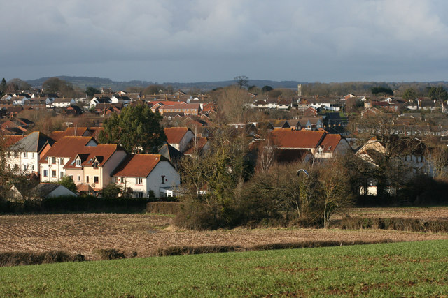
- Comeytrowe
-
Coordinates: 51°00′19″N 3°08′04″W / 51.0053°N 3.1344°W
Comeytrowe 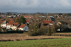
Comeytrowe
 Comeytrowe
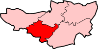
Comeytrowe shown within SomersetPopulation 5,780 [1] OS grid reference ST205235 District Taunton Deane Shire county Somerset Region South West Country England Sovereign state United Kingdom Post town TAUNTON Postcode district TA1 Dialling code 01823 Police Avon and Somerset Fire Devon and Somerset Ambulance South Western EU Parliament South West England UK Parliament Taunton Deane List of places: UK • England • Somerset Comeytrowe is a civil parish in Somerset, England, situated in the south western suburbs of Taunton in the Taunton Deane district. The parish has a population of 5,780.[1] The parish includes the area of Galmington.
Contents
History
The suburb of Comeytrowe was built in the second half of the 20th century to house the growing population of Taunton.[2]
The parish was formed in 1986 occupying land which was previously part of the parish of Trull.[2]
In the 1980s new shops and a doctors' surgery were opened. A new parish church dedicated to St Michael was also constructed.[2]
Governance
The parish council has responsibility for local issues, including setting an annual precept (local rate) to cover the council’s operating costs and producing annual accounts for public scrutiny. The parish council evaluates local planning applications and works with the local police, district council officers, and neighbourhood watch groups on matters of crime, security, and traffic. The parish council's role also includes initiating projects for the maintenance and repair of parish facilities, as well as consulting with the district council on the maintenance, repair, and improvement of highways, drainage, footpaths, public transport, and street cleaning. Conservation matters (including trees and listed buildings) and environmental issues are also the responsibility of the council.
The village falls within the Non-metropolitan district of Taunton Deane, which was formed on April 1, 1974 under the Local Government Act 1972, having previously been part of Taunton Municipal Borough[3] and Taunton Rural District.[4] The district council is responsible for local planning and building control, local roads, council housing, environmental health, markets and fairs, refuse collection and recycling, cemeteries and crematoria, leisure services, parks, and tourism.
Somerset County Council is responsible for running the largest and most expensive local services such as education, social services, libraries, main roads, public transport, policing and fire services, trading standards, waste disposal and strategic planning.
It is also part of the Taunton Deane county constituency represented in the House of Commons of the Parliament of the United Kingdom. It elects one Member of Parliament (MP) by the first past the post system of election, and part of the South West England constituency of the European Parliament which elects seven MEPs using the d'Hondt method of party-list proportional representation.
Geography
The South Taunton Streams Local Nature Reserve was created in 2004.[5] It includes four sites: Mill Stream, Killams, Glasses Mead and Blackbrook Open Space which provide a wetland environment in the suburbs of south Taunton before reaching the River Tone.
The flora and fauna include Water voles, Otters, Kingfishers, Sand martins and Dippers. They are also foraging areas for bats, especially Pipistrelle, Lesser horseshoe and Noctule.[6]
Climate
Along with the rest of South West England, Comeytrowe has a temperate climate which is generally wetter and milder than the rest of the country.[7] The annual mean temperature is approximately 10 °C (50.0 °F). Seasonal temperature variation is less extreme than most of the United Kingdom because of the adjacent sea temperatures. The summer months of July and August are the warmest with mean daily maxima of approximately 21 °C (69.8 °F). In winter mean minimum temperatures of 1 °C (33.8 °F) or 2 °C (35.6 °F) are common.[7] In the summer the Azores high pressure affects the south-west of England, however convective cloud sometimes forms inland, reducing the number of hours of sunshine. Annual sunshine rates are slightly less than the regional average of 1,600 hours.[7] In December 1998 there were 20 days without sun recorded at Yeovilton. Most the rainfall in the south-west is caused by Atlantic depressions or by convection. Most of the rainfall in autumn and winter is caused by the Atlantic depressions, which is when they are most active. In summer, a large proportion of the rainfall is caused by sun heating the ground leading to convection and to showers and thunderstorms. Average rainfall is around 700 mm (28 in). About 8–15 days of snowfall is typical. November to March have the highest mean wind speeds, and June to August have the lightest winds. The predominant wind direction is from the south-west.[7]
Education
The Bishop Henderson primary school, named after the then Bishop of Bath and Wells, was built in the 1980s and provides places for 400 pupils aged 4 to 11. Secondary education is provided at The Castle School, which shares its campus with the Somerset College of Arts and Technology. Private education is available at Queen's College.
Sports
Galmington is home to a youth football club called Galmington Dragons who play at Musgrove Park in the Taunton Youth League. The teams start playing at the park from eleven and up.[8]
References
- ^ a b "Taunton Deane 2002 parish population estimates". Somerset County Council. http://www.webcitation.org/5lRyCZwqu. Retrieved 27 December 2009.
- ^ a b c "Comeytrowe". Comeytrowe Parish Council. http://www.visionwebsites.co.uk/Contents/Text/Index.asp?SiteId=324&SiteExtra=19315356&TopNavId=700&NavSideId=3616. Retrieved 2009-02-18.
- ^ A Vision of Britain Through Time : Taunton Municipal Borough
- ^ A Vision of Britain Through Time : Taunton Rural District
- ^ "South Taunton Streams". Natural England. http://www.lnr.naturalengland.org.uk/special/lnr/lnr_details.asp?themeid=1082977. Retrieved 29 August 2010.
- ^ "South Taunton Streams". Taunton Deane Borough Council. http://www.tauntondeane.gov.uk/irj/public/services/directory/location?rid=/wpccontent/Sites/TDBC/Web%20Pages/Services/Locations/South%20Taunton%20Streams. Retrieved 29 August 2010.
- ^ a b c d "South West England: climate". Met Office. http://www.metoffice.gov.uk/climate/uk/sw/. Retrieved 14 March 2010.
- ^ "Galmington Dragons YFC". Galmington Dragons. Galmington Dragons. http://www.galmingtondragons.net. Retrieved 2010-10-02.
External links
Towns, villages and hamlets in the Taunton Deane borough of Somerset, England  Ashbrittle · Ash Priors · Bathealton · Bickenhall · Bishop's Hull · Bishops Lydeard · Bradford on Tone · Burrowbridge · Cheddon Fitzpaine · Chipstable · Churchstanton · Combe Florey · Comeytrowe · Corfe · Cotford St Luke · Cothelstone · Creech St Michael · Curland · Durston · Fitzhead · Halse · Hatch Beauchamp · Kingston St Mary · Langford Budville · Lydeard St Lawrence · Milverton · North Curry · Norton Fitzwarren · Nynehead · Oake · Orchard Portman · Otterford · Pitminster · Ruishton · Sampford Arundel · Staple Fitzpaine · Stawley · Stoke St Gregory · Stoke St Mary · Taunton · Thornfalcon · Tolland · Trull · Wellington · Wellington Without · West Bagborough · West Buckland · West Hatch · West Monkton · WiveliscombeCategories:
- Villages in Taunton Deane
- Civil parishes in Somerset

Wikimedia Foundation. 2010.