- Durston
-
Coordinates: 51°03′05″N 3°00′26″W / 51.0515°N 3.0071°W
Durston 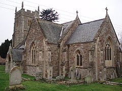
Church of St John, Durston
 Durston
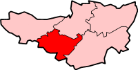
Durston shown within SomersetPopulation 141 [1] OS grid reference ST295285 District Taunton Deane Shire county Somerset Region South West Country England Sovereign state United Kingdom Post town TAUNTON Postcode district TA7 Dialling code 01823 Police Avon and Somerset Fire Devon and Somerset Ambulance South Western EU Parliament South West England UK Parliament Taunton Deane List of places: UK • England • Somerset Durston is a village and civil parish in Somerset, England, situated on the A361 road 5 miles (8.0 km) north east of Taunton and 6 miles (9.7 km) south of Bridgwater in the Taunton Deane district. The parish lies on undulating ground between the lowest slopes of the Quantock Hills and the valley of the River Tone at the Curry and Hay Moors. The village has a population of 141.[1]
Contents
History
The name of the village means Deor's settlement.[2]
After the Norman Conquest the manor was held by Roger Arundel but later passed to William de Arlegh who founded the priory of Buckland Sororum (also known as Buckland Priory) in about 1167.[2] The priory was later suppressed, and the estates given to the Knights Hospitallers. Subsequently there was a priory of Canonesses of St. Augustine, and a preceptory of Knights Hospitallers. The site is now occupied by Buckland Farm.[3]
Lodge Farmhouse dates from the 15th century and may once have been an ecclesiastical residence. It has been designated as a grade II* listed building.[4]
Governance
The parish council has responsibility for local issues, including setting an annual precept (local rate) to cover the council’s operating costs and producing annual accounts for public scrutiny. The parish council evaluates local planning applications and works with the local police, district council officers, and neighbourhood watch groups on matters of crime, security, and traffic. The parish council's role also includes initiating projects for the maintenance and repair of parish facilities, as well as consulting with the district council on the maintenance, repair, and improvement of highways, drainage, footpaths, public transport, and street cleaning. Conservation matters (including trees and listed buildings) and environmental issues are also the responsibility of the council.
The village falls within the Non-metropolitan district of Taunton Deane, which was formed on April 1, 1974 under the Local Government Act 1972, having previously been part of Taunton Rural District.[5] The district council is responsible for local planning and building control, local roads, council housing, environmental health, markets and fairs, refuse collection and recycling, cemeteries and crematoria, leisure services, parks, and tourism.
Somerset County Council is responsible for running the largest and most expensive local services such as education, social services, libraries, main roads, public transport, policing and fire services, trading standards, waste disposal and strategic planning.
It is also part of the Taunton Deane county constituency represented in the House of Commons of the Parliament of the United Kingdom. It elects one Member of Parliament (MP) by the first past the post system of election, and part of the South West England constituency of the European Parliament which elects seven MEPs using the d'Hondt method of party-list proportional representation.
Transport
The Bristol and Exeter Railway opened a Yeovil Branch Line on 1 October 1853 from a new junction station at Durston. The branch closed on 6 July 1964, with Durston station remaining open only until 5 October 1964. It is located close to Cogload Junction, a vital railway flyover.
The Bridgwater and Taunton Canal also ran though the village, when it opened in 1827. It is crossed by two bridges, Headworthy and Swan's Neck.
Religious sites
The parish Church of St John was rebuilt in 1853 on the site of an earlier church.[6]
References
- ^ a b "Taunton Deane 2002 parish population estimates". Somerset County Council. http://www.webcitation.org/5lRyCZwqu. Retrieved 27 December 2009.
- ^ a b Bush, Robin (1994). Somerset: The Complete Guide. Dovecote Press. pp. 90–91. ISBN 1874336261.
- ^ Dunning, Robert; C R Elrington, A P Baggs, M C Siraut. "Durston". Victoria County History. British History Online. http://www.british-history.ac.uk/report.aspx?compid=18668. Retrieved 2009-01-08.
- ^ "Lodge Farmhouse". Images of England. English Heritage. http://www.imagesofengland.org.uk/Details/Default.aspx?id=270606. Retrieved 2009-01-08.
- ^ A Vision of Britain Through Time : Taunton Rural District
- ^ "Church of St John". Images of England. English Heritage. http://www.imagesofengland.org.uk/Details/Default.aspx?id=270603. Retrieved 2009-01-08.
External links
 Media related to Durston at Wikimedia Commons
Towns, villages and hamlets in the Taunton Deane borough of Somerset, England  Ashbrittle · Ash Priors · Bathealton · Bickenhall · Bishop's Hull · Bishops Lydeard · Bradford on Tone · Burrowbridge · Cheddon Fitzpaine · Chipstable · Churchstanton · Combe Florey · Comeytrowe · Corfe · Cotford St Luke · Cothelstone · Creech St Michael · Curland · Durston · Fitzhead · Halse · Hatch Beauchamp · Kingston St Mary · Langford Budville · Lydeard St Lawrence · Milverton · North Curry · Norton Fitzwarren · Nynehead · Oake · Orchard Portman · Otterford · Pitminster · Ruishton · Sampford Arundel · Staple Fitzpaine · Stawley · Stoke St Gregory · Stoke St Mary · Taunton · Thornfalcon · Tolland · Trull · Wellington · Wellington Without · West Bagborough · West Buckland · West Hatch · West Monkton · WiveliscombeCategories:
- Villages in Taunton Deane
- Civil parishes in Somerset


Wikimedia Foundation. 2010.