- Nynehead
-
Coordinates: 50°59′43″N 3°14′02″W / 50.9953°N 3.2339°W
Nynehead 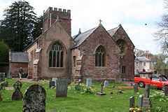
All Saints' Church
 Nynehead
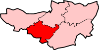
Nynehead shown within SomersetPopulation 416 [1] OS grid reference ST135225 District Taunton Deane Shire county Somerset Region South West Country England Sovereign state United Kingdom Post town WELLINGTON Postcode district TA21 Dialling code 01823 Police Avon and Somerset Fire Devon and Somerset Ambulance South Western EU Parliament South West England UK Parliament Taunton Deane List of places: UK • England • Somerset Nynehead is a village and civil parish in Somerset, England, situated on the River Tone, 7 miles (11 km) south-west of Taunton and 1.5 miles (2 km) north-west of Wellington, in the Taunton Deane district. The village has a population of 416.[1]
Contents
History
The first documentary evidence comes from 737 when the manor was granted to the Bishop of Winchester. In 890 the land was granted to a Wulfhere Gidding.[2] The parish of Nynehead was part of the Taunton Deane Hundred.[3]
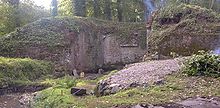 The remains of Nynehead boat lift
The village was the site of a boat lift on the Grand Western Canal,[4][5] and the remains of two aqueducts are still standing.[6][7]
Governance
The parish council has responsibility for local issues, including setting an annual precept (local rate) to cover the council’s operating costs and producing annual accounts for public scrutiny. The parish council evaluates local planning applications and works with the local police, district council officers, and neighbourhood watch groups on matters of crime, security, and traffic. The parish council's role also includes initiating projects for the maintenance and repair of parish facilities, as well as consulting with the district council on the maintenance, repair, and improvement of highways, drainage, footpaths, public transport, and street cleaning. Conservation matters (including trees and listed buildings) and environmental issues are also the responsibility of the council.
The village falls within the Non-metropolitan district of Taunton Deane, which was formed on April 1, 1974 under the Local Government Act 1972, having previously been part of Wellington Rural District.[8] The district council are responsible for local planning and building control, local roads, council housing, environmental health, markets and fairs, refuse collection and recycling, cemeteries and crematoria, leisure services, parks, and tourism.
Somerset County Council are responsible for running the largest and most expensive local services such as education, social services, libraries, main roads, public transport, policing and fire services, trading standards, waste disposal and strategic planning.
It is also part of the Taunton Deane county constituency represented in the House of Commons of the Parliament of the United Kingdom. It elects one Member of Parliament (MP) by the first past the post system of election, and part of the South West England constituency of the European Parliament which elects seven MEPs using the d'Hondt method of party-list proportional representation.
Landmarks
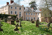 Nynehead Court
Nynehead Court dates from the late 14th century with major additions in 1675 and the 18th century.[9][10] The 13 acres (5 ha) landscape park was laid out in the 18th century, although major landscaping works were carried out in the early 19th century. It is now used as a nursing home.[11] The icehouse within the grounds dates from 1803 and has been restored with support from Taunton Deane Council.[12]
The Nynehead Hollow is another prominent landmark in the village. It is believed that the "Hollow" was dug out by the Sandford family in the hope of making Nynehead Court quicker to get to from the servent houses which were situated in east Nynehead.
Religious sites
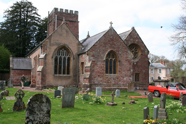
The church, dedicated to All Saints, is a small structure built of mostly of local red Permo-Triassic rock,[2] probably on the site of an earlier church, with a square tower containing five bells. The interior of the church contains some monuments to the Sanford family of Nynehead Court.[13] The building has been designated by English Heritage as a Grade I listed building.[14]
References
- ^ a b "Taunton Deane 2002 parish population estimates". Somerset County Council. http://www.webcitation.org/5lRyCZwqu. Retrieved 27 December 2009.
- ^ a b "Origins and Foundation of All Saints' Church, Nynehead". Nynehead parish website. http://www.nynehead.org/index.php?option=com_content&view=article&id=54&Itemid=322. Retrieved 2010-11-11.
- ^ "Somerset Hundreds". GENUKI. http://www.genuki.org.uk/big/eng/SOM/Miscellaneous/. Retrieved 21 October 2011.
- ^ "The boat lift on the Grand Western at Nynehead". Nynehead parish website. http://www.nynehead.org/index.php?option=com_content&view=article&id=27&Itemid=87. Retrieved 2010-11-11.
- ^ "Remains of vertical lift on former Grand Western Canal.". Images of England. http://www.imagesofengland.org.uk/details/default.aspx?id=270999. Retrieved 2007-12-06.
- ^ "Aqueduct, formerly carrying Grand Western Canal over driveway to Nynehead Court". Images of England. http://www.imagesofengland.org.uk/details/default.aspx?id=270995. Retrieved 2007-12-06.
- ^ "Aqueduct formerly carrying the Grand Western Canal over the River Tone, now disused". Images of England. http://www.imagesofengland.org.uk/details/default.aspx?id=270996. Retrieved 2007-12-06.
- ^ A Vision of Britain Through Time : Wellington Rural District
- ^ "Nynehead Court and wall adjoining on north side of forecourt". Images of England. http://www.imagesofengland.org.uk/details/default.aspx?id=271014. Retrieved 2007-12-06.
- ^ "Nynehead Court" (PDF). Taunton Deane. http://www.tauntondeane.gov.uk/Forms/NyneheadCourt.pdf. Retrieved 2007-12-06.
- ^ "Nynehead Court". Care Homes Guide. http://carehomesguide.com/CHG_Nynehead_Court-66.aspx. Retrieved 2007-12-06.
- ^ "Nynehead Court icehouse" (PDF). Taunton Deane. http://www.tauntondeane.gov.uk/Forms/Heritage/icehouse.pdf. Retrieved 2007-12-06.
- ^ "Notes on the history of Nynehead Court" (PDF). Nynehead parish website. http://www.nynehead.org/pdfs/publications/whitaker.pdf. Retrieved 2007-12-06.
- ^ "Church of All Saints". Images of England. http://www.imagesofengland.org.uk/details/default.aspx?id=271007. Retrieved 2007-12-06.
External links
Towns, villages and hamlets in the Taunton Deane borough of Somerset, England  Ashbrittle · Ash Priors · Bathealton · Bickenhall · Bishop's Hull · Bishops Lydeard · Bradford on Tone · Burrowbridge · Cheddon Fitzpaine · Chipstable · Churchstanton · Combe Florey · Comeytrowe · Corfe · Cotford St Luke · Cothelstone · Creech St Michael · Curland · Durston · Fitzhead · Halse · Hatch Beauchamp · Kingston St Mary · Langford Budville · Lydeard St Lawrence · Milverton · North Curry · Norton Fitzwarren · Nynehead · Oake · Orchard Portman · Otterford · Pitminster · Ruishton · Sampford Arundel · Staple Fitzpaine · Stawley · Stoke St Gregory · Stoke St Mary · Taunton · Thornfalcon · Tolland · Trull · Wellington · Wellington Without · West Bagborough · West Buckland · West Hatch · West Monkton · WiveliscombeCategories:
- Villages in Taunton Deane
- Civil parishes in Somerset


Wikimedia Foundation. 2010.